丨 Product Introduction
1. Full frequency tracking: Supports receiving signals from multiple satellite systems at all frequency points.
2. High precision positioning: using RTK and other technologies to achieve centimeter level accuracy.
3. Advanced architecture: Based on Nebula IV design, it has strong performance.
4 High Reliability: Initialization reliability exceeds 99.9%.
丨 Specification parameters
|
Chip
characteristics
|
chip
|
UM980
|
|
working frequency
|
BDS: B1I B2I B3I B1C B2a B2b
GPS: L1 C/A L1C L2P (Y) L2C L5
GLONASS: L1 L2
Galileo: E1 E5a E5b E6
QZSS: L1 L2 L5 L6
|
|
Receiving channel
|
1408 channel
|
|
Accuracy
|
Single point positioning (RMS)
|
Plane: 1.5m
|
|
Elevation: 2.5m
|
|
DGPS(RMS)
|
Plane: 0.4m
|
|
Elevation: 0.8m
|
|
RTK(RMS)
|
Flat: 0.8cm+1ppm
|
|
Elevation: 1.5cm+1ppm
|
|
Observation accuracy (RMS)
|
BDS
|
GPS
|
GLONASS
|
Galileo
|
|
B1I/B1C/L1C/L1 C/A/E1/G1 pseudorange
|
10cm
|
10cm
|
10cm
|
10cm
|
|
B1I/B1C/L1C/L1 C/A/E1/G1 Carrier Phase
|
1mm
|
1mm
|
1mm
|
1mm
|
|
B3I/L2P(Y)/L2C/G2 pseudorange
|
10cm
|
10cm
|
10cm
|
10cm
|
|
B3I/L2P(Y)/L2C/G2
Carrier Phase
|
1mm
|
1mm
|
1mm
|
1mm
|
|
B2I/B2a/ B2b/L5/E5a/E5b pseudorange
|
10cm
|
10cm
|
10cm
|
10cm
|
|
B2I/B2a/ B2b/L5/E5a/E5b Carrier Phase
|
1mm
|
1mm
|
1mm
|
1mm
|
|
Time accuracy (RMS)
|
10 ns
|
|
Speed accuracy (RMS)
|
0.03 m/s
|
|
Start Time
|
cold boot
|
< 10s
|
|
Initialization time
|
<5s (typical value)
|
|
Initialize reliability
|
> 99.9%
|
|
Output data
|
Baud rate
|
115200bps (default) [Optional: 4800-921600]
|
|
Output interface
|
TTL
|
|
Output Protocol
|
NMEA0183、RTCM 3.3
|
|
update frequency
|
1Hz-20Hz (default 1Hz)
|
|
Differential
data
|
Differential data
|
RTCM 3.3/3.2/3.1/3.0
|
|
Carrier phase output
|
Support, output RAWX statement
|
|
FLASH
|
built-in
|
|
Electrical
specifications
|
working voltage
|
3~5.5V DC
|
|
power waste
|
<800mW @3.3V
|
|
Physical
parameters
|
size
|
45*11.5mm
|
|
weight
|
35.8g
|
|
Connector
|
GH1.25mm 8pin
|
|
Environment
|
working temperature
|
-35℃-80℃
|
|
Storage temperature
|
-40℃-95℃
|
|
compass
|
compass
|
IST8310
|
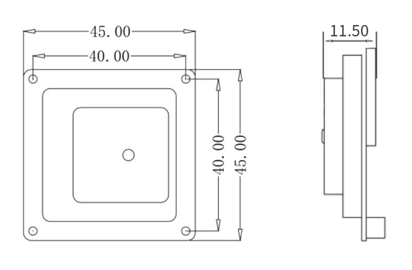
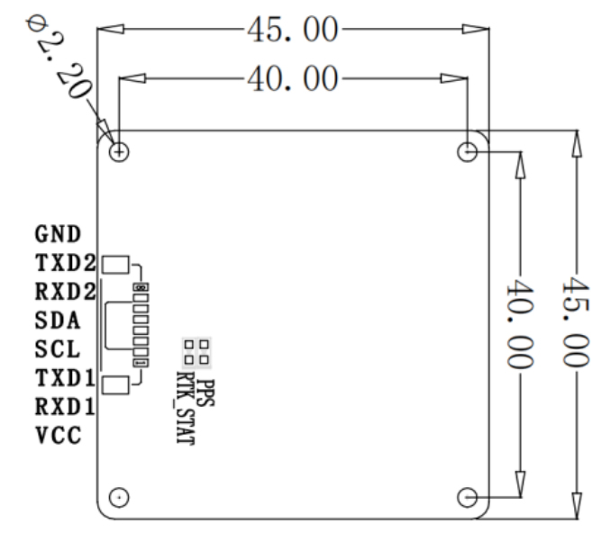
Table 1 PIN Function
|
NO.
|
Signal Name
|
Signal Description
|
|
1
|
VCC
|
Main power supply input, +3.3V to +5V
|
|
2
|
RXD1
|
First serial receive data pin, used for receiving serial date streams.
|
|
3
|
TXD1
|
First serial transmit data pin, used for receiving serial date streams.
|
|
4
|
SCL
|
Clock line in the l2C communication protocol, used for synchronizing data transfer.
|
|
5
|
SDA
|
Data line in the l2C communication protocol, used for bidirectional data transfer.
|
|
6
|
RXD2
|
Serial receive data pin, similar to RXD1, used for receiving another serial data stream.
|
|
7
|
TXD2
|
Serial transmit data pin, similar to TXD1, used for sending another serial data stream.
|
|
8
|
GND
|
Ground pin, used for connecting to the circuit's ground, providing the reference voltage needed for the circuit loop.
|
|
Note: Typically, VCC and GND are used for power supply, TX and RX are used for serial communication, while SCL and SDA are used for I²C communication. These interfaces allow the receiver to exchange power supply and data with external devices.
|

Product Overview
The DALANG AK726 is a multi-band, multi-system GNSS receiver module designed for centimeter-level accuracy, supporting GPS, BDS, GLONASS, and Galileo. This high-performance RTK solution is ideal for UAV navigation, precision agriculture, and surveying applications.
High-Frequency RTK Engine for Real-Time Precision
Equipped with an advanced multi-frequency RTK engine, the AK726 delivers real-time differential correction and stable GNSS data across varied terrains. Whether deployed on autonomous drones or ground vehicles, it ensures precise positioning for demanding workflows.
Designed for Open-Source Flight Controllers and Integration
Fully compatible with open-source systems like ArduPilot, PX4, and custom platforms, the AK726 supports flexible deployment and long-term scalability, making it an ideal choice for UAV developers and system Integrators.
Reliable Performance in Challenging Environments
With strong anti-interference capability and high signal sensitivity, the AK726 performs consistently in urban canyons, mountainous areas, and dense foliage, providing continuous and reliable GNSS output in real-world conditions.
Key Features
-
Multi-system, multi-frequency support for fast convergence and stable centimeter-level positioning
-
Open-source compatibility & integration-friendly, suitable for OEM and custom development
-
Excellent performance in challenging environments with reliable RTK resolution under interference and signal blockage
-
High performance with low power consumption, compact design for UAVs, AGVs, and mobile platforms
Looking for a reliable high-precision positioning solution for your UAV or agricultural system? Upgrade your project with real-time RTK performance by choosing the DALANG AK726 GNSS module today.
About Us
DALANG is a dedicated manufacturer of high-performance GNSS modules and RTK positioning solutions, serving industries such as UAV navigation, precision agriculture, and geospatial mapping. With a clear focus on accuracy, reliability, and integration flexibility, we support both standard and custom applications across global markets. Our product lines are engineered to meet the evolving demands of real-time positioning with support for multiple GNSS constellations, including GPS, GLONASS, BDS, and Galileo.
Our production facility spans 2,500㎡ and includes advanced SMT lines, in-house R&D labs, and full functional testing for every unit shipped. With a team of 30+ GNSS engineers, we design and manufacture over 200,000 GNSS receivers and modules annually. Certified to ISO9001:2015, and compliant with CE and RoHS standards, we follow a strict quality assurance process from prototyping through mass production. We also provide firmware updates, system integration support, and full lifecycle product documentation.
Trusted by partners in over 30 countries, DALANG delivers fast, scalable manufacturing with personalized technical support. Our streamlined collaboration model—covering inquiry, consultation, prototyping, and delivery—ensures efficiency from first contact to deployment. Whether you're sourcing off-the-shelf GNSS hardware or launching a customized solution, DALANG is your dependable partner for accurate, cost-effective positioning systems.
FAQ
1. Who are we?
We are DALANG, a specialized manufacturer of GNSS modules and RTK positioning systems based in China, with a focus on high-precision solutions for UAVs, surveying, and smart agriculture.
2. How can we guarantee quality?
All products undergo strict multi-stage quality control, including SMT production, functional testing, and 100% final inspection. We are ISO9001:2015 certified and follow international compliance standards such as CE and RoHS.
3. What can you buy from us?
You can purchase GNSS receivers, RTK modules, base stations, antennas, flight control positioning systems, and other GNSS-related components and accessories.
4. Why should you buy from us not from other suppliers?
We combine strong in-house R&D, flexible OEM/ODM support, industrial-grade quality assurance, and fast global delivery. Our expertise in GNSS RTK ensures stable, accurate, and scalable solutions tailored to your specific use case.
5. What services can we provide?
We offer OEM/ODM customization, technical consulting, firmware support, prototyping, and global after-sales service. Our team works closely with international clients to ensure efficient communication and long-term support.