Product Advantages
Modular Design with Robust System Integration
The DroneCAN GNSS module excels in its structural and system design, featuring a compact form factor optimized for easy integration with Pixhawk RTK module and other autopilots. The fusion of the UM980 RTK engine and RM3100 compass ensures reliable orientation data alongside high-precision positioning. Utilizing UAVCAN protocols allows flexible communication in complex drone systems, while its efficient power consumption supports extended flight times. This high precision drone RTK module’s modularity accommodates both base and rover station configurations, delivering adaptability within mixed GNSS ecosystems for professional UAV deployments.
Superior Performance and User-centric Features
Users of this GNSS GPS RTK module for UAV benefit from exceptional centimeter-level accuracy paired with flexible output rates, enabling real-time decision-making during autonomous flights or surveying missions. The high precision drone RTK module’s compatibility with mainstream autopilots like Pixhawk enhances usability with an intuitive setup experience. Built-in STM32 processing supports onboard data handling, reducing latency and enhancing responsiveness. End users appreciate the reliability under challenging conditions, low power needs, and the precision provided by the UAVCAN RTK module communication, making it an invaluable tool for improving operational outcomes in drone navigation.
 丨 Product Introduction
The AK713CAN module integrates the RM3100 compass and UM980 full-system full-frequency RTK engine, supports both rover and base station modes, and achieves centimeter-level positioning accuracy of 1cm static and 2cm dynamic via carrier phase differential technology, with an output rate of 1~20Hz, suitable for UAV, automotive and surveying applications.
Key Features:
- High Stability:Based on the UM980 series, the module delivers stable and high-precision positioning even in harsh environments, with optimized signal reception and enhanced adaptability to temperature and humidity changes.
- Powerful Processing:Built-in STM32 chip enables robust performance for real-time data processing and optimization.
- Reliable Data Output:Complies with UAVCAN standard protocol for high real-time performance and strong anti-interference ability.
- Wide Compatibility:Fully compatible with Pixhawk, APM and other autopilot systems.
丨Specification parameters
|
Chip
characteristics
|
Satellite chip
|
UM980
|
|
Operating Frequency
|
BDS: B1I B2I B3I B1C B2a B2b
GPS: L1 C/A L1C L2P (Y) L2C L5
GLONASS: L1 L2
Galileo: E1 E5a E5b E6
QZSS: L1 L2 L5 L6
|
|
DGPS(RMS)
|
Plane: 0.4m
|
|
Elevation: 0.8m
|
|
RTK(RMS)
|
Flat: 0.8cm+1ppm
|
|
Elevation: 1.5cm+1ppm
|
|
Time accuracy (RMS)
|
10ns
|
|
maximum speed
|
500 m/s
|
|
Speed accuracy (RMS)
|
0.03m/s
|
|
refresh rate
|
20Hz (maximum)
|
|
Start Time
|
cold start
|
<25s
|
|
Initialization time
|
<5s (typical value)
|
|
Output data
|
communication protocol
|
DroneCAN/UAVCAN
|
|
Baud rate
|
1Mbps
|
|
Differential data
|
differential data
|
RTCM 3.3/3.2/3.1/3.0 (only supports RTCM data input from UART2)
|
|
Electrical
specifications
|
Working Voltage
|
5.0V DC
|
|
power consumption
|
800mW
|
|
Physical
parameters
|
size
|
Standard version:φ42*31.2mm
Upgraded version:φ44*40.6mm
|
|
weight
|
Standard version: 13.2g
Upgraded version: 21g
|
|
joint
|
GH1.25mm 8pin
|
|
Environment
|
Operating Temperature
|
-35℃-70℃
|
|
Storage temperature
|
-40℃-95℃
|
|
Compass
|
industrial-grade
|
RM3100
|
丨product mix
Standard version: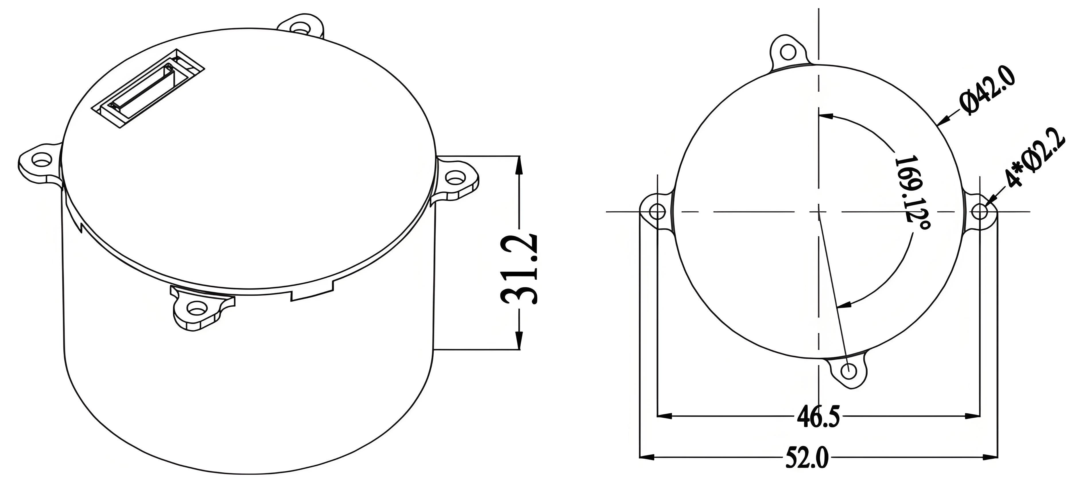 Upgraded version:
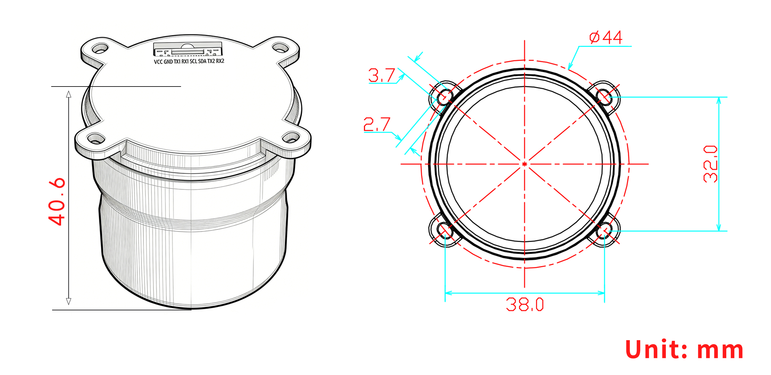

Table 1 PIN Function
|
NO.
|
Signal Name
|
Signal Description
|
|
1
|
VCC
|
Main power input, +3.3V to 5V
|
|
2
|
GND
|
Module ground
|
|
3
|
TX1
|
UART1 output, 3.3V TTL
|
|
4
|
RX1
|
UART1 input, 3.3V TTL
|
|
5
|
SCL
|
I²C Serial Clock (IST8310)
|
|
6
|
SDA
|
I²C Serial Data (IST8310)
|
|
7
|
TX2
|
UART2 output, 3.3V TTL
|
|
8
|
RX2
|
UART2 input, 3.3V TTL
|
 Ready to elevate your precision positioning? Contact our team today for a customized solution tailored to your needs!
Packaging and Delivery:

Use Scenarios
Precision Mapping and Surveying with Rover/Base Station Configurations
In the surveying and mapping industry, the DroneCAN GNSS module plays a critical role by providing centimeter-level RTK positioning, crucial for accurate topographical data collection. Deployed as either a rover or base station, this module ensures data integrity during field operations. It complies with stringent geospatial accuracy standards, maintaining continuous satellite tracking across multiple constellations. Integrated with Pixhawk flight controllers, it allows smooth data flow into autopilot systems, facilitating automated flights with real-time corrections. This integration streamlines workflows in agriculture, construction, and land surveying applications requiring precise geospatial measurements.
Autonomous UAV Navigation in Complex Environments
The high precision drone RTK module is indispensable for autonomous UAVs operating in demanding environments such as infrastructure inspection or environmental monitoring. It provides robust, interference-resistant positioning data necessary for precise navigation and waypoint adherence in GPS-challenged settings. Leveraging UAVCAN RTK module protocols, the module communicates efficiently with onboard flight controllers like the Pixhawk RTK module, ensuring dependable real-time positioning corrections. This capability enhances operational safety and mission success rates, enabling drones to execute complex flight plans with centimeter-level accuracy under variable weather and terrain conditions.
FAQ
Is the DroneCAN High Precision UM980/RM3100 module compatible with autopilots other than Pixhawk?
Yes, our DroneCAN GNSS module is fully compatible with Pixhawk, APM, and other widely used autopilot systems. It supports UAVCAN protocols to ensure reliable real-time performance and easy integration across multiple flight controllers.
What kind of positioning accuracy and update rates does this UAVCAN RTK module provide?
Our module uses advanced carrier phase differential technology to deliver centimeter-level accuracy—1 cm static and 2 cm dynamic. The output rate is adjustable from 1 Hz up to 20 Hz to meet various real-time flight and surveying needs.
Can I customize the DroneCAN RTK module for specific UAV projects or different operational modes?
We offer customization inquiries on request. While standard configurations support rover and base station modes, please contact us to discuss tailor-made options or lead time details for your Pixhawk RTK module requirements.
What are the power and environmental tolerances of this high precision drone RTK module?
The module operates at 5.0 V with a power consumption of 800 mW. It performs reliably in temperatures ranging from -35 °C to 70 °C, making it suitable for a variety of demanding UAV and surveying environments.