 丨 Product Introduction
1. High data output: Supports up to 50Hz data output, suitable for high-speed mobile drone positioning, ensuring continuous and stable trajectory tracking.
2. Compatibility: Fully compatible with automatic flight control systems such as Pixhawk and APM, making it easy to integrate multiple flight platforms.
3. Built in IUD: solves the problem of positioning interruption caused by satellite signal loss of lock.
4. Compass configuration: Built in electronic compass RM3100 to enhance signal accuracy.
丨 Specification parameters
|
Chip
characteristics
|
chip
|
UM981
|
|
working
frequency
|
BDS: B1I B2I B3I B1C B2a B2b
GPS: L1 C/A L1C L2P (Y) L2C L5
GLONASS: L1 L2
Galileo: E1 E5a E5b E6
QZSS: L1 L2 L5 L6
NavIC L5
SBAS L1C/A
|
|
Receiving channel
|
1408 channel
|
|
Sensitivity
|
track
|
-167 dBm
|
|
cold boot
|
-148 dBm
|
|
Hot start
|
-157 dBm
|
|
First positionin
time TTFF
|
cold boot
|
26s
|
|
Hot start
|
2s
|
|
Re capture
|
2s
|
|
Inertial navigation accuracy
|
<5% x driving distance (no GNSS signal)
|
|
Accuracy
|
Horizontal Accuracy
|
Normal positioning: 1.5m CEP
|
|
RTK positioning: 0.8cm+1 ppm CEP
|
|
speed accuracy
|
0.05m/s
|
|
Second pulse accuracy
|
30ns
|
|
Output data
|
Baud rate
|
115200bps (default) [Optional: 4800-921600]
|
|
Output interface
|
TTL
|
|
Output Protocol
|
NMEA0183、Unicore
|
|
Data update frequency
|
100Hz (IMU Raw Data)
|
|
Default 1Hz (0.25Hz-50Hz)
|
|
Carrier phase output
|
Support, output RAWX statement
|
|
FLASH
|
built-in
|
|
Working
conditions
|
height
|
<50,000m
|
|
speed
|
<500m/s
|
|
Gravitational acceleration
|
<4g
|
|
Electrical
specifications
|
working voltage
|
3V-5.5V DC
|
|
power waste
|
800mW @3.3V
|
|
Physical
parameters
|
size
|
Standard version:φ42*31.2mm
Upgraded version:φ44*40.6mm
|
|
weight
|
Standard version: 13.2g
Upgraded version: 21g
|
|
Connector
|
GH1.25mm 8pin
|
|
Environment
|
working temperature
|
-35℃-80℃
|
|
Storage temperature
|
-40℃-85℃
|
|
Compass
|
Compass
|
RM3100
|
丨 product mix
Standard version: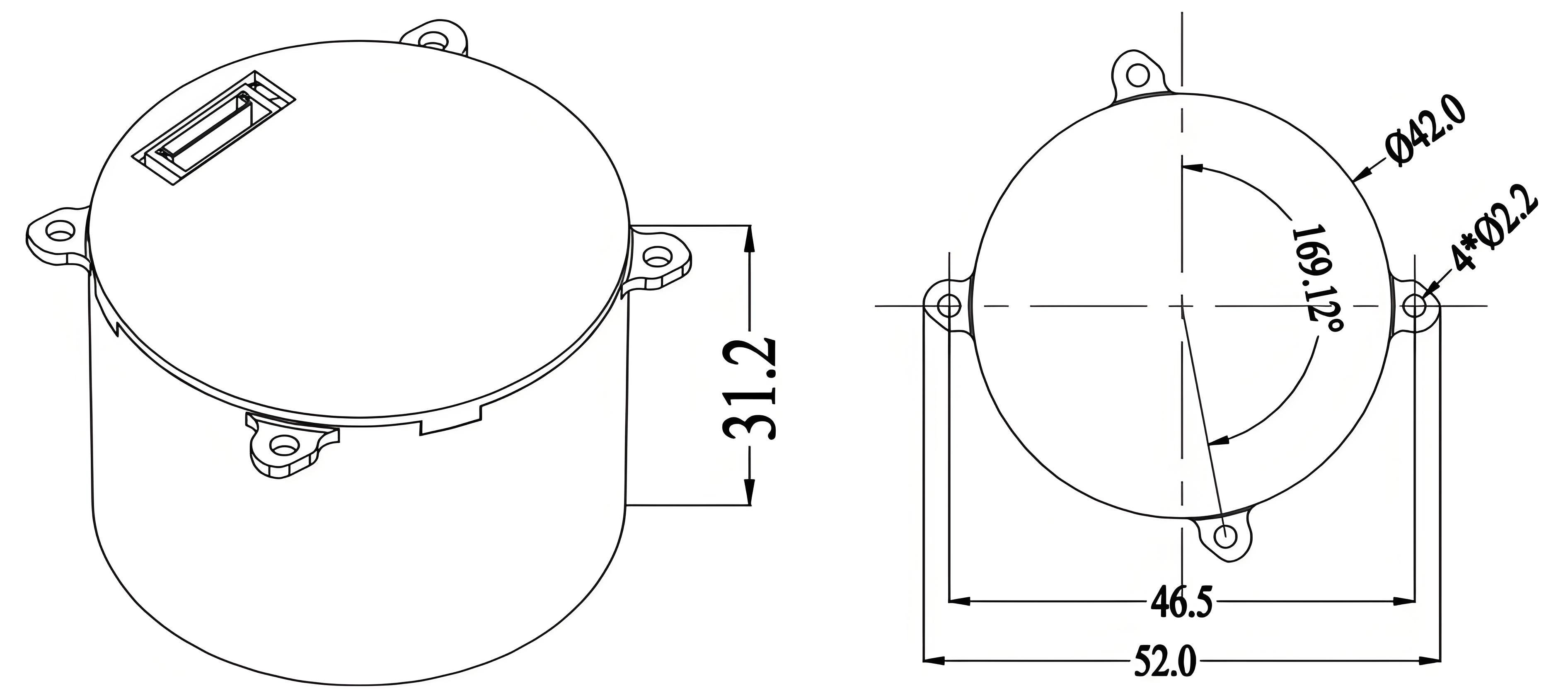
Upgraded version: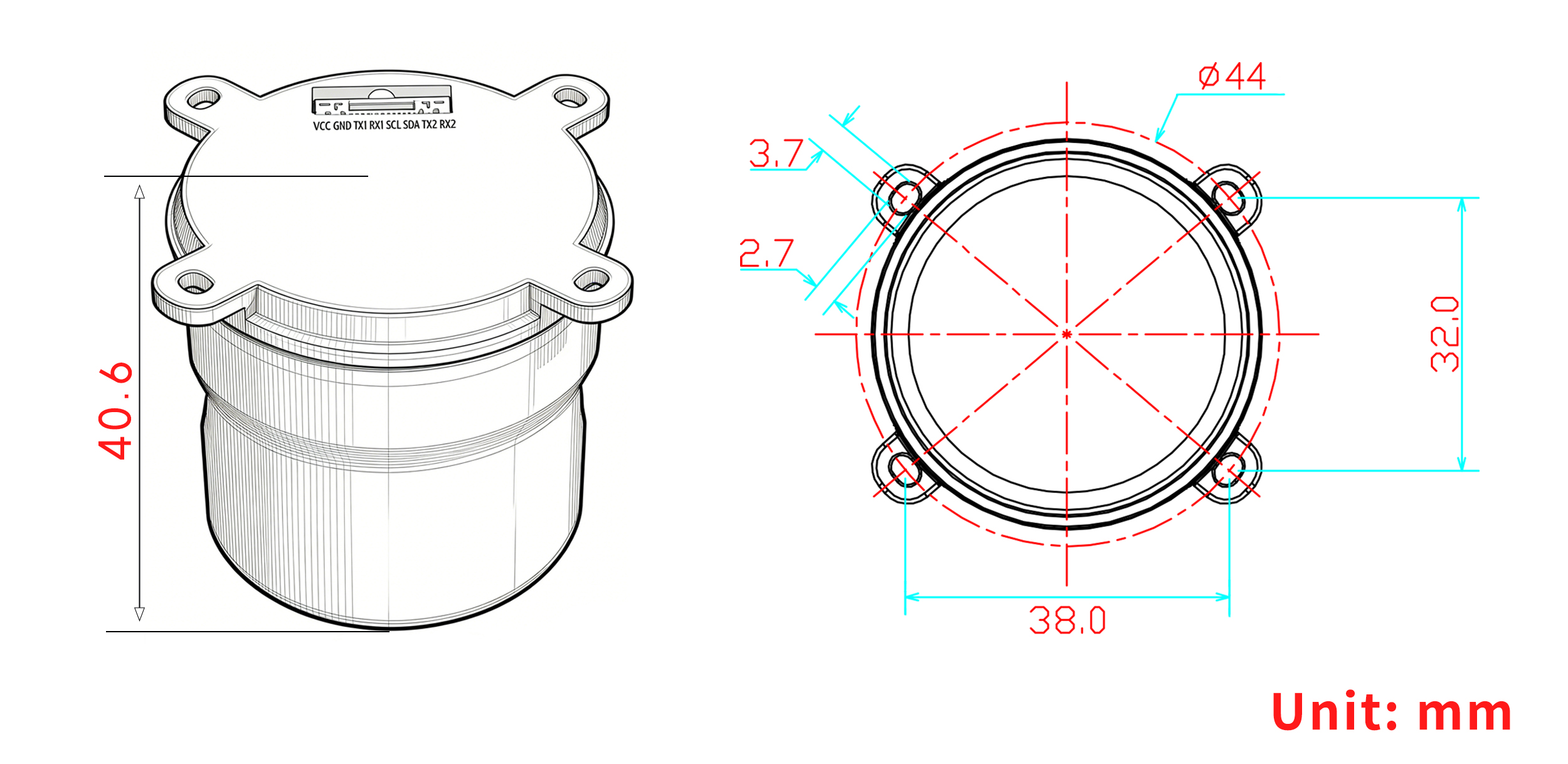

Table 1 PIN Function
|
NO.
|
Signal Name
|
Signal Description
|
|
1
|
VCC
|
Main power input, +3.3V to 5V
|
|
2
|
GND
|
Module ground
|
|
3
|
TX1
|
UART1 output, 3.3V TTL
|
|
4
|
RX1
|
UART1 input, 3.3V TTL
|
|
5
|
SCL
|
I²C Serial Clock (RM3100)
|
|
6
|
SDA
|
I²C Serial Data (RM3100)
|
|
7
|
TX2
|
UART2 output, 3.3V TTL
|
|
8
|
RX2
|
UART2 input, 3.3V TTL
|

Product OverviewThe DALANG AK723RM is a next-generation RTK/INS integrated navigation module based on the UM981 chip. Built on the NebulasIV GNSS SoC, it delivers 100 Hz positioning output and maintains continuous positioning in GNSS-denied environments through integrated MEMS sensors and U-Fusion algorithms.
Multi-System SupportSupports BDS, GPS, GLONASS, Galileo, QZSS, NavIC, and SBAS for reliable positioning.
INS IntegrationOnboard IMU provides <5% distance error in inertial navigation mode when satellite signals are unavailable.
Compact DesignWeighing only 21g with dimensions of Φ44×40.6mm, ideal for weight-sensitive applications.
Key Features
100 Hz Output: Meets high-dynamic positioning requirements
All-System Support: Compatible with 7 global navigation systems
INS Navigation: <5% distance error without GNSS signals
Industrial Reliability: Operating temperature -35℃ to 80℃
Lightweight: 21g for easy integration
RM3100 Magnetometer: Provides accurate heading reference
Built for UAVs, agriculture, and surveying applications requiring continuous precision positioning. DALANG AK723RM - your reliable choice in challenging environments.
About Us
DALANG is a dedicated manufacturer of high-performance GNSS modules and RTK positioning solutions, serving industries such as UAV navigation, precision agriculture, and geospatial mapping. With a clear focus on accuracy, reliability, and integration flexibility, we support both standard and custom applications across global markets. Our product lines are engineered to meet the evolving demands of real-time positioning with support for multiple GNSS constellations, including GPS, GLONASS, BDS, and Galileo.
Our production facility spans 2,500㎡ and includes advanced SMT lines, in-house R&D labs, and full functional testing for every unit shipped. With a team of 30+ GNSS engineers, we design and manufacture over 200,000 GNSS receivers and modules annually. Certified to ISO9001:2015, and compliant with CE and RoHS standards, we follow a strict quality assurance process from prototyping through mass production. We also provide firmware updates, system integration support, and full lifecycle product documentation.
Trusted by partners in over 30 countries, DALANG delivers fast, scalable manufacturing with personalized technical support. Our streamlined collaboration model—covering inquiry, consultation, prototyping, and delivery—ensures efficiency from first contact to deployment. Whether you're sourcing off-the-shelf GNSS hardware or launching a customized solution, DALANG is your dependable partner for accurate, cost-effective positioning systems.
FAQ
Is the UM981 module compatible with popular autopilot systems like Pixhawk or APM?
Yes, we fully support integration with autopilot systems such as Pixhawk and APM. Our module’s RTK GPS module design and standard TTL interface ensure seamless connection and reliable performance in various UAV navigation setups.
Can the UM981 module be customized for different UAV applications?
We offer customization options to fit specific UAV needs, including firmware adaptations and physical module sizes. Our expert team can help tailor the module to your project requirements, making it easier for you to buy GNSS receiver solutions that match your use case.
What are the installation requirements for the UM981 GNSS module?
Our module has a compact and lightweight design, with GPIO/TTL interfaces compatible with most UAV flight controllers. Installation guidelines are provided to ensure optimal antenna placement for best satellite reception and to maximize GPS navigation accuracy.
How do you support maintenance and firmware updates for the UM981 module?
We provide ongoing support including firmware updates and detailed product documentation to maintain system reliability. This ensures your GPS system stays current with the latest navigation features and performance improvements for UAV applications.