丨 Product Introduction
1.Full frequency: Supports multi satellite full frequency tracking such as BDS and GPS, ensuring stable positioning in complex scenarios.
2.Anti interference: 60dB narrowband anti-interference, ensuring positioning stability.
3.Efficient: Instantaneous RTK, battery assisted "hot start", reducing the time required for initial positioning.
4.Multipurpose: Mobile station/base station dual-mode, measurement mode adapted to multiple scenarios.
丨 Specification parameters
| picture |
1
|
picture
|
|
|
|
Chip
characteristics
|
2
|
Chip
|
UM980
|
UM982
|
|
3
|
Operating Frequency
|
BDS: B1I B2I B3I B1C B2a B2b
GPS: L1 C/A L1C L2P (Y) L2C L5
GLONASS: L1 L2
Galileo: E1 E5a E5b E6
QZSS: L1 L2 L5 L6
|
BDS: B1I、B2I、B3I
GPS: L1C/A、L2P (Y)、L2C、L5
GLONASS: L1、L2
Galileo: E1、E5a、E5b
QZSS: L1、L2、L5
|
|
4
|
Receiving channel
|
1408 channel
|
1408 channel
|
|
Accuracy
|
1
|
Single point positioning (RMS)
|
Plane: 1.5m
|
Plane: 1.5m
|
|
2
|
Elevation: 2.5m
|
Elevation: 2.5m
|
|
3
|
DGPS(RMS)
|
Plane: 0.4m
|
Plane: 0.4m
|
|
4
|
Elevation: 0.8m
|
Elevation: 0.8m
|
|
5
|
RTK(RMS)
|
Flat: 0.8cm+1ppm
|
Flat: 0.8cm+1ppm
|
|
6
|
Elevation: 1.5cm+1ppm
|
Elevation: 1.5cm+1ppm
|
|
7
|
time accuracy
(RMS)
|
10ns
|
20ns
|
|
8
|
Speed accuracy
(RMS)
|
0.03m/s
|
0.2 m/s
|
|
Start Time
|
1
|
cold start
|
<10s
|
<20s
|
|
2
|
initialization time
|
<5s(Typical value)
|
<5s (typical value)
|
|
3
|
Initialize reliability
|
>99.9%
|
>99.9%
|
|
Output data
|
1
|
Baud rate
|
115200bps (default) [Optional: 4800-921600]
|
115200bps (default) [Optional: 4800-921600]
|
|
2
|
output interface
|
TTL/USB
|
TTL/USB
|
|
3
|
Output Protocol
|
NMEA0183、RTCM 3.3
|
NMEA0183、RTCM 3.3
|
|
4
|
update frequency
|
1Hz-20Hz(default 1Hz)
|
1Hz-20Hz (default 1Hz)
|
|
Differential
data
|
1
|
Differential data
|
RTCM 3.3/3.2/3.1/3.0
|
RTCM 3.3/3.2/3.1/3.0
|
|
2
|
Carrier phase output
|
Support, output RAWX statement
|
Support, output RAWX statement
|
|
3
|
FLASH
|
built-in
|
built-in
|
|
Electrical
specifications
|
1
|
working voltage
|
3~5.5V DC
|
3~5.5V DC
|
|
2
|
power consumption
|
<800mW
|
<800mW
|
|
Physical
parameters
|
1
|
size
|
67*45*16.4mm
|
67*45*16.4mm
|
|
2
|
weight
|
31g
|
31.2g
|
|
3
|
Housing material
|
aluminium
|
aluminium
|
|
4
|
connector
|
TYPE-C/GH1.25mm 8pin
|
TYPE-C/ GH1.25mm 8pin
|
|
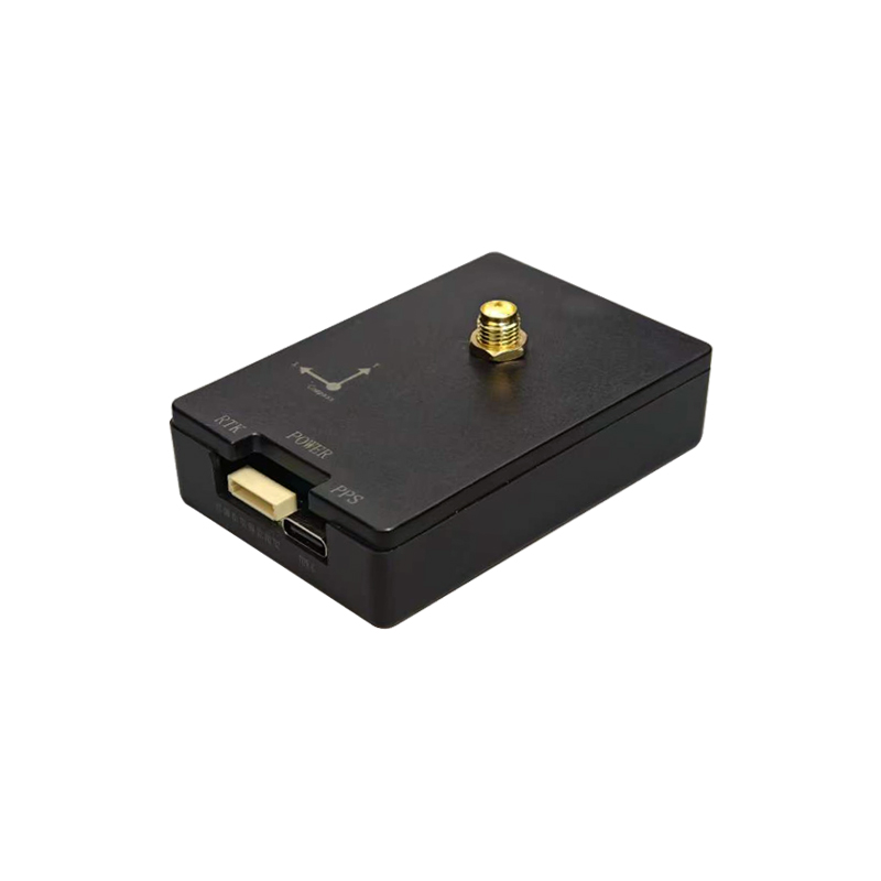
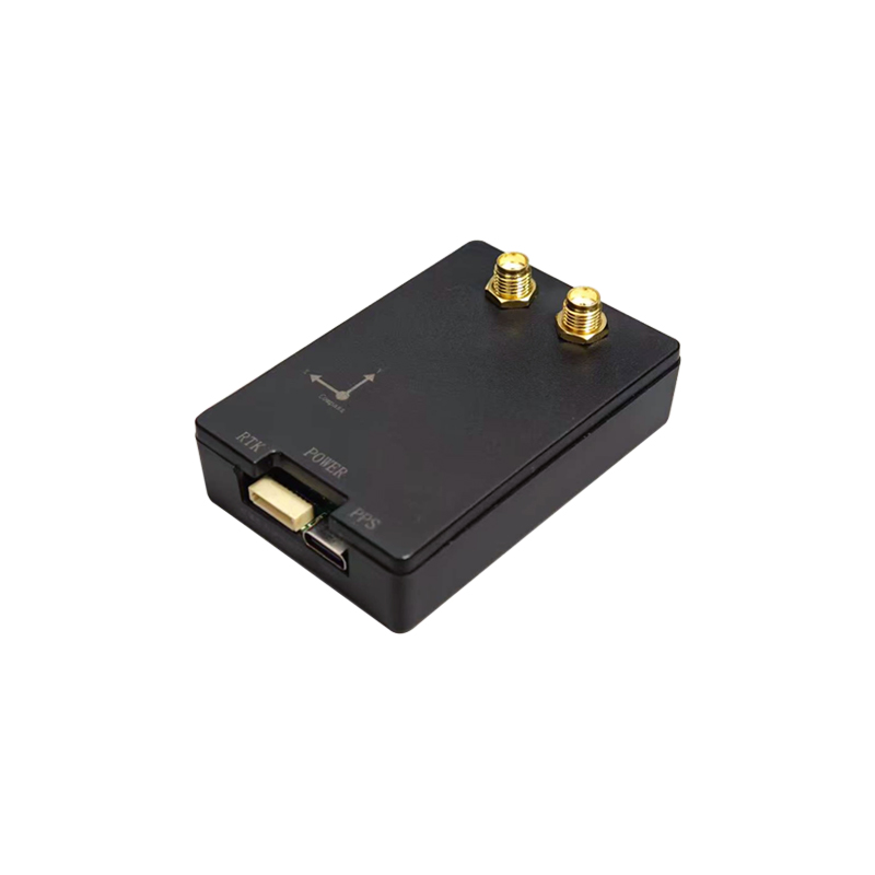
5
|
Connector
|
SMA straight head
|
SMA straight head*2
|
|
Environment
|
1
|
operation temperature
|
-35℃-80℃
|
-35℃-80℃
|
|
2
|
storage temperature
|
-40℃-95℃
|
-40℃-85℃
|
|
Compass
|
1
|
compass
|
IST8310
|
IST8310
|
|
picture
|
1
|
picture
|
|
|
|
Antenna
characteristics
|
1
|
working frequency
|
GPS: L1, L2, L5
BDS: B1I, B2I, B3I, B2a, B2b
GLONASS: L1, L2, L3
Galileo: E1, E5b, E5a, E6
QZSS: L1, L2, L5, L6
IRNSS: L5
|
GPS: L1, L2, L5
BDS: B1I, B2I, B3I, B2a, B2b
GLONASS: L1, L2, L3
Galileo: E1, E5b, E5a, E6
QZSS: L1, L2, L5, L6
IRNSS: L5
|
|
2
|
frequency range
|
1176-1278/1559-1612MHz
|
1176-1278/1559-1612MHz
|
|
3
|
V. S.W.R (standing wave ratio)
|
≤2.0
|
≤2.0
|
|
4
|
Axis ratio
|
Elevation angle of 90 degrees: ≤ 3, elevation angle of 15 degrees: ≤ five
|
Elevation angle of 90 degrees: ≤ 3, elevation angle of 15 degrees: ≤ five
|
|
5
|
Gain
|
Elevation angle of 90 degrees: ≥ 6, elevation angle of 20 degrees: ≥ 0 dB
|
Elevation angle of 90 degrees: ≥ 6, elevation angle of 20 degrees: ≥ 0 dB
|
|
6
|
Before and after comparison
|
± 60 degrees ≥ 15dB
|
± 60 degrees ≥ 15dB
|
|
7
|
Phase center (mm)
|
<2
|
<2
|
|
8
|
impedance
|
50Ω
|
50Ω
|
|
9
|
Polarization mode
|
RHCP
|
RHCP
|
|
10
|
Out of band inhibition
|
1268+100MHZ≥50db,
1170-100MHZ≥50db,
1602+100MHZ≥50db,
1561-100MHZ ≥50db.
|
1268+100MHZ≥50db,
1170-100MHZ≥50db,
1602+100MHZ≥50db,
1561-100MHZ ≥50db.
|
|
LNA
|
1
|
LNA gain
|
38±2dB
|
38±2dB
|
|
2
|
V. S.W.R (standing wave ratio)
|
<2
|
<2
|
|
3
|
Flatness within the band
|
±2dB
|
±2dB
|
|
4
|
Noise coefficient
|
<2.0
|
<2.0
|
|
5
|
DC power supply
|
3.3~16V
|
3.3~16V
|
|
6
|
Working current
|
<35 mA
|
<25 mA
|
|
Mechanical
structure
|
1
|
Component Name
|
SPEC
|
SPEC
|
|
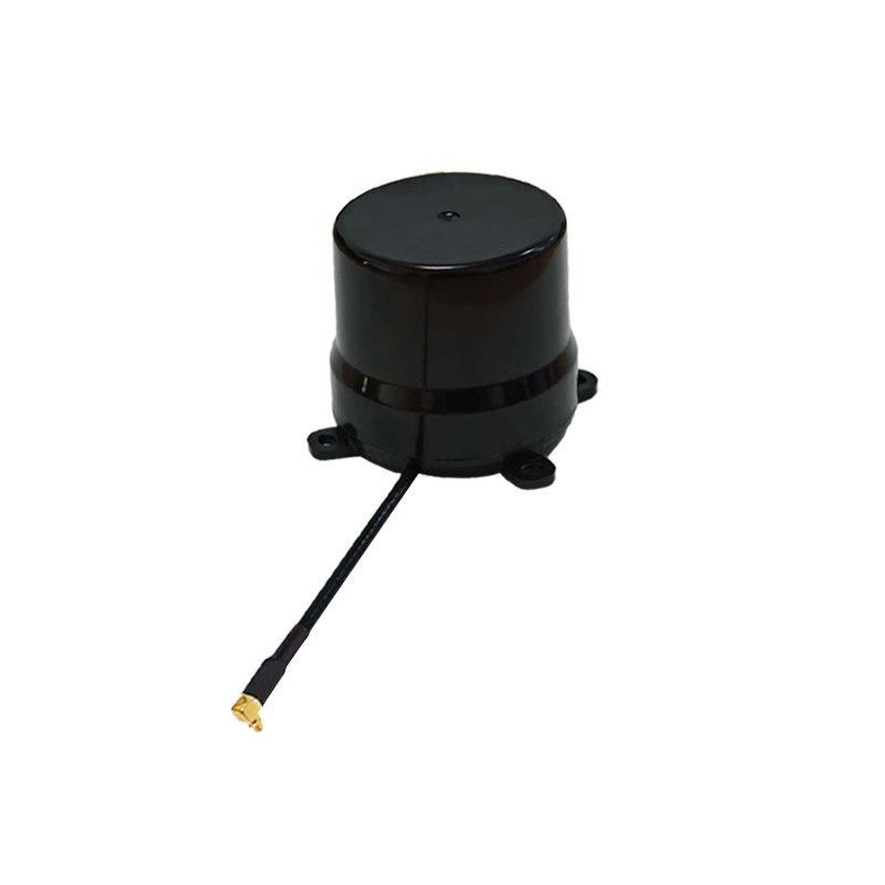
2
|
antenna
|
Four arm spiral
|
Four arm spiral
|
|
3
|
Installation method
|
Threaded connection
|
Threaded connection
|
|
4
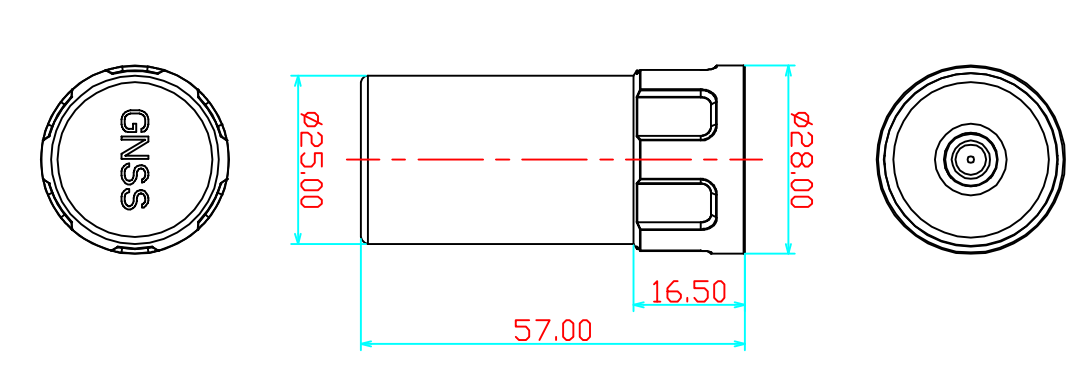
|
Antenna size
|
Φ57*28mm
|
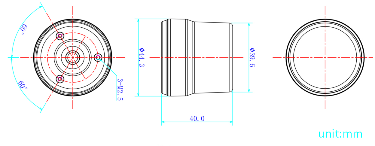
Φ44.3*40mm
|
|
5
|
Product weight
|
16g
|
24.6g
|
|
6
|
RF output interface
|
SMA(internal spiral pattern needle)
|
SMA(internal spiral pattern needle)
|
|
7
|
Antenna casing
|
ABS+PC
|
ABS+PC
|
|
Environmental
|
1
|
working temperature
|
-40℃~+85℃, 10%~95% RH
|
-40℃~+85℃, 10%~95% RH
|
|
2
|
Storage temperature
|
-55℃~+100℃, 10%~95% RH
|
-55℃~+100℃, 10%~95% RH
|
|
3
|
shock
|
Sine scan @ 1.5mm AM, 10~55Hz per axis
|
Sine scan @ 1.5mm AM, 10~55Hz per axis
|
|
picture
|
1
|
picture
|
|
|
|
Electrical
Characteristics
|
1
|
Operating Frequency
|
GPS: L1, L2, L5
BDS: B1I, B2I, B3I, B2a, B2b
GLONASS: L1, L2, L3
Galileo: E1, E5b, E5a, E6
QZSS: L1, L2, L5, L6
IRNSS: L5
|
GPS: L1, L2, L5
BDS: B1I, B2I, B3I, B2a, B2b
GLONASS: L1, L2, L3
Galileo: E1, E5b, E5a, E6
QZSS: L1, L2, L5, L6
IRNSS: L5
|
|
2
|
Frequency Range
|
1170-1278/1559-1612MHz
|
1170-1278/1559-1612MHz
|
|
3
|
V.S.W. R
|
≤2.0
|
≤2.0
|
|
4
|
Axial Ratio
|
Elevation at 90 degrees: ≤ 3,
Elevation at 15 degrees: ≤ 5
|
At elevation angle 90 degrees:
≤3, at elevation angle 15 degrees: ≤5
|
|
5
|
Gain
|
Elevation at 90 degrees: ≥ 6 dB,
Elevation at 20 degrees: ≥ 0 dB
|
At an elevation angle of 90 degrees:
≥6, at an elevation angle of 20 degrees: ≥0 plane
|
|
6
|
Phase Center
|
<2mm
|
<2
|
|
7
|
Impendence
|
50Ω
|
50Ω
|
|
8
|
Polarization
|
RHCP
|
RHCP
|
|
9
|
Out-of-Band Suppression
|
1268+100MHZ≥50db,
1170-100MHZ≥50db,
1602+100MHZ≥50db,
1561-100MHZ ≥50db.
|
1268+100MHZ≥50db,
1170-100MHZ≥50db,
1602+100MHZ≥50db,
1561-100MHZ ≥50db.
|
|
LNA
|
1
|
LNA GAIN
|
38±2dB
|
38±2dB
|
|
2
|
V.S.W. R
|
<2
|
<2
|
|
3
|
Noise Figure
|
<2.0
|
<2.0
|
|
4
|
DC Voltage
|
3.3~16V
|
3.3~16V
|
|
5
|
Current
|
<35 mA
|
<35 mA
|
|
Mechanical
Structure
|
1
|
Part Name
|
SPEC
|
SPEC
|
|
2
|
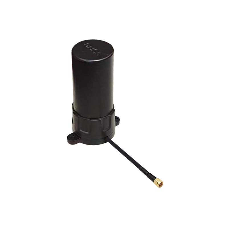
Antenna
|
FPC
|
FPC
|
|
3
|
Antenna Dimensions
|
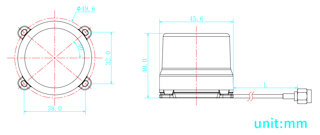
Φ45.6*40mm
|
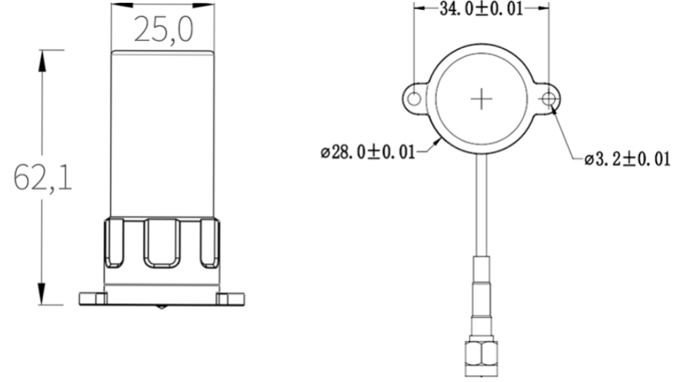
Φ62.1*25mm
|
|
4
|
Product Weight
|
25.8g
|
25.4g
|
|
5
|
Coaxial line
|
RG316 / RG1.13(customizable)
|
RG316 / RG1.13(customizable)
|
|
6
|
Line length
|
L=150mm / L=250mm(customizable)
|
L=150mm / L=250mm(customizable)
|
|
7
|
RF Output Interface
|
SMA-J / IPEX / MCX / MMCX(customizable)
|
SMA-J / IPEX / MCX / MMCX(customizable)
|
|
8
|
Antenna Housing
|
ABS+PC
|
ABS+PC
|
|
9
|
PCB Board
|
FR4
|
FR4
|
|
Environmental
Characteristics
|
1
|
Operating Temperature
|
-40℃~+85℃, 10%~95% RH
|
-40℃~+85℃, 10%~95% RH
|
|
2
|
Storage Temperature
|
-40℃~+85℃, 10%~95% RH
|
-40℃~+85℃, 10%~95% RH
|
|
3
|
Humidity
|
Sine sweep
@1.5mmAM 10~55Hz each Axis
|
Sine sweep
@1.5mmAM 10~55Hz each Axis
|
|
4
|
Vibration Resistance
|
95% No-condensing
|
95% No-condensing
|
丨 product mix
AK993/994:
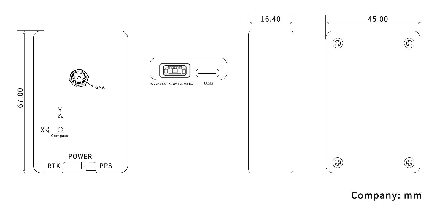
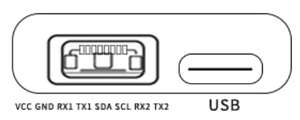
Table 1 PIN Foot Function
|
NO.
|
Pin Name
|
describe
|
|
1
|
VCC
|
The power input pin provides the necessary voltage for the device to operate
|
|
2
|
GND
|
Ground pin
|
|
3
|
RX1
|
The receiving end of serial interface 1 is used to receive data sent by external devices through serial port 1.
|
|
4
|
TX1
|
The transmitting end of serial interface 1 is used to send data to external devices through serial port 1.
|
|
5
|
SDA
|
The data pin of the I ² C bus is responsible for data transmission in I ² C communication.
|
|
6
|
SCL
|
The clock pin of the I ² C bus provides a clock signal for synchronous data transmission in I ² C communication.
|
|
7
|
RX2
|
The receiving end of serial interface 2 is used to receive data sent by external devices through serial port 2.
|
|
8
|
TX2
|
The transmitting end of serial interface 2 is used to send data to external devices through serial port 2.
|
AK159:
AK179:
AK181:
AK161:
Packaging and Delivery:

AK993 High-Precision GNSS RTK Board
Product Overview
The AK993 is a multi-band, multi-system GNSS board designed for centimeter-level accuracy, supporting GPS, BDS, GLONASS, and Galileo. This powerful RTK solution is ideal for high-precision positioning tasks such as UAV navigation, smart agriculture, surveying, mapping, and autonomous driving.
High-Frequency RTK Positioning Engine
Equipped with a high-performance RTK engine, the AK993 provides real-time differential correction and stable GNSS data in various terrains. Whether installed on drones or agricultural machinery, it ensures precise position tracking.
Optimized for Integration Applications
The AK993 is compatible with various open-source systems and industrial standard interfaces, supporting flexible deployment and long-term scalability. It is an ideal choice for developers and system integrators seeking a stable, high-precision positioning module.
Reliable Operation in Complex Environments
With excellent anti-interference capability and high signal sensitivity, the AK993 performs reliably in urban areas, mountainous regions, or environments with tree cover, providing dependable positioning output for real-world applications.
Product Advantages
-
Multi-band GNSS support for higher positioning accuracy
-
Optimized design for easy system integration and secondary development
-
Stable performance in harsh environments, adaptable to various application scenarios
-
Excellent performance and low power consumption, suitable for mobile platforms such as drones
Need high-precision positioning for UAV or agricultural systems? Choose DALANG AK993 GNSS board to enhance your project’s positioning accuracy with real-time RTK performance.
About Us
DALANG is a dedicated manufacturer of high-performance GNSS modules and RTK positioning solutions, serving industries such as UAV navigation, precision agriculture, and geospatial mapping. With a clear focus on accuracy, reliability, and integration flexibility, we support both standard and custom applications across global markets. Our product lines are engineered to meet the evolving demands of real-time positioning with support for multiple GNSS constellations, including GPS, GLONASS, BDS, and Galileo.
Our production facility spans 2,500㎡ and includes advanced SMT lines, in-house R&D labs, and full functional testing for every unit shipped. With a team of 30+ GNSS engineers, we design and manufacture over 200,000 GNSS receivers and modules annually. Certified to ISO9001:2015, and compliant with CE and RoHS standards, we follow a strict quality assurance process from prototyping through mass production. We also provide firmware updates, system integration support, and full lifecycle product documentation.
Trusted by partners in over 30 countries, DALANG delivers fast, scalable manufacturing with personalized technical support. Our streamlined collaboration model—covering inquiry, consultation, prototyping, and delivery—ensures efficiency from first contact to deployment. Whether you're sourcing off-the-shelf GNSS hardware or launching a customized solution, DALANG is your dependable partner for accurate, cost-effective positioning systems.
FAQ
1. Who are we?
We are DALANG, a specialized manufacturer of GNSS modules and RTK positioning systems based in China, with a focus on high-precision solutions for UAVs, surveying, and smart agriculture.
2. How can we guarantee quality?
All products undergo strict multi-stage quality control, including SMT production, functional testing, and 100% final inspection. We are ISO9001:2015 certified and follow international compliance standards such as CE and RoHS.
3. What can you buy from us?
You can purchase GNSS receivers, RTK modules, base stations, antennas, flight control positioning systems, and other GNSS-related components and accessories.
4. Why should you buy from us not from other suppliers?
We combine strong in-house R&D, flexible OEM/ODM support, industrial-grade quality assurance, and fast global delivery. Our expertise in GNSS RTK ensures stable, accurate, and scalable solutions tailored to your specific use case.
5. What services can we provide?
We offer OEM/ODM customization, technical consulting, firmware support, prototyping, and global after-sales service. Our team works closely with international clients to ensure efficient communication and long-term support.


