 丨 Product Introduction
1. Base station or roaming vehicle configuration: Provides high flexibility for different scenarios.
2. Differential positioning and vector attitude measurement: providing accurate position and direction.
3. Compatibility with flight control systems: Integration with Pixhawk and APM.
4. Four mode RTK: Ensure fast and accurate positioning in various environments.
丨 Specification parameters
|
Chip
characteristics
|
chip
|
UM982
|
|
Working mode
|
BDS: B1I、B2I、B3I
GPS: L1C/A、L2P (Y)、L2C、L5
GLONASS: L1、L2
Galileo: E1、E5a、E5b
QZSS: L1、L2、L5
|
|
Receiving channel
|
1408 channel
|
|
Accuracy
|
Single point positioning (RMS)
|
Plane: 1.5m
|
|
Elevation: 2.5m
|
|
DGPS(RMS)
|
Plane: 0.4m
|
|
Elevation: 0.8m
|
|
RTK(RMS)
|
Flat: 0.8cm+1ppm
|
|
Elevation: 1.5cm+1ppm
|
|
Directional accuracy (RMS)
|
0.2 degrees/1m baseline
|
|
Time accuracy (RMS)
|
20 ns
|
|
Speed accuracy (RMS)
|
0.2 m/s
|
|
Observation accuracy (RMS)
|
BDS
|
GPS
|
GLONASS
|
Galileo
|
|
B1I/B1C/L1 C/A/E1/G1 pseudorange
|
10cm
|
10cm
|
10cm
|
10cm
|
|
B1I/B1C/ L1 C/A/E1/G1 Carrier Phase
|
1mm
|
1mm
|
1mm
|
1mm
|
|
B3I/L2P(Y)/L2C/G2 pseudorange
|
10cm
|
10cm
|
10cm
|
10cm
|
|
B3I/L2P(Y)/L2C/G2 Carrier Phase
|
1mm
|
1mm
|
1mm
|
1mm
|
|
B2I/ L5/E5a/E5b pseudorange
|
10cm
|
10cm
|
10cm
|
10cm
|
|
B2I/ L5/E5a/E5b Carrier Phase
|
1mm
|
1mm
|
1mm
|
1mm
|
|
Time To First
Fix TTFF
|
cold boot
|
<20s
|
|
Initialization time
|
<5s ( Typical values)
|
|
Initialize reliability
|
>99.9%
|
|
Output data
|
Baud rate
|
115200bps (default) [Optional: 4800-921600]
|
|
Output interface
|
TTL/USB
|
|
Output Protocol
|
NMEA0183、RTCM 3.3
|
|
Data update rate
|
1Hz-20Hz (default 1Hz)
|
|
Differential data
|
RTCM 3.3/3.2/3.1/3.0
|
|
Carrier phase output
|
Support, output RAWX statement
|
|
FLASH
|
built-in
|
|
Electrical
specifications
|
working voltage
|
3~5.5V DC
|
|
power waste
|
<800mW
|
|
Physical
parameters
|
size
|
58*40mm*11mm
|
|
weight
|
12g
|
|
Connector
|
TYPE-C/ GH1.25mm 4pin*2
|
|
Antenna connector
|
SMA-J straight head * 2
|
|
Environment
|
working temperature
|
-35℃-80℃
|
|
Storage temperature
|
-40℃-85℃
|
|
compass
|
compass
|
IST8310
|
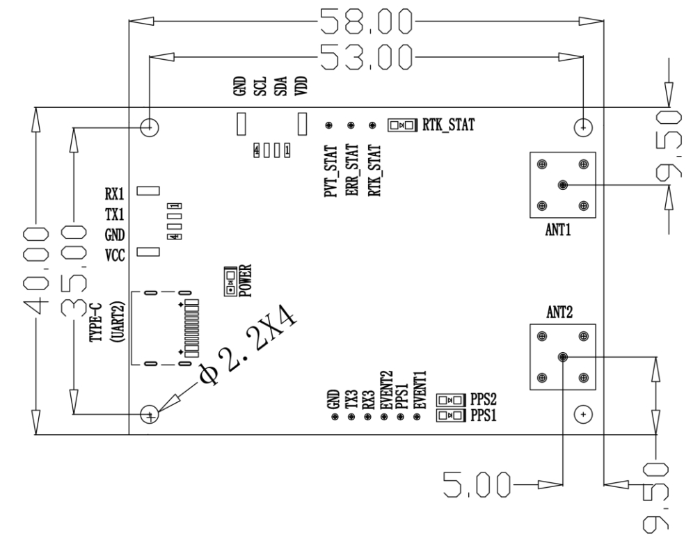
Table 1 PIN Functionality
|
Left Panel
|
1
|
RX1
|
Serial Port 1 Receive
|
|
2
|
TX1
|
Serial Port 1 Transmit
|
|
3
|
GND
|
Ground
|
|
4
|
VCC
|
Power Supply
|
|
Power and Communication Interface
|
TYPE-C (UART2)
|
Type-C USB interface supporting UART communication
|
|
POWER
|
Power Indicator
|
|
Right Panel
|
1
|
ANTX1
|
GNSS Antenna Signal Input (Main Antenna)
|
|
2
|
ANTX2
|
GNSS Antenna Signal Input (Auxiliary Antenna)
|
|
Top Panel
|
1
|
VDD
|
Power for Geomagnetic Chip
|
|
2
|
SDA
|
I2C Data
|
|
3
|
SCL
|
I2C Clock
|
|
4
|
GND
|
Ground
|
|
5
|
PVT-STAT
|
PVT Positioning Indicator, active high. Outputs high level when the module can position, low level when not positioning.
|
|
6
|
ERR-STAT
|
Error Indicator, active high. Outputs high level when module self-check fails, low level when self-check passes.
|
|
7
|
RTK-STAT
|
RTK Positioning Indicator, active high. Outputs high level when RTK fixed solution is achieved. Outputs low level for other positioning statuses or no positioning.
|
|
Bottom Panel
|
1
|
EVENT1
|
Event Trigger 1
|
|
2
|
PPS1
|
Pulse Per Second 1
|
|
3
|
EVENT2
|
Event Trigger 2
|
|
4
|
RX3
|
Serial Port 3 Receive
|
|
5
|
TX3
|
Serial Port 3 Transmit
|
|
6
|
GND
|
Ground
|
|
7
|
PPS1
|
Pulse Per Second 1
|
|
8
|
PPS2
|
Pulse Per Second 2
|
Table 2 Interface Characteristics
|
No.
|
Name
|
Symbol
|
Min
|
Typical
|
Max
|
Unit
|
|
1
|
Main Power Supply
|
Vcc
|
2.7
|
3.3
|
5.0
|
V
|
|
2
|
RF Port Feeding
|
VRF
|
3.0
|
3.1
|
3.3
|
V
|
|
3
|
Input High Level
|
VIH
|
2.0
|
|
|
V
|
|
4
|
Input Low Level
|
VIL
|
|
|
0.7
|
V
|
|
5
|
Output High Level
|
VOH
|
3.2
|
|
|
V
|
|
6
|
Output Low Level
|
VOL
|
|
|
0.1
|
V
|
|
7
|
Main Serial Baud RateBaud
|
Baud
|
|
115200
|
|
bps
|
|
8
|
Differential Wave
|
Baud
|
|
115200
|
|
bps
|
High-Precision GNSS RTK for Professional Applications
The DALANG UM982 RTK module offers full-system, full-frequency satellite tracking across GPS, BDS, GLONASS, and Galileo. Designed for centimeter-level accuracy, this industrial-grade GNSS RTK module ensures stable performance for precision agriculture, UAV, and surveying tasks.
Dual-Antenna Orientation for Accurate Heading
Featuring dual-antenna directional calculation, the UM982 provides real-time heading data with high stability. This makes it ideal for UAV autopilot systems and autonomous navigation where precise direction is critical. A professional-grade RTK GPS solution that offers not only positioning, but orientation confidence.
Engineered for UAV and Agricultural Automation
Built to integrate seamlessly into UAV systems and farm machinery, this RTK module enables autonomous path planning, terrain mapping, and automated steering. If you’re deploying a smart farming solution or drone-based survey platform, this GNSS RTK system delivers consistent centimeter-level control.
Compact GPS Board with Industrial Reliability
The UM982 is a compact, durable GPS board with advanced anti-interference capabilities. It supports high update rates and is optimized for integration into open-source and proprietary platforms. Whether you're upgrading your fleet or developing a new platform, this RTK GPS module provides scalable precision.
Product Advantages
Full-Frequency GNSS RTK Accuracy
The UM982 RTK module supports multi-band, full-system GNSS RTK tracking for sub-inch accuracy. It’s a professional tool for users who require dependable RTK GPS solutions for precision-based industries.
Dual-Antenna Directional Output
With its built-in directional calculation, the module is perfect for autopilot systems requiring both location and heading. Ideal for UAVs, robotics, and agricultural vehicles, this RTK module ensures precise directional awareness.
Compact and Powerful GPS Board Design
This rugged GPS board offers advanced filtering and fast signal acquisition. Whether installed in drones or autonomous farm equipment, this RTK GPS board provides industrial performance in a compact footprint.
Seamless Autopilot and UAV Integration
Fully compatible with open-source flight control systems, this GNSS RTK module is ready for real-world deployment. For developers and aerial solution providers, it’s the ideal RTK module for long-term reliability.
Need centimeter-level precision and real-time heading for UAV or agriculture? Order the DALANG UM982 RTK module today and take control of your autonomous systems with unmatched accuracy.
About Us
DALANG is a dedicated manufacturer of high-performance GNSS modules and RTK positioning solutions, serving industries such as UAV navigation, precision agriculture, and geospatial mapping. With a clear focus on accuracy, reliability, and integration flexibility, we support both standard and custom applications across global markets. Our product lines are engineered to meet the evolving demands of real-time positioning with support for multiple GNSS constellations, including GPS, GLONASS, BDS, and Galileo.
Our production facility spans 2,500㎡ and includes advanced SMT lines, in-house R&D labs, and full functional testing for every unit shipped. With a team of 30+ GNSS engineers, we design and manufacture over 200,000 GNSS receivers and modules annually. Certified to ISO9001:2015, and compliant with CE and RoHS standards, we follow a strict quality assurance process from prototyping through mass production. We also provide firmware updates, system integration support, and full lifecycle product documentation.
Trusted by partners in over 30 countries, DALANG delivers fast, scalable manufacturing with personalized technical support. Our streamlined collaboration model—covering inquiry, consultation, prototyping, and delivery—ensures efficiency from first contact to deployment. Whether you're sourcing off-the-shelf GNSS hardware or launching a customized solution, DALANG is your dependable partner for accurate, cost-effective positioning systems.
FAQ
What kind of GNSS constellations does your module support?
Our UM982 module supports multiple GNSS constellations, including GPS, BDS, GLONASS, Galileo, and QZSS. This full-system, full-frequency coverage ensures robust and reliable positioning in diverse environments, ideal for UAV and precision navigation applications.
Can I integrate the UM982 module with my existing autopilot system?
Yes, our module is designed for seamless UAV integration and works with popular flight controllers like Pixhawk and APM. It delivers real-time centimeter-level RTK positioning and heading data, enhancing autopilot accuracy and stable autonomous flight.
Do you offer customization or OEM services for your GNSS receivers?
We provide flexible OEM/ODM customization including firmware support, hardware adjustments, and system integration. Whether you need tailored GNSS receivers or specialized RTK modules, our team works closely with you to meet your specific project needs.
What are the electrical and interface specifications of the UM982 module?
The UM982 operates on 3–5.5 V DC and supports TTL or USB interfaces with default 115200 bps output. It uses standard protocols like NMEA0183 and RTCM 3.3 for easy connection and communication with your UAV’s navigation system or GPS module setup.