Product Advantages
Engineered Design Meets Integration and Environmental Challenges
Constructed with a rugged ABS radome and built to withstand temperature extremes from -40°C to 85°C, the AK715 GNSS antenna offers a structurally sound solution optimized for outdoor and industrial use. Its multi system GNSS antenna architecture supports full band coverage across GPS, GLONASS, Galileo, and BeiDou, enhancing signal acquisition resilience. The compact dimensions and lightweight design facilitate easy installation across diverse platforms, from UAVs to fixed surveying instruments. Additionally, the broad input voltage range and standardized 50 Ω impedance ensure compatibility with a wide array of receivers and RTK surveying antenna systems to streamline integration without requiring complex adapters.
Optimized Performance Delivers Precision and Operational Simplicity
Users benefit from the antenna’s high gain and low-noise amplification, which produces consistent centimeter-level accuracy critical for RTK surveying antenna procedures. The device’s stable phase center and front-to-back ratio reduce signal multipath effects, improving measurement reliability in urban and industrial environments. This high precision GNSS antenna features user-friendly characteristics such as compact size, low power consumption, and robust anti-interference capabilities, translating into hassle-free operation and dependable data output for extended field sessions. These performance advantages allow professionals to increase productivity while maintaining the accuracy demanded by modern geospatial projects.
丨 Product IntroductionAK715 supports multiple frequency bands of multiple satellite systems such as GPS, GLONASS, Galileo, and Beidou. It has the characteristics of multi band reception, high gain, low noise, strong anti-interference, miniaturization, and good weather resistance. It is widely used in fields such as surveying and mapping, construction, autonomous driving, unmanned aerial vehicles, and ocean exploration, providing centimeter level and even millimeter level high-precision positioning services for these industries.
characteristic:
1. High precision: Based on the principle of carrier phase observation difference, it can achieve centimeter or even millimeter level positioning accuracy, meeting the extremely high requirements for position accuracy in application scenarios.
2. Multi band compatibility: It can support signal reception in multiple frequency bands of multiple satellite systems such as GPS, GLONASS, Galileo, and Beidou, enhancing signal acquisition capabilities and improving positioning reliability and stability.
3. Strong anti-interference ability: It has good anti-interference ability and can still stably receive signals in complex electromagnetic environments, such as high-rise areas in cities, industrial plants, etc., ensuring the normal operation of positioning functions.
4.High gain: can effectively enhance signal strength, even in weak signal environments, clear satellite signals can be obtained, ensuring the accuracy and timeliness of positioning.
丨 Specification parameters
|
Specification parameters
|
|
Antenna
characteristics
|
1
|
Usage frequency
|
GPS: L1, L2, L5
BDS: B1I, B2I, B3I, B2a, B2b
GLONASS: L1, L2, L3
Galileo: E1, E5b, E5a, E6
QZSS: L1, L2, L5, L6
IRNSS: L5
|
|
2
|
Antenna specifications
|
GPS,BDS,GLONASS,GALILEO,QZSS
|
|
3
|
V. S.W.R (standing wave ratio)
|
≤2.0
|
|
4
|
Axial ratio
|
Elevation angle of 90 degrees: ≤ 3, elevation angle of 15 degrees: ≤ five
|
|
5
|
Gain
|
Elevation angle of 90 degrees: ≥ 6, elevation angle of 20 degrees: ≥ 0 plane)
|
|
6
|
Front to back ratio
|
± 60 degrees ≥ 15dB
|
|
7
|
Phase center (mm)
|
<2
|
|
8
|
impedance
|
50Ω
|
|
9
|
Polarization mode
|
RHCP
|
|
LNA
|
1
|
LNA gain
|
36±2dB
|
|
2
|
V. S.W.R
|
<2
|
|
3
|
figure
|
<2.0
|
|
4
|
dc power
|
3.3~12V
|
|
5
|
Working current
|
25~40mA
|
|
Mechanical
structure
|
1
|
Radome material
|
ABS
|
|
2
|
Antenna size
|
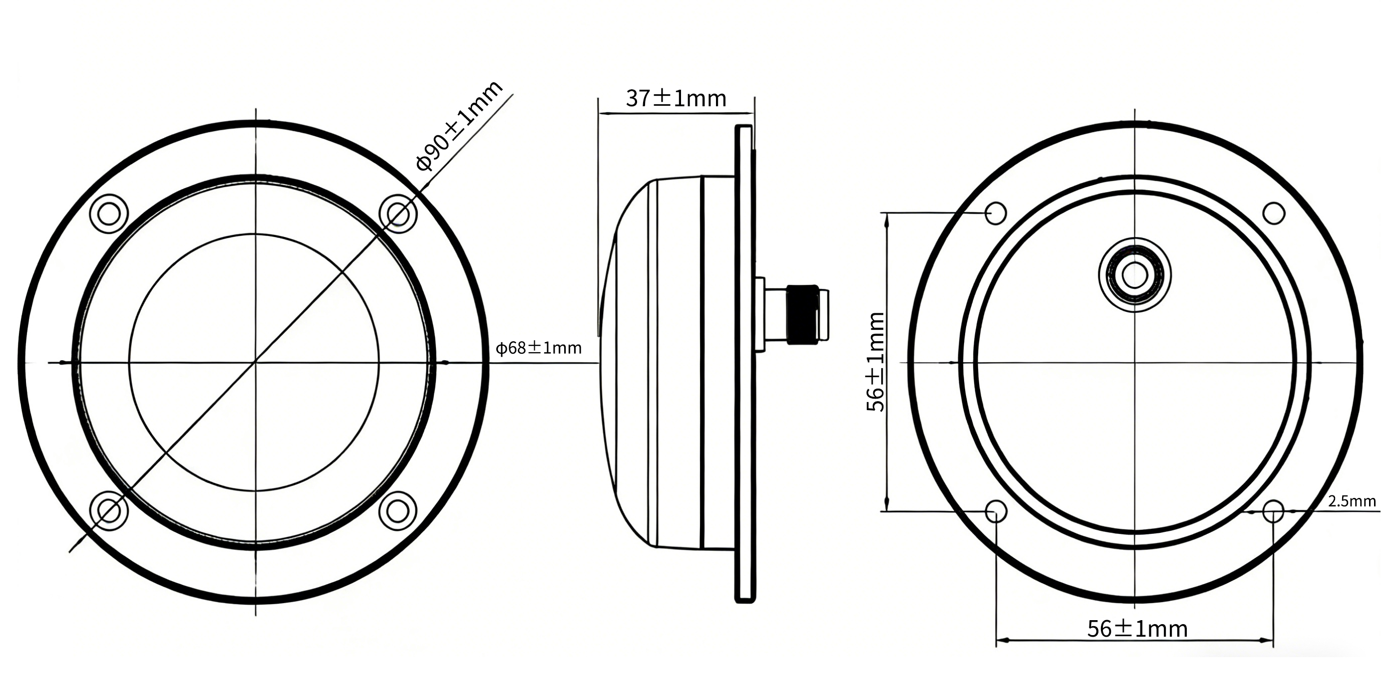
φ90*37mm(Excluding connectors)
|
|
3
|
Product weight
|
186g
|
|
4
|
joint
|
TNC-K
|
|
Environmental
|
1
|
operation temperature
|
-40℃~+85℃, 10%~95% RH
|
|
2
|
storage temperature
|
-55℃~+100℃, 10%~95% RH
|
|
3
|
vibrate
|
Sine sweep frequency @ 1.5mmAM, 10~55Hz per axis
|
Packaging and Delivery:

Use Scenarios
Precise Land Surveying and Construction Site Control
Within the civil engineering and land surveying industries, the AK715 GNSS antenna integrates into RTK surveying antenna setups to provide centimeter-level positioning essential for boundary delineation, topographic mapping, and machine control. Its multi system GNSS antenna functionality ensures stable satellite tracking in built-up areas and challenging terrains, helping field engineers perform real-time data collection with high confidence. Compatible with standard RTK equipment, this antenna enhances operational workflows by delivering accurate coordinate data essential for project planning, construction staking, and quality assurance processes, thereby reducing errors and accelerating on-site decision making.
Advanced UAV and Agricultural Precision Applications
Deployed in precision agriculture and UAV navigation, the AK715 high precision GNSS antenna supports reliable position fixing fundamental for crop monitoring, field mapping, and autonomous drone guidance. Its multi constellation capability guarantees continuous satellite reception even in obstructed environments such as tree-lined fields or remote rural areas. The antenna’s compact and lightweight design allows easy mounting on aerial platforms, improving drone flight stability and mapping accuracy. By integrating with GNSS RTK correction services, it ensures optimal data synchronization required for variable rate application and terrain modeling, ultimately driving higher crop yields and resource efficiency.
FAQ
What features make the AK715 GNSS antenna suitable for precise surveying?
Our AK715 GNSS antenna supports multi-band and multi-system constellations like GPS, GLONASS, and Beidou to ensure centimeter-level accuracy. It has a high gain, low noise design, and robust anti-interference performance, making it ideal for demanding RTK surveying antenna applications in challenging environments.
Can you customize the GNSS antennas for specific projects or industries?
Yes, we offer OEM/ODM services for our GNSS products, allowing customization to fit your project's requirements. Whether you need tailored firmware, specific connectors, or integration support, our team works closely with you to deliver a solution that meets precision and compatibility needs.
How do I install the AK715 antenna on my drone or machinery?
Our high precision GNSS antenna comes in a compact, rugged design that is easy to mount on aerial, marine, or land platforms. The antenna’s 50-ohm impedance and wide power input make it compatible with most GNSS receivers. We provide detailed documentation and technical support to guide your installation process.
What quality controls ensure the reliability of your GNSS antennas?
We follow a strict quality assurance process including SMT production, in-house functional testing, and final inspection for every unit. Our facilities are ISO9001:2015 certified and comply with CE and RoHS standards, guaranteeing stable performance and durability of our RTK surveying antenna and other products.