Precision and Reliability for Professional UseThe DALANG RTK GPS receiver is designed for high-precision applications where accurate positioning is critical. Whether you’re in engineering, surveying, or agriculture, this module delivers centimeter-level accuracy by utilizing advanced GNSS technology. The GNSS base station integration allows for real-time corrections, ensuring precise location data. Ideal for systems that rely on RTK GPS and require robust and reliable navigation, this module works seamlessly with NTRIP for efficient data communication. The module supports multiple satellite constellations, including GPS, Beidou, Galileo, and GLONASS, providing superior coverage and performance even in challenging environments.High-End Features and Technical SpecificationsEquipped with advanced technology, the DALANG RTK receiver operates at a high refresh rate, ensuring real-time data updates for smooth positioning and control. It supports NTRIP (Networked Transport of RTCM via Internet Protocol) for improved accuracy and faster response times. This makes it highly suitable for integration into autopilot systems, where accurate navigation is crucial. The module is fully compatible with various GNSS systems, providing flexibility in its application for industrial, surveying, and agricultural uses. With built-in Bluetooth and 4G connectivity, it ensures seamless communication between the base station and field equipment, improving operational efficiency.Wide Range of Applications and Use CasesThe DALANG GNSS receiver for sale module is ideal for a broad range of industries, including autonomous vehicles, UAVs, and professional surveying equipment. In agriculture, it assists with precision farming by providing accurate field data for monitoring crops and soil conditions. In construction and civil engineering, the GNSS base station ensures precise measurements for project planning and monitoring. Additionally, the module’s ability to integrate with autopilot systems enables precise navigation for drones, making it a versatile choice for professionals who demand accuracy and reliability in their operations.丨 Product Introduction
1.Support full constellation multi frequency chip level RTK positioning and dual antenn a heading solutions.
2.Supports BDS, GPS, GLONASS, Galileo, QZSS, and SBAS.
3.The terminal supports Ntrip communication protocol and supports network base stati on services such as Chihiro location, CORS stations, and self built stations.
4.Adopt on - board standard 9 - 36V wide voltage input.
Product AdvantagesCompact and Integrated DesignThe DALANG RTK GPS receiver features a compact, all-in-one design, integrating multiple GNSS systems and NTRIP communication capabilities into a single unit. This integration simplifies installation, reducing the need for additional components and ensuring a streamlined setup. The module’s lightweight design makes it easy to integrate into existing systems without compromising performance, offering enhanced portability for field use.Full Multi-Constellation SupportThe DALANG RTK receiver supports GPS, Beidou, Galileo, and GLONASS constellations, providing extensive coverage and ensuring more reliable and accurate positioning across different geographic regions. This multi-constellation support helps improve the module’s performance, particularly in environments where traditional GPS signals may be weak or obstructed. The enhanced coverage ensures continuous, reliable data, even in urban environments or areas with limited satellite visibility.Seamless Integration with Autopilot SystemsThe DALANG GNSS base station module is designed for seamless integration with autopilot systems, offering precision positioning for unmanned vehicles. Whether for drones or autonomous ground vehicles, the module provides the necessary data for accurate navigation, improving the efficiency and safety of autonomous systems. This integration is crucial for industries that rely on autonomous systems for mapping, surveying, or inspections.Flexible Connectivity OptionsThe GNSS receiver for sale module is equipped with Bluetooth and 4G connectivity, offering versatile communication options for both remote and local data transmission. This flexibility ensures that the module can easily connect with other devices and systems in the field, facilitating efficient data transfer for real-time decision-making. Whether operating in a connected environment or remote area, the module ensures uninterrupted communication, which is critical for precision-based applications.丨 Specification parameters
|
Specification parameters
|
|
GNSS module
|
1
|
Working mode
|
BDS: B1I、B2I、B3I
GPS: L1C/A、L2P (Y)、L2C、L5
GLONASS: L1、L2
Galileo: E1、E5a、E5b
QZSS: L1、L2、L5
|
|
2
|
Receiving channel
|
1408 channel
|
|
3
|
Single point positioning (RMS)
|
Plane: 1.5m
|
|
Elevation: 2.5m
|
|
4
|
DGPS(RMS)
|
Plane: 0.4m+1ppm
|
|
Elevation: 0.8m+1ppm
|
|
5
|
RTK(RMS)
|
Flat: 0.008m+1ppm
|
|
Elevation: 0.015m+1ppm
|
|
6
|
Directional accuracy (RMS)
|
0.2degrees/1m baseline
|
|
7
|
Time accuracy (RMS)
|
20ns
|
|
8
|
Speed accuracy (RMS)
|
0.03m/s
|
|
9
|
Observation accuracy (RMS)
|
BDS
|
GPS
|
GLONASS
|
Galileo
|
|
10
|
B1I/B1C/L1 C/A/E1/G1 pseudorange
|
10cm
|
10cm
|
10cm
|
10cm
|
|
11
|
B1I/B1C/L1 C/A/E1/G1 carrier phase
|
1mm
|
1mm
|
1mm
|
1mm
|
|
12
|
B3I/L2P (Y)/L2C/G2 pseudorange
|
10cm
|
10cm
|
10cm
|
10cm
|
|
13
|
B3I/L2P (Y)/L2C/G2 carrier phase
|
1mm
|
1mm
|
1mm
|
1mm
|
|
14
|
B2I/L5/E5a/E5b pseudorange
|
10cm
|
10cm
|
10cm
|
10cm
|
|
15
|
B2I/L5/E5a/E5b carrier phase
|
1mm
|
1mm
|
1mm
|
1mm
|
|
16
|
cold boot
|
<30s
|
|
17
|
Initialization time
|
<5s (typical value)
|
|
4G module (network frequency band)
|
1
|
LTE FDD
|
B1/3/7/8/20/28
|
|
2
|
LTE TDD
|
B38/40/42/43
|
|
3
|
GSM/GPRS/EDGE
|
NA
|
|
4G module (propagation speed)
|
1
|
LTE FDD (Mbps)
|
10.3(DL)/5.1(UL)
|
|
2
|
LTE TDD (Mbps)
|
9.1(DL)/3.1(UL)
|
|
Bluetooth
module
|
1
|
Bluetooth version
|
2.0
|
|
2
|
Working frequency band
|
2.4G
|
|
3
|
Air speed
|
2Mbps
|
|
4
|
Reference distance
|
10m
|
|
Data format
|
1
|
Differential data
|
RTCM3.X
|
|
2
|
output format
|
NMEA-0183, RTCM3.X
|
|
3
|
Data update rate
|
1Hz-20Hz(default 1Hz)
|
|
Power supply
|
1
|
Voltage
|
DC +9V~36V
|
|
2
|
power waste
|
<3W
|
|
3
|
Working current
|
≤145mA/12V
|
|
4
|
indicator light
|
1 NET,1RTK,1BT
|
|
Physical
parameters
|
1
|
size
|
100mm*61.8mm*18.75mm
|
|
2
|
weight
|
180g
|
|
3
|
Shell material
|
aluminium
|
|
4
|
interface
|
SMA*3/8-core LEMO ports
|
|
Environmental Specifications
|
1
|
working temperature
|
-30℃~+70℃
|
|
2
|
Storage temperature
|
-40℃~+85℃
|
|
3
|
humidity
|
95% condensation
|
|
4
|
Protection grade
|
IP65
|
|
5
|
Seismic resistance
|
Resist the impact of a 1-meter free fall
|
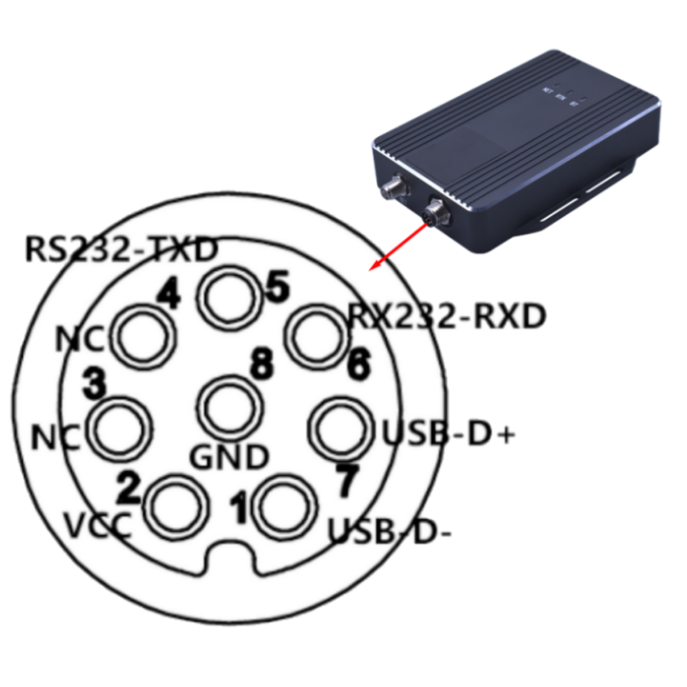
Table 1 M8 Interface Definition
|
Serial Number
|
Interface Name
|
Function Introduction
|
|
1
|
USB-D-
|
Parameter configuration USB interface D-
|
|
2
|
VCC
|
power input DC9-36V
|
|
3
|
NC
|
empty
|
|
4
|
NC
|
empty
|
|
5
|
RS232-TXD
|
RTK positioning output RS232-TXD
|
|
6
|
RS232-RXD
|
RTK positioning output RS232-RXD
|
|
7
|
USB-D+
|
Parameter configuration USB interface D+
|
|
8
|
GND
|
Grounding
|
|
Antenna interface
|
|
1
|
GNSS
|
Active positioning antenna, 3.3V, SMA interface
|
|
2
|
NET
|
4G antenna interface, SMA
|
Schematic diagram of connecting wires:
 Display of the complete set of solutions:
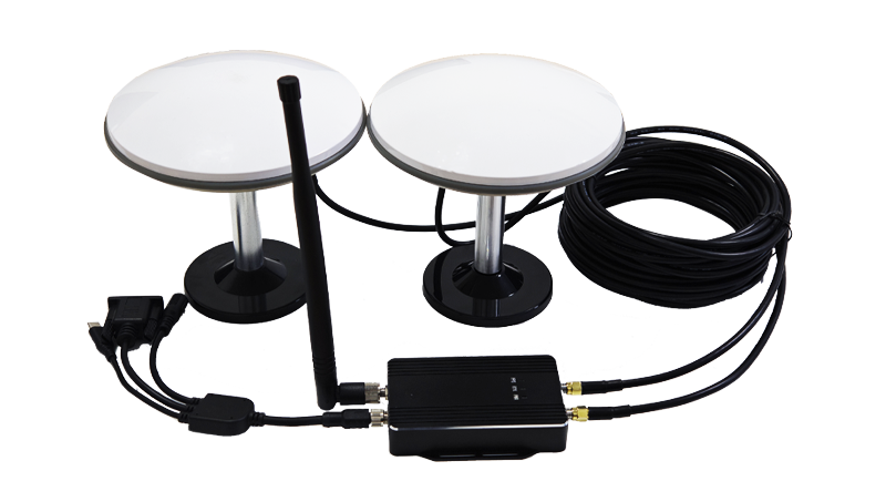
Table 2 Complete Component Description
|
Number
|
Name
|
Quantity
|
Remarks
|
|
1
|
AK988EU terminal
|
1
|
|
|
2
|
Connecting line
|
1
|
M8 aviation head to type C; DC-DC power supply; DB9 female head
|
|
3
|
GNSS antenna
|
2
|
Full system full frequency antenna
|
|
4
|
Coaxial line
|
2
|
5mTNC to SMA, 50-3 wires
|
|
5
|
4G antenna
|
1
|
|
antenna parameters:
  |
|
Electrical
Characteristics
|
1
|
Frequency Range
|
GPS: L1, L2, L5
BDS: B1I, B2I, B3I, B2a, B2b
GLONASS: L1, L2, L3
Galileo: E1, E5b, E5a, E6
QZSS: L1, L2, L5, L6
IRNSS: L5
L-BAND
|
|
2
|
Output Standing Wave
|
≤2.0
|
|
3
|
Antenna Axial Ratio
|
≤3dB
|
|
4
|
Maximum Gain
|
5.5dBi
|
|
5
|
Phase Center
|
±2mm
|
|
6
|
Impedance
|
50Ω
|
|
7
|
Polarization Mode
|
RHCP
|
|
LNA
Specifications
|
1
|
LNA
|
L1:38±2dB
L2:38±2dB
|
|
2
|
VSWR
|
≤2.0
|
|
3
|
Noise Figure
|
≤1.8dB
|
|
4
|
In-band Flatness
|
1dB
|
|
5
|
Operating Voltage
|
3.3~12V
|
|
6
|
Operating Current
|
≤45 mA
|
|
7
|
Differential Transmission Delay
|
≤5ns
|
|
Structural Characteristics
|
1
|
Antenna Size
|
Φ159*61mm
|
|
2
|
Weight
|
≤380g
|
|
3
|
Connector Type
|
TNC
|
|
4
|
Thread Specification
|
Unified National Coarse (UNC) 5/8''×11 (Imperial)
|
|
5
|
Mounting Method
|
centering rod mounting
|
|
Environmental Conditions
|
1
|
Operating Temperature
|
-40℃~+85℃
|
|
2
|
Storage Temperature
|
-55℃~+85℃
|
|
3
|
Humidity
|
95% non-condensing
|
  |
|
Antenna
Characteristics
|
1
|
Operating Frequency
|
GPS: L1C/A, L1C, L2P, L2C, L5
BDS-2: B1I, B21, B31
BDS-3: B1I, B31, B1C, B2a, B2b
GLONASS: G1, G2, G3
Galileo: E1, E5b, E5a, E5AltBoC, E6c
QZSS: L1C/A, L2C, L5, L1C
SBAS: L1C/A
IRNSS: L5
|
|
2
|
Antenna Specifications
|
GPS, Bei Dou,GLONASS,GALILEO
|
|
3
|
Frequency Range
|
1165-1278/1559-1612MHz
|
|
4
|
V.S.W. R
|
≤2.0
|
|
5
|
Axial Ratio
|
Elevation angle 90 degrees: ≤3
Elevation angle 15 degrees: ≤5
|
|
6
|
Gain
|
Elevation angle 90 degrees: ≥6
Elevation angle 20 degrees: ≥0 (plane)
|
|
7
|
Front to back power
|
±60 degrees: ≥15dB
|
|
8
|
Phase Center (mm)
|
<2
|
|
9
|
Impendence
|
50Ω
|
|
10
|
Polarization
|
RHCP
|
|
LNA
|
1
|
LNA GAIN
|
38±2dB
|
|
2
|
V.S.W. R
|
<2
|
|
3
|
Noise Figure
|
<1.5
|
|
4
|
DC Voltage
|
3.3~18V
|
|
5
|
Current
|
<35 mA
|
|
Mechanical
Structure
|
1
|
Component Name
|
SPEC
|
|
2
|
Antenna Connector
|
TNC / SMA
|
|
3
|
Antenna Dimensions
|
Φ120*38mm
|
|
4
|
weight
|
313.8g
|
|
5
|
PCB board
|
FR4
|
|
Environmental Characteristics
|
1
|
Operating Temperature
|
-40℃~+85℃, 10%~95% RH
|
|
2
|
Storage Temperature
|
-55℃~+100℃, 10%~95% RH
|
|
3
|
Vibration
|
Sine sweep @1.5mmAM
10~55Hz each Axis
|
|
picture
|
1
|
picture
|

|

|
|
Electrical
Characteristics
|
1
|
Operating Frequency
|
GPS: L1, L2, L5
BDS: B1I, B2I, B3I, B2a, B2b
GLONASS: L1, L2, L3
Galileo: E1, E5b, E5a, E6
QZSS: L1, L2, L5, L6
IRNSS: L5
|
GPS: L1, L2, L5
BDS: B1I, B2I, B3I, B2a, B2b
GLONASS: L1, L2, L3
Galileo: E1, E5b, E5a, E6
QZSS: L1, L2, L5, L6
IRNSS: L5
|
|
2
|
Frequency Range
|
1170-1278/1559-1612MHz
|
1170-1278/1559-1612MHz
|
|
3
|
V.S.W. R
|
≤2.0
|
≤2.0
|
|
4
|
Axial Ratio
|
Elevation at 90 degrees: ≤ 3,
Elevation at 15 degrees: ≤ 5
|
At elevation angle 90 degrees:
≤3, at elevation angle 15 degrees: ≤5
|
|
5
|
Gain
|
Elevation at 90 degrees: ≥ 6 dB,
Elevation at 20 degrees: ≥ 0 dB
|
At an elevation angle of 90 degrees:
≥6, at an elevation angle of 20 degrees: ≥0 plane
|
|
6
|
Phase Center
|
<2mm
|
<2
|
|
7
|
Impendence
|
50Ω
|
50Ω
|
|
8
|
Polarization
|
RHCP
|
RHCP
|
|
9
|
Out-of-Band Suppression
|
1268+100MHZ≥50db,
1170-100MHZ≥50db,
1602+100MHZ≥50db,
1561-100MHZ ≥50db.
|
1268+100MHZ≥50db,
1170-100MHZ≥50db,
1602+100MHZ≥50db,
1561-100MHZ ≥50db.
|
|
LNA
|
1
|
LNA GAIN
|
38±2dB
|
38±2dB
|
|
2
|
V.S.W. R
|
<2
|
<2
|
|
3
|
Noise Figure
|
<2.0
|
<2.0
|
|
4
|
DC Voltage
|
3.3~16V
|
3.3~16V
|
|
5
|
Current
|
<35 mA
|
<35 mA
|
|
Mechanical
Structure
|
1
|
Part Name
|
SPEC
|
SPEC
|
|
2
|
Antenna
|
FPC
|
FPC
|
|
3
|
Antenna Dimensions
|
Φ45.6*40mm
|
Φ62.1*25mm
|
|
4
|
Product Weight
|
25.8g
|
25.4g
|
|
5
|
Coaxial line
|
RG316 / RG1.13(customizable)
|
RG316 / RG1.13(customizable)
|
|
6
|
Line length
|
L=150mm / L=250mm(customizable)
|
L=150mm / L=250mm(customizable)
|
|
7
|
RF Output Interface
|
SMA-J / IPEX / MCX / MMCX(customizable)
|
SMA-J / IPEX / MCX / MMCX(customizable)
|
|
8
|
Antenna Housing
|
ABS+PC
|
ABS+PC
|
|
9
|
PCB Board
|
FR4
|
FR4
|
|
Environmental
Characteristics
|
1
|
Operating Temperature
|
-40℃~+85℃, 10%~95% RH
|
-40℃~+85℃, 10%~95% RH
|
|
2
|
Storage Temperature
|
-40℃~+85℃, 10%~95% RH
|
-40℃~+85℃, 10%~95% RH
|
|
3
|
Humidity
|
Sine sweep
@1.5mmAM 10~55Hz each Axis
|
Sine sweep
@1.5mmAM 10~55Hz each Axis
|
|
4
|
Vibration Resistance
|
95% No-condensing
|
95% No-condensing
|
AK181:

AK161:

About Us
DALANG is a leading provider of innovative GNSS and RTK solutions for a wide range of industries, including surveying, agriculture, construction, and autonomous systems. With a focus on high-precision technology, DALANG designs and manufactures products that offer reliable and accurate positioning for various professional applications. We are committed to providing cutting-edge solutions that enhance operational efficiency, accuracy, and safety. Our products are trusted by industry professionals around the world for their durability, accuracy, and ease of integration with existing systems. At DALANG, we pride ourselves on delivering exceptional customer service and technical support, ensuring that our clients achieve success with our products.
Contact us today to learn more about how our RTK GPS receiver can enhance your surveying or autonomous navigation systems!
FAQ
How do I install the DALANG GNSS receiver module?
The RTK GPS receiver module is easy to integrate with existing systems. It connects via Bluetooth or 4G, with clear installation guidelines provided for smooth setup.
What is the accuracy of the RTK receiver module?
The DALANG RTK GPS receiver provides centimeter-level accuracy, ideal for high-precision applications such as surveying, construction, and autonomous vehicle navigation.
Can this module be used for autopilot systems?
Yes, the DALANG GNSS base station module is fully compatible with autopilot systems, providing precise navigation and positioning for drones and unmanned vehicles.
What is NTRIP, and how does it benefit the module?
NTRIP (Networked Transport of RTCM via Internet Protocol) provides real-time corrections, improving the positioning accuracy of the GNSS receiver for sale module, especially in remote areas.
Is technical support available for this product?
Yes, DALANG provides comprehensive technical support for the RTK GPS receiver, including setup assistance, troubleshooting, and optimization to ensure smooth performance.