丨Product Introduction
Product Advantages
Compact & Integrated Design
The DALANG RTK GPS Module is engineered as a compact, all-in-one solution, integrating a GNSS receiver and an RTK positioning system into a single unit. This integration eliminates the need for additional hardware, ensuring effortless installation and reduced weight — a critical factor for lightweight UAVs. The compact form factor also saves space while maintaining high performance, making it suitable for a wide range of UAV platforms.
Centimeter-Level Accuracy & Multi-Constellation Support
Equipped with full-frequency coverage, the RTK Module supports multi-system GNSS, enabling UAVs to achieve centimeter-level positioning accuracy in any environment. It can access multiple satellite constellations including GPS, GLONASS, Galileo and BDS, delivering reliable positioning even in harsh environments such as urban canyons or dense forests. This multi-constellation support ensures consistent and precise navigation for all UAV missions, allowing operators to complete their work with confidence.
Low Power Consumption for Extended Operations
The DALANG UAV RTK Module is designed to minimize power consumption, enabling UAVs to operate for extended periods without compromising positioning accuracy. This is particularly advantageous for long-duration missions such as aerial surveying or environmental monitoring, where maintaining a stable GPS signal throughout the flight is essential. By reducing power draw, the module helps users maximize productivity and minimize downtime.
Seamless Integration with UAV Systems
This RTK GPS Module offers high compatibility with a variety of UAV systems and flight controllers. Its streamlined integration process allows users to quickly deploy the module for high-precision applications. Whether you are using a commercial UAV platform or a custom-built UAV, the RTK Module can be easily integrated to enhance navigation and positioning capabilities, without the need for complex setup procedures.
Product features:
1. High precision positioning: With the help of RTK technology, centimeter level accuracy can be achieved.
2. Multi constellation collaboration: compatible with multiple satellite navigation systems, with strong signal reception.
3. Fast positioning fusion: Achieve high-precision positioning in a short period of time.
4. Integration convenience: Small in size, easy to embed into various devices.
丨 Specifications
|
Chip characteristics
|
chip
|
UBLOX-F9P
|
|
working frequency
|
BDS: B1 B2
GPS: L1 L2
GLONASS: G1 G2
GALILEO: E1 E5b
QZSS: L1 L2
|
|
Receiving channel
|
184 search channel
|
|
Sensitivity
|
track
|
-167 dBm
|
|
Re capture
|
-160 dBm
|
|
cold boot
|
-148 dBm
|
|
Hot start
|
-157 dBm
|
|
First positioning time
TTFF
|
cold boot
|
26s
|
|
Hot start
|
2s
|
|
Re capture
|
2s
|
|
Accuracy
|
RTK horizontal accuracy
|
0.01 m + 1 ppm CEP
|
|
RTK vertical accuracy
|
0.01 m + 1 ppm CEP
|
|
Single point horizontal accuracy
|
1.5m CEP
|
|
Single point vertical accuracy
|
1.5m CEP
|
|
Speed accuracy
|
0.05m/s
|
|
1PPS time accuracy
|
RMS 30ns
|
|
99% 60ns
|
|
Convergence time
|
Convergence time
|
≤10s
|
|
Output data
|
Baud rate
|
38400bps (default) [Optional: 4800-921600]
|
|
Output interface
|
TTL
|
|
Output Protocol
|
NMEA0183,RTCM 3.3,UBX
|
|
update frequency
|
Default 1Hz (0.25Hz-10Hz)
|
|
Carrier phase output
|
Support, output RAWX statement
|
|
FLASH
|
built-in
|
|
Working conditions
|
height
|
<50,000m
|
|
speed
|
500m/s
|
|
Gravitational acceleration
|
≤4g
|
|
Electrical
specifications
|
working voltage
|
3V-5.5V DC
|
|
power waste
|
<180mW @3.3V
|
|
Physical parameters
|
size
|
48*48*7.5mm
|
|
weight
|
25.6g
|
|
Connector
|
GH1.25mm 8pin
|
|
Environment
|
working temperature
|
-20℃+70℃
|
|
Storage temperature
|
-40℃-+85℃
|
|
Compass
|
Campass
|
IST8310
|
丨 product mix
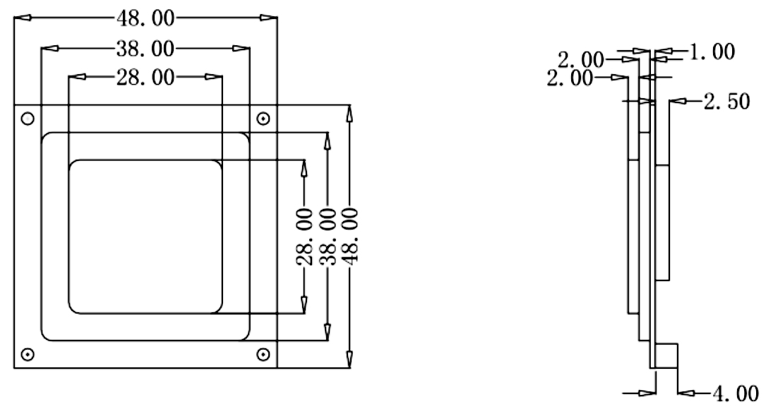
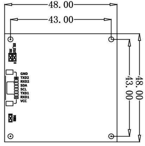
Table 1 PIN Function
|
NO.
|
Signal Name
|
Signal Description
|
|
1
|
VCC
|
Main power supply input, +3.3V to +5V
|
|
2
|
RXD1
|
First serial receives data pin, used for receiving serial date streams.
|
|
3
|
TXD1
|
First serial transmits data pin, used for receiving serial date streams.
|
|
4
|
SCL
|
Clock line in the l2C communication protocol, used for synchronizing data transfer.
|
|
5
|
SDA
|
Data line in the l2C communication protocol, used for bidirectional data transfer.
|
|
6
|
RXD2
|
Serials receive data pin, like RXD1, used for receiving another serial data stream.
|
|
7
|
TXD2
|
Serials transmit data pin, like TXD1, used for sending another serial data stream.
|
|
8
|
GND
|
Ground pin, used for connecting to the circuit's ground, providing the reference voltage needed for the circuit loop.
|
|
Note: Typically, VCC and GND are used for power supply, TX and RX are used for serial communication, while SCL and SDA are used for I²C communication. These interfaces allow the receiver to exchange power supply and data with external devices.
|
DALANG is a leading provider of high-performance GNSS and RTK solutions for unmanned aerial vehicles (UAVs) and other unmanned systems. We specialize in developing cutting-edge positioning modules that offer centimeter-level accuracy for various industrial applications. Our products are used extensively in industries such as agriculture, surveying, mapping, and infrastructure inspections. DALANG is committed to innovation and customer satisfaction, offering products that deliver high performance, reliability, and value. Our expertise in GNSS technology, along with our focus on quality, ensures that our products meet the highest standards of precision and reliability, helping clients achieve their operational goals efficiently.
Contact us today to inquire about the best RTK GPS module for your drone applications!
FAQ
How do I install the DALANG Drone RTK module?
The RTK GPS module is easy to install and integrates directly with your flight controller. Detailed installation instructions are provided for seamless setup.
What kind of accuracy can I expect from the RTK GPS module?
The RTK module for drone offers centimeter-level positioning accuracy, perfect for high-precision applications like surveying, mapping, and agricultural monitoring.
Can this module be used for long-duration flights?
Yes, the DALANG Drone RTK module is designed with low power consumption, allowing for extended drone operations without sacrificing accuracy.
Is the RTK GPS module compatible with all drone models?
The RTK GPS for sale module is compatible with a wide range of drones and flight controllers, ensuring easy integration with both commercial and custom-built UAV systems.
Is technical support available for this product?
Yes, DALANG provides comprehensive technical support, including installation assistance, troubleshooting, and optimization, ensuring that your RTK GPS module operates smoothly.