丨 Product IntroductionPowered by the domestic Beiyun M22 chip, the AK734 GNSS RTK receiver module integrates a dual-antenna GNSS receiver and 6-axis IMU inertial navigation system. It supports full-constellation multi-frequency satellite reception, delivering cm-level real-time positioning (horizontal ±1cm+1ppm) and 0.2° high-precision heading measurement in RTK mode. Featuring a tightly coupled integrated navigation algorithm, it switches to inertial navigation automatically when satellite signals are blocked, ensuring continuous positioning for UAVs, autonomous driving, and agricultural machinery applications.
Product Features:
1.Cm-level positioning:Supports multi-system RTK (BeiDou/GPS), delivering centimeter-level real-time dynamic accuracy.
2.Strong anti-interference:Stable signal in complex environments, suppressing multipath and electromagnetic interference.
3.Low power consumption:Optimized power efficiency, ideal for mobile devices and field operations.
4.Industrial-grade reliability:Wide temperature range, dust and vibration resistance, suitable for UAVs, autonomous driving and other harsh applications.
5.High compatibility:Fully compatible with Pixhawk, APM and other autopilot systems.
6.Low-noise performance:Industrial-grade low-noise RF circuit with excellent multipath suppression.
7.Dual IMU advantage:Dual IMU units enable redundancy backup + data fusion for stronger vibration resistance, uninterrupted navigation even if one unit fails, and high attitude accuracy with low drift.
Key Advantages
Stable Dual-IMU Positioning for Demanding Motion
Built around a compact dual-sensor layout, this module helps maintain attitude and heading consistency when the platform is vibrating, turning, or accelerating. The integrated structure reduces external wiring and keeps installation clean, which is useful for tight payload spaces on drones and mobile equipment. As a gnss gps rtk module, it is designed for precise positioning tasks that need repeatable output and dependable signal tracking. The internal sensor pairing also supports smoother data continuity during brief GNSS disruptions, helping the system keep usable navigation data in changing outdoor conditions.
Helical Antenna Design for Stronger Field Reliability
The antenna section uses a helical structure that is well suited to compact airborne and vehicle-mounted builds, offering practical reception performance without adding unnecessary bulk. This makes the unit easier to place on UAV frames and agricultural platforms where weight and layout matter. As a dual imu rtk module, it combines motion sensing with RTK positioning to support accurate control and mapping workflows. The integrated construction also helps reduce connection points, improving overall reliability for long operating sessions and repeated deployment in field environments.
丨 Product Structure
Standard version: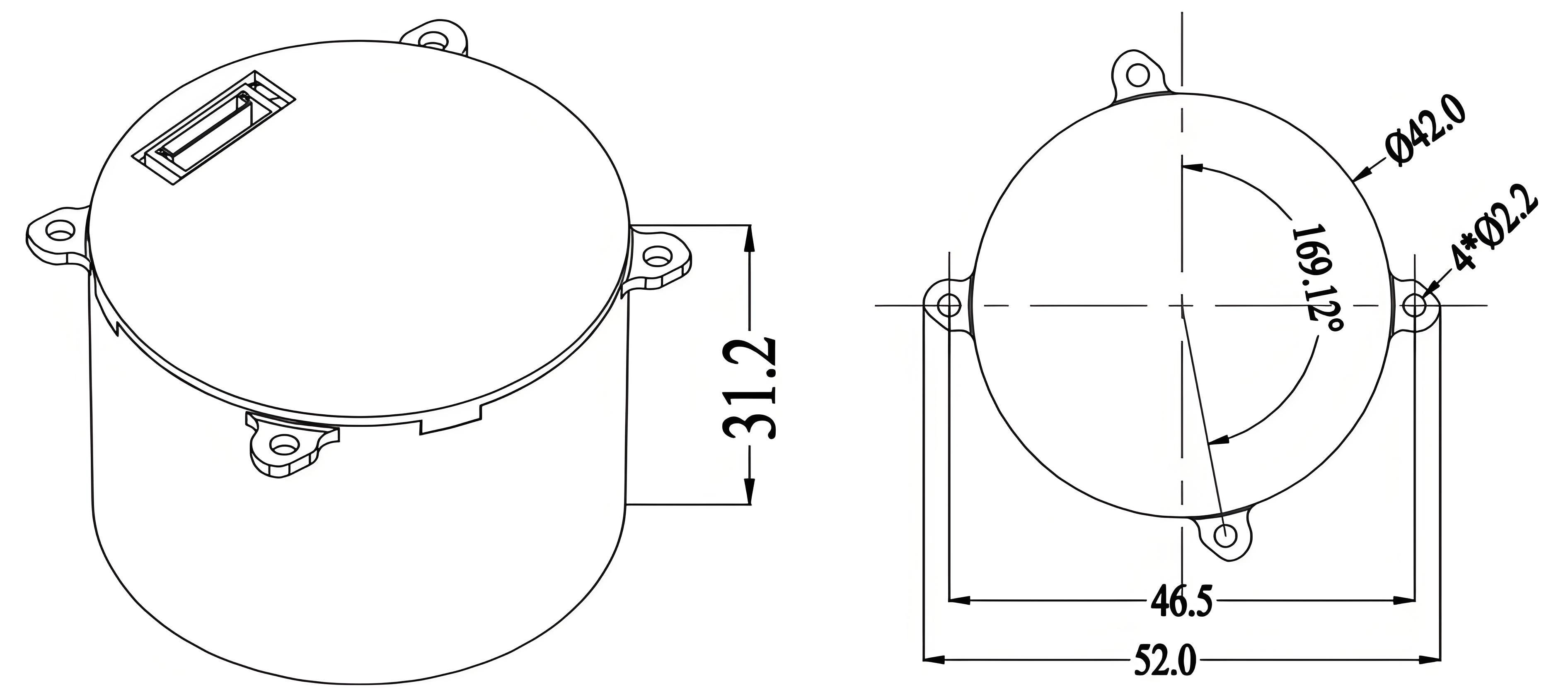
Upgraded version: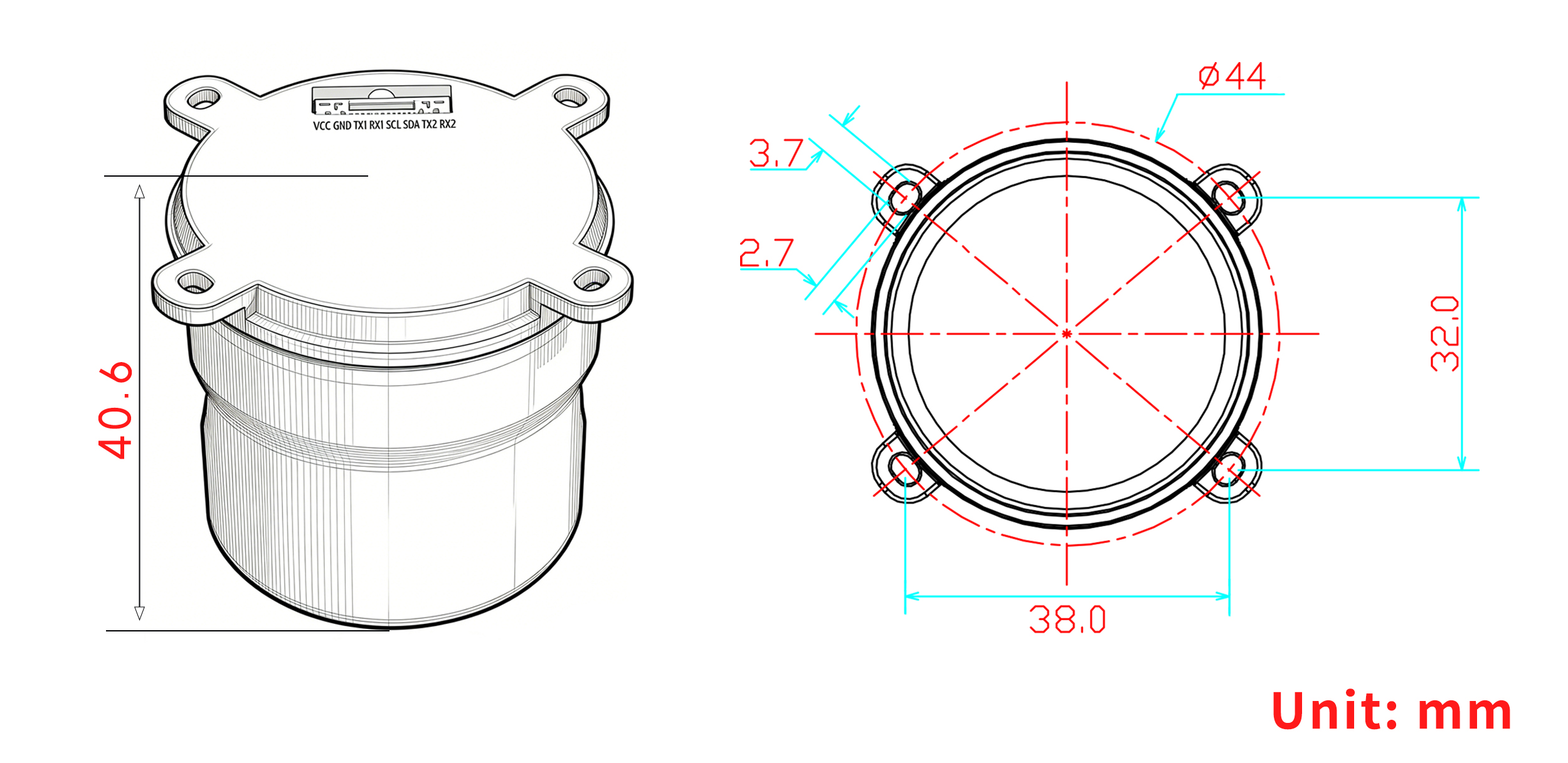
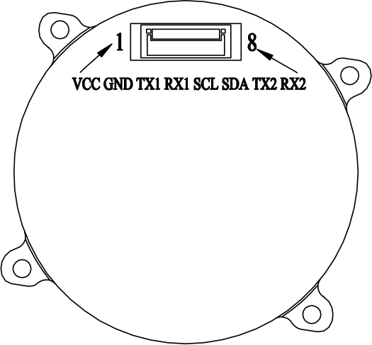
PIN Function
|
NO.
|
Pin name
|
Description
|
|
1
|
VCC
|
Main power input,+3.3V~5V
|
|
2
|
GND
|
Module grounding
|
|
3
|
TX1
|
UART1 output, 3.3V TTL
|
|
4
|
RX1
|
UART1 input, 3.3VTTL
|
|
5
|
SCL
|
I ² C serial clock
|
|
6
|
SDA
|
I ² C serial data
|
|
7
|
TX2
|
UART2 output, 3.3V TTL
|
|
8
|
RX2
|
UART2 input, 3.3VTTL
|
丨 Specification parameters
|
Chip
characteristics
|
Chip
|
Beiyun M22
|
|
Operating Frequency
|
BDS-2: B1I/B2I/B3I
BDS-3:B1C*/B2a/B2b(PPP)*/B3I
GPS: L1 C/A/L1C*/L2/L5
GLONASS: G1/G2
Galileo: E1/E5a/E5b/E6(HAS)*
QZSS: L1C/A/L1C/L2/L5、L6(CLAS)*
NavIC: L5
SBAS*:L1C/A
|
|
Receiving channel
|
1507 channel
|
|
Accuracy
|
Horizontal positioning accuracy (RMS)
|
Single point: 1.5m
|
|
RTK:1.0cm + 1ppm
|
|
Elevation positioning accuracy (RMS)
|
Single point: 2.5m
|
|
RTK:1.5cm + 1ppm
|
|
Timing accuracy (RMS)
|
≤ 20 ns
|
|
Speed accuracy (RMS)
|
0.03m/s
|
|
RTK calculation delay
|
50ms
|
|
Start Time
|
cold start
|
30s
|
|
hot start
|
5s
|
|
RTK initialization time
|
<5s (typical value)
|
|
Lost lock recapture time
|
<1s
|
|
IMU performance
(Gyroscope)
|
range
|
±300°/s
|
|
angle random walk
|
0.5°/√h
|
|
Zero bias instability
|
5°/h
|
|
Full temperature zero bias
|
0.3°/s
|
|
Scale error
|
4‰
|
|
Three-axis orthogonal coupling error
|
1.7(0.1°)‰)
|
|
IMU performance
(accelerometer)
|
range
|
± 16g
|
|
rate random walk
|
0.3m/s/√h
|
|
Zero bias instability
|
50μg
|
|
Full temperature zero bias
|
5μg
|
|
Scale error
|
2‰
|
|
Three-axis orthogonal coupling error
|
0.9(0.05°)‰
|
|
System functional safety*
|
ASIL B
|
|
Output data
|
Baud rate
|
115200bps (default) [Optional: 4800-921600]
|
|
output interface
|
TTL
|
|
Output Protocol
|
NMEA0183、RTCM 3.3
|
|
update frequency
|
GNSS positioning: 5-10 Hz
INS positioning: 100 Hz
IMU raw data: 100 Hz
|
|
Differential data
|
Differential data
|
RTCM 3.3/3.2/3.1/3.0
|
|
Carrier phase output
|
Support, output RAWX statement
|
|
FLASH
|
built-in
|
|
Electrical
specifications
|
working voltage
|
3~5.5V DC
|
|
power consumption
|
800mW
|
|
Physical
parameters
|
size
|
Standard version:φ42*31.2mm
Upgraded version:φ44*40.6mm
|
|
weight
|
Standard version: 13.2g
Upgraded version: 21g
|
|
joint
|
GH1.25mm 8pin
|
|
Environment
|
operation temperature
|
-35℃-80℃
|
|
storage temperature
|
-40℃-95℃
|
Packaging and Delivery:

Use Scenarios
UAV Mapping and Flight Control in Field OperationsThis module fits UAVs used for surveying, route planning, and terrain capture where accurate position data is needed throughout the flight. It is well suited to platforms that must hold a stable line of travel while collecting geo-referenced data over large areas. In uav precision agriculture, it can support crop scouting, field boundary work, and controlled spray paths. When paired with an rtkgps module, operators can build positioning workflows that better support centimeter-level location output for repeatable aerial operations.Crop Machinery Guidance and Farm Data CollectionOn tractors, sprayers, and other farm machines, the module can be used for line guidance, coverage logging, and position-based task management across uneven terrain. Its compact form is practical for equipment that already carries multiple sensors and communication devices. For precision farming setups, the uav precision agriculture keyword applies to broader operations where aerial and ground data are used together. The helical antenna module is a good fit for outdoor machinery that needs steady reception while moving through open fields and variable working conditions.
FAQ
Q1. What is this RTK module designed for?The unit is built for positioning tasks that require cm-level accuracy in UAV and agricultural machinery workflows. As a gnss gps rtk module, it is well suited to precision mapping, guidance, and field operations where stable location data is important.Q2. Does it include dual IMU and dual-antenna support?Yes, it integrates a dual IMU with a dual-antenna design to support attitude and positioning output in demanding motion environments. Our dual imu rtk module configuration is intended for systems that need reliable sensing alongside GNSS correction data.Q3. Can I use it on UAV platforms?Yes, it is intended for UAV applications where compact positioning hardware is needed. The helical antenna module design helps support GNSS reception in a practical form factor, and our team can help buyers verify fit with their platform layout before integration.Q4. Is it suitable for precision agriculture equipment?The module is suited to agricultural machinery that depends on accurate guidance and repeatable positioning. As an rtkgps module, it supports precision field use where consistent location performance is required for spraying, steering, or route planning.Q5. Do you provide integration support for system builders?Yes, we support system builders and procurement teams with product details for integration planning. For projects using a helical antenna module, we can help review installation needs, interface considerations, and application fit based on your target equipment and operating conditions.