丨 Product IntroductionProduct Introduction:
The AK735 IMU RTK receiver, powered by Beiyun M21 chip, delivers 1cm+1ppm high-precision positioning with multi-GNSS compatibility (GPS, BDS, GLONASS, Galileo). Equipped with dead reckoning technology, it maintains stable positioning even in signal-loss scenarios like urban canyons and tunnels. Boasting a compact 92g lightweight design, it’s ideal for UAV operations, ADAS, robot inspection and surveying tasks.
Features:
1. Multi-system compatibility: Supports Beidou/GPS/GLONASS/Galileo for better signal coverage & positioning reliability.
2. Centimeter-level precision: RTK tech enables real-time cm positioning for high-precision applications.
3. Strong anti-interference: Advanced algorithms maintain stability in complex environments.
4. Low-power design: Optimized power management for drones/portable devices.
5. Industrial-grade reliability: Wide temperature range, dust/quake resistance for harsh outdoor use.
Key Advantages
Dual-Mode Positioning for Reliable Outdoor and Partial-Obstacle TrackingThis gnss rtk navigation module combines multi-GNSS reception with RTK correction support to deliver centimeter-level positioning in demanding environments. The integrated design helps maintain stable output when satellite visibility changes, while the built-in IMU supports dead reckoning during short signal interruptions. It is well-suited for compact devices that need accurate navigation without extra bulky components. The module is a practical choice for developers who want a dependable gps rtk module with imu for precise motion tracking and consistent field performance.Compact INS Design for Demanding Integration NeedsBuilt as an ins gnss module, this unit pairs inertial sensing with satellite data to reduce drift and improve continuity in difficult terrain. Its architecture supports accurate output in areas where normal GNSS fixes are often unstable, including short tunnels and rocky corridors. The compact layout simplifies installation in mobile platforms, survey tools, and embedded systems where space is limited. For users comparing rugged positioning hardware, this rtk module for tunnels and canyons offers practical accuracy, strong signal recovery, and reliable compatibility for field deployment.丨 Product Structure
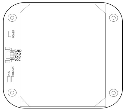
PIN Foot Function
|
NO.
|
Pin Definition
|
Describe
|
|
1
|
VCC
|
Main power input,+3.3V~5V
|
|
2
|
TX1
|
UART1 output, 3.3V TTL
|
|
3
|
RX1
|
UART1 input, 3.3VTTL
|
|
4
|
GND
|
Module grounding
|
|
Chip
characteristics
|
Chip
|
Beiyun M21
|
|
Operating Frequency
|
BDS-2: B1I/B2I/B3I
BDS-3:B1C*/B2a/B2b(PPP)*/B3I
GPS: L1 C/A/L1C*/L2/L5
GLONASS: G1/G2
Galileo: E1/E5a/E5b/E6(HAS)*
QZSS: L1C/A/L1C/L2/L5、L6(CLAS)*
NavIC: L5
SBAS*:L1C/A
|
|
Receiving channel
|
1507 channel
|
|
Accuracy
|
Horizontal positioning accuracy (RMS)
|
Single point: 1.5m
|
|
RTK:1.0cm + 1ppm
|
|
Elevation positioning accuracy (RMS)
|
Single point: 2.5m
|
|
RTK:1.5cm + 1ppm
|
|
Timing accuracy (RMS)
|
≤ 20 ns
|
|
Speed accuracy (RMS)
|
0.03m/s
|
|
RTK calculation delay
|
50ms
|
|
Start Time
|
cold start
|
30s
|
|
hot start
|
5s
|
|
RTK initialization time
|
<5s (typical value)
|
|
Lost lock recapture time
|
<1s
|
|
IMU performance
(Gyroscope)
|
range
|
±300°/s
|
|
angle random walk
|
0.5°/√h
|
|
Zero bias instability
|
5°/h
|
|
Full temperature zero bias
|
0.3°/s
|
|
Scale error
|
4‰
|
|
Three-axis orthogonal coupling error
|
1.7(0.1°)‰)
|
|
IMU performance
(accelerometer)
|
range
|
± 16g
|
|
rate random walk
|
0.3m/s/√h
|
|
Zero bias instability
|
50μg
|
|
Full temperature zero bias
|
5μg
|
|
Scale error
|
2‰
|
|
Three-axis orthogonal coupling error
|
0.9(0.05°)‰
|
|
System functional safety*
|
ASIL B
|
|
Output data
|
Baud rate
|
115200bps (default) [Optional: 4800-921600]
|
|
output interface
|
TTL
|
|
Output Protocol
|
NMEA0183、RTCM 3.3
|
|
update frequency
|
GNSS positioning: 1-10 Hz(Default 1HZ)
INS positioning: 100 Hz
IMU raw data: 100 Hz
|
|
Differential
data
|
Differential data
|
RTCM 3.3/3.2/3.1/3.0
|
|
Carrier phase output
|
Support, output RAWX statement
|
|
FLASH
|
built-in
|
|
Electrical
specifications
|
working voltage
|
3~5.5V DC
|
|
power consumption
|
800mW
|
|
Physical
parameters
|
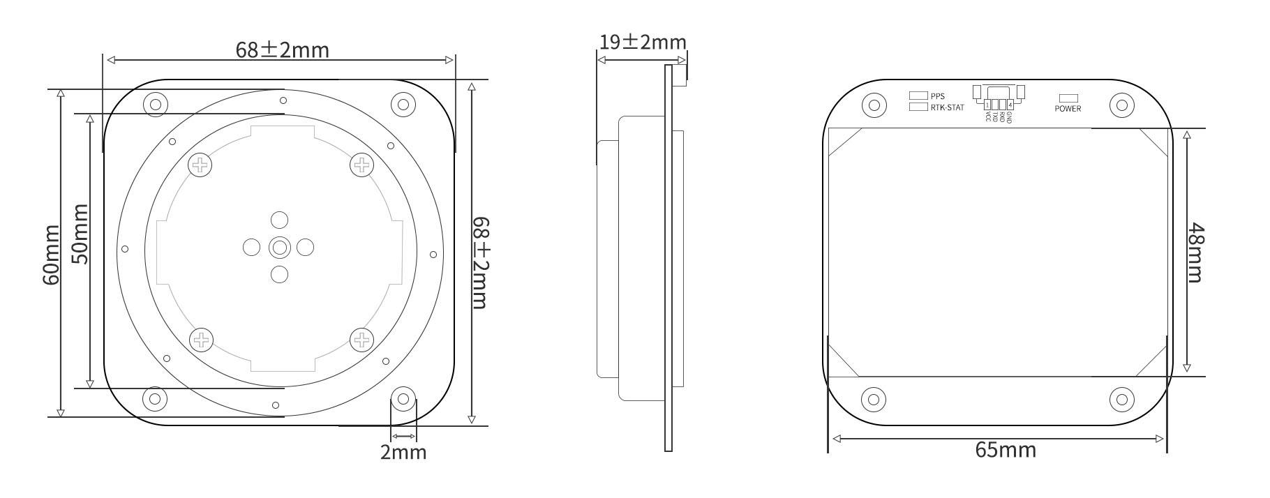
size
|
68*68*19mm
|
|
weight
|
92g
|
|
joint
|
GH1.25mm 4pin
|
|
Environment
|
operation temperature
|
-35℃-80℃
|
|
storage temperature
|
-40℃-95℃
|
Packaging and Delivery:

Use Scenarios
UAV and Mobile Mapping in Signal-Challenged AreasSurvey teams can mount this module on drones to keep position estimates steady during flights over cliffs, tree lines, and urban gaps. The correction-ready output helps operators collect more accurate geo-tagged data for mapping and inspection tasks. When satellite signals drop for a moment, the inertial assist helps maintain track continuity, which is valuable for flight paths that pass through uneven terrain. Buyers looking to buy gnss rtk module for aerial measurement can use it as a dependable gnss rtk navigation module for fieldwork that needs precise location data.Vehicle Navigation and Underground Passage TrackingThis unit fits commercial vehicles, inspection carts, and autonomous platforms that must keep positioning stable in places where GNSS alone is weak. It is useful for road testing, mine support routes, and tunnel entry zones where short outages are common. The IMU-backed output helps the system estimate movement until satellite lock returns, reducing lost position data during transitions. Integration teams can also deploy it as a gps rtk module with imu for fleet systems, while the ins gnss module structure supports reliable use in canyons, underpasses, and other difficult routes.
FAQ
Q1. What makes this module suitable for difficult GNSS environments?Yes, our gnss rtk navigation module is designed to maintain stable positioning where satellite visibility is reduced, including tunnels and canyons. It combines multi-GNSS support with inertial dead reckoning so users can continue navigation when GNSS signals are interrupted.Q2. How does the IMU help when GNSS signals are weak?The gps rtk module with imu uses inertial data to help bridge short signal losses and support position continuity. For operators working in obstructed areas, this adds practical stability when direct satellite fixes are not always available.Q3. Is this module appropriate for surveying and mapping work?The unit delivers 1cm+1ppm precision under suitable RTK conditions, which makes it well-suited for surveying tasks that require high positioning accuracy. We recommend integrating it into systems where precise location data is a core requirement.Q4. Can I use this for UAV or ADAS integration?Our ins gnss module is intended for applications that need reliable navigation support, including UAV and ADAS-related systems. We provide a platform focused on stable positioning, and integration should follow your system architecture and validation process.Q5. Is this a good choice if I need positioning in tunnels and canyons?Yes, it is built for use in areas where GNSS is challenged, including tunnel and canyon environments. If you plan to buy gnss rtk module for those conditions, our team suggests confirming your application’s power, interface, and integration needs before deployment.