Product Advantages
Structural and System Design Benefits for Integration
The module’s compact design and standardized form factor facilitate seamless integration into existing platforms, including UAVs and precision agricultural devices. The combination of a GNSS GPS RTK module with a built-in IMU reduces system complexity by minimizing extra hardware requirements. Its multi-constellation GNSS support and advanced anti-interference algorithms ensure consistent signal acquisition across varied geographic regions and conditions. Power-efficient operation extends functional endurance for battery-powered applications, while the GH1.25 mm 8-pin connector standardizes electrical interfaces. These design choices highlight a modular architecture optimized for professional deployment.
Performance and User-Centric Operation Advantages
Users experience rapid RTK initialization and centimeter-level positioning accuracy with minimal setup complexity, enhancing operational productivity. The integrated inertial navigation system maintains positioning integrity during signal dropouts, crucial for precise flight control and sensor alignment in UAV and agricultural contexts. Low power consumption and device durability under extreme temperatures increase reliability in field conditions. The module supports multiple output protocols simplifying integration with diverse software and hardware systems. Together, these features translate to improved user confidence, reduced downtime, and higher data quality in critical positioning applications.
丨 Product IntroductionAK724 High-Precision RTK Receiver Module is equipped with the Beiyun M21 GNSS baseband chip and IST8310 geomagnetic sensor, supports multi-system signals including BDS and GPS, features a built-in single inertial navigation function for auxiliary positioning and delivers centimeter-level real-time positioning accuracy; integrated with high-performance anti-interference algorithms and low-power design, it is suitable for high-precision positioning scenarios such as UAVs and precision agriculture, boasts fast convergence, stability and reliability, and serves as a cost-effective RTK solution that significantly improves positioning efficiency and accuracy in complex environments.
Product Features:
1.Multi-system compatibility: Works with Beidou, GPS, GLONASS, Galileo, boosting signal coverage and positioning reliability.
2.Centimeter-level precision: RTK tech delivers real-time centimeter positioning for high-precision use cases.
3.Strong anti-interference: Advanced algorithms maintain stability in complex environments.
4.Low-power design: Optimized power management, ideal for drones/portable devices.
5.Rapid convergence: High-sensitivity tech cuts RTK initialization time and boosts efficiency.
6.Inertial navigation: Built-in single IMU, GNSS-coupled, enables short-term blind positioning (no satellite) for medium/light equipment.
丨 Product Structure
Standard version: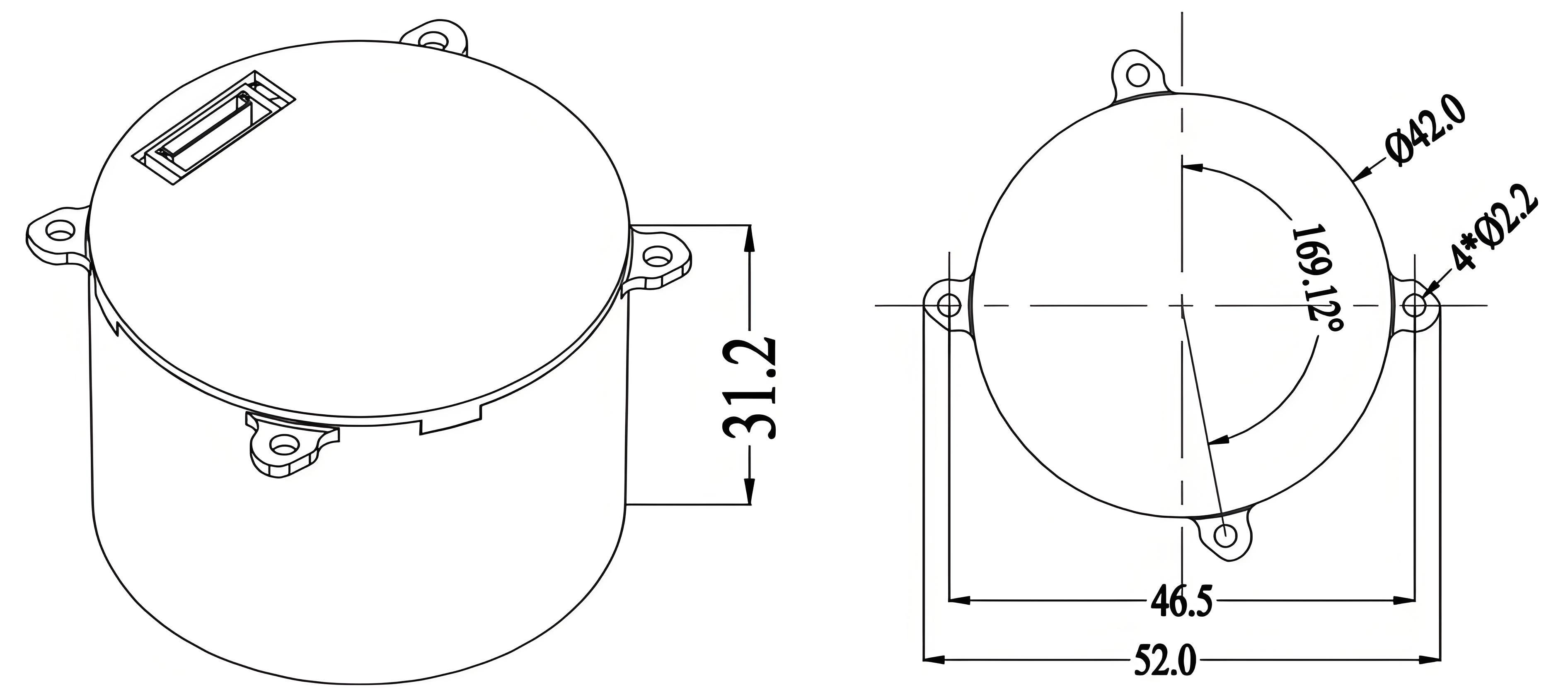
Upgraded version: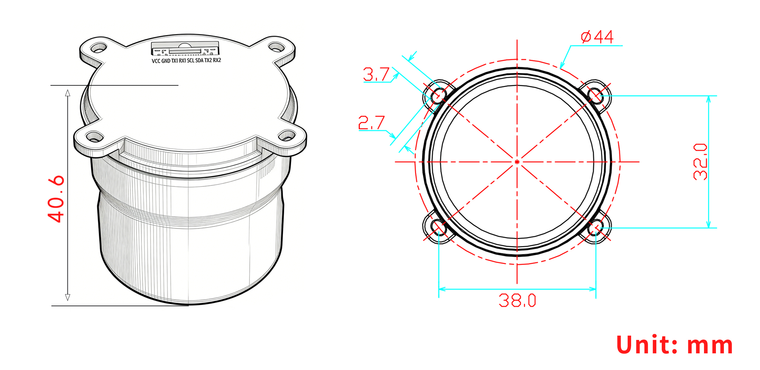
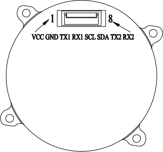
PIN Function
|
NO.
|
Pin name
|
Description
|
|
1
|
VCC
|
Main power input,+3.3V~5V
|
|
2
|
GND
|
Module grounding
|
|
3
|
TX1
|
UART1 output, 3.3V TTL
|
|
4
|
RX1
|
UART1 input, 3.3VTTL
|
|
5
|
SCL
|
I ² C serial clock
|
|
6
|
SDA
|
I ² C serial data
|
|
7
|
TX2
|
UART2 output, 3.3V TTL
|
|
8
|
RX2
|
UART2 input, 3.3VTTL
|
丨 Specification parameters
|
Chip
characteristics
|
Chip
|
Beiyun M21
|
|
Operating Frequency
|
BDS-2: B1I/B2I/B3I
BDS-3:B1C*/B2a/B2b(PPP)*/B3I
GPS: L1 C/A/L1C*/L2/L5
GLONASS: G1/G2
Galileo: E1/E5a/E5b/E6(HAS)*
QZSS: L1C/A/L1C/L2/L5、L6(CLAS)*
NavIC: L5
SBAS*:L1C/A
|
|
Receiving channel
|
1507 channel
|
|
Accuracy
|
Horizontal positioning accuracy (RMS)
|
Single point: 1.5m
|
|
RTK:1.0cm + 1ppm
|
|
Elevation positioning accuracy (RMS)
|
Single point: 2.5m
|
|
RTK:1.5cm + 1ppm
|
|
Timing accuracy (RMS)
|
≤ 20 ns
|
|
Speed accuracy (RMS)
|
0.03m/s
|
|
RTK calculation delay
|
50ms
|
|
Start Time
|
cold start
|
30s
|
|
hot start
|
5s
|
|
RTK initialization time
|
<5s (typical value)
|
|
Lost lock recapture time
|
<1s
|
|
IMU performance
(Gyroscope)
|
range
|
±300°/s
|
|
angle random walk
|
0.5°/√h
|
|
Zero bias instability
|
5°/h
|
|
Full temperature zero bias
|
0.3°/s
|
|
Scale error
|
4‰
|
|
Three-axis orthogonal coupling error
|
1.7(0.1°)‰)
|
|
IMU performance
(accelerometer)
|
range
|
± 16g
|
|
rate random walk
|
0.3m/s/√h
|
|
Zero bias instability
|
50μg
|
|
Full temperature zero bias
|
5μg
|
|
Scale error
|
2‰
|
|
Three-axis orthogonal coupling error
|
0.9(0.05°)‰
|
|
System functional safety*
|
ASIL B
|
|
Output data
|
Baud rate
|
115200bps (default) [Optional: 4800-921600]
|
|
output interface
|
TTL
|
|
Output Protocol
|
NMEA0183、RTCM 3.3
|
|
update frequency
|
GNSS positioning: 5-10 Hz
INS positioning: 100 Hz
IMU raw data: 100 Hz
|
|
Differential
data
|
Differential data
|
RTCM 3.3/3.2/3.1/3.0
|
|
Carrier phase output
|
Support, output RAWX statement
|
|
FLASH
|
built-in
|
|
Electrical
specifications
|
working voltage
|
3~5.5V DC
|
|
power consumption
|
800mW
|
|
Physical
parameters
|
size
|
Standard version:φ42*31.2mm
Upgraded version:φ44*40.6mm
|
|
weight
|
Standard version: 13.2g
Upgraded version: 21g
|
|
joint
|
GH1.25mm 8pin
|
|
Environment
|
operation temperature
|
-35℃-80℃
|
|
storage temperature
|
-40℃-95℃
|
|
Compass
|
Compass
|
IST8310
|
Packaging and Delivery:

Use Scenarios
Enhanced UAV Navigation in Complex Flight Environments
In unmanned aerial vehicle operations, particularly in environments with intermittent satellite visibility like urban areas or forested zones, the RTK module for UAV applications ensures uninterrupted centimeter-level accuracy. By integrating GNSS and inertial navigation, flight controllers receive continuous positioning updates, enabling precise route adherence and stable hover control. The device’s rapid RTK initialization accelerates mission readiness, while its anti-interference capabilities maintain signal integrity amidst electromagnetic disturbances. This module complies with demanding UAV control systems, supporting advanced applications such as inspection, mapping, and autonomous delivery services.
Precision Agriculture Sensor Networks for Optimized Crop Management
Agricultural technology leverages this GNSS module with IMU to provide continuous, high-accuracy positioning data necessary for precision farming. In fields where GNSS signals might be partially obstructed by terrain or foliage, the inertial navigation function maintains sensor location awareness, minimizing downtime and data inaccuracies. Its power-efficient design suits sensor nodes and autonomous farming vehicles that demand extended battery life. Integration with farm management platforms enables precise planting, fertilization, and harvesting workflows. This RTK module for precision agriculture drives yield improvements by maximizing the reliability and precision of location-based decision-making tools.
FAQ
What makes this GNSS GPS RTK module suitable for drone applications?
Our GNSS GPS RTK module combines multi-system satellite signals with a built-in IMU for inertial navigation, enabling centimeter-level accuracy and short-term blind positioning. Its low power consumption and fast RTK initialization make it ideal for reliable UAV flight control and navigation.
Can I integrate the Beiyun M21 IST8310 module with other devices through its IO interfaces?
Yes, the module features multiple IO interfaces including UART and I2C pins like TX1, RX1, SCL, and SDA. These connections allow seamless integration with external controllers and sensors, supporting flexible deployment for various precision applications.
How do you ensure the module maintains accuracy during satellite signal blockages?
We equip our GNSS module with IMU inertial navigation technology that supplements satellite data. The built-in IMU and advanced anti-interference algorithms enable continuous positioning even when satellite signals are temporarily blocked, ensuring consistent accuracy in challenging conditions.
Is it possible to customize the output data protocols or baud rates for this RTK module?
Yes, we offer configurable output protocols such as NMEA0183 and RTCM 3.x, with default baud rates at 115200 bps. Optional baud rates range from 4800 to 921600 bps, allowing you to tailor data communication according to your specific needs for precise positioning systems.