丨 Product Introduction
1. Flexible configuration: can be set as a base or roaming station.
2. Multifunctional: Supports differential positioning and vector attitude measurement.
3. Low noise RF circuit: Suppresses interference to obtain clear signals and accurate positioning.
4. Compatibility: Fully compatible with Pixhawk, APM and other auto drive system.
丨 Specification parameters
|
Chip
characteristics
|
chip
|
UM982
|
|
Working mode
|
BDS: B1I、B2I、B3I
GPS: L1C/A、L2P (Y)、L2C、L5
GLONASS: L1、L2
Galileo: E1、E5a、E5b
QZSS: L1、L2、L5
|
|
Receiving channel
|
1408 channel
|
|
Accuracy
|
Single point positioning (RMS)
|
Plane: 1.5m
|
|
Elevation: 2.5m
|
|
DGPS(RMS)
|
Plane: 0.4m
|
|
Elevation: 0.8m
|
|
RTK(RMS)
|
Flat: 0.8cm+1ppm
|
|
Elevation: 1.5cm+1ppm
|
|
Directional accuracy (RMS)
|
0.2 degrees/1m baseline
|
|
Time accuracy (RMS)
|
20 ns
|
|
Speed accuracy (RMS)
|
0.2 m/s
|
|
Observation accuracy (RMS)
|
BDS
|
GPS
|
GLONASS
|
Galileo
|
|
B1I/B1C/L1 C/A/E1/G1 pseudorange
|
10cm
|
10cm
|
10cm
|
10cm
|
|
B1I/B1C/ L1 C/A/E1/G1 Carrier Phase
|
1mm
|
1mm
|
1mm
|
1mm
|
|
B3I/L2P(Y)/L2C/G2 pseudorange
|
10cm
|
10cm
|
10cm
|
10cm
|
|
B3I/L2P(Y)/L2C/G2 Carrier Phase
|
1mm
|
1mm
|
1mm
|
1mm
|
|
B2I/ L5/E5a/E5b pseudorange
|
10cm
|
10cm
|
10cm
|
10cm
|
|
B2I/ L5/E5a/E5b Carrier Phase
|
1mm
|
1mm
|
1mm
|
1mm
|
|
Time To First
Fix TTFF
|
cold boot
|
<20s
|
|
Initialization time
|
<5s ( Typical values)
|
|
Initialize reliability
|
>99.9%
|
|
Output data
|
Baud rate
|
115200bps (default) [Optional: 4800-921600]
|
|
Output interface
|
TTL/USB
|
|
Output Protocol
|
NMEA0183、RTCM 3.3
|
|
Data update rate
|
1Hz-20Hz (default 1Hz)
|
|
Differential data
|
RTCM 3.3/3.2/3.1/3.0
|
|
Carrier phase output
|
Support, output RAWX statement
|
|
FLASH
|
built-in
|
|
Electrical
specifications
|
working voltage
|
3.3~5V DC
|
|
power waste
|
<800mW
|
|
Physical
parameters
|
size
|
50*30mm*3.5mm
|
|
weight
|
8.2g
|
|
Connector
|
GH1.25 4pin*2
|
|
Antenna connector
|
MMCX Elbow (customizable)*2
|
|
Environment
|
working temperature
|
-35℃-80℃
|
|
Storage temperature
|
-40℃-85℃
|
丨 product mix
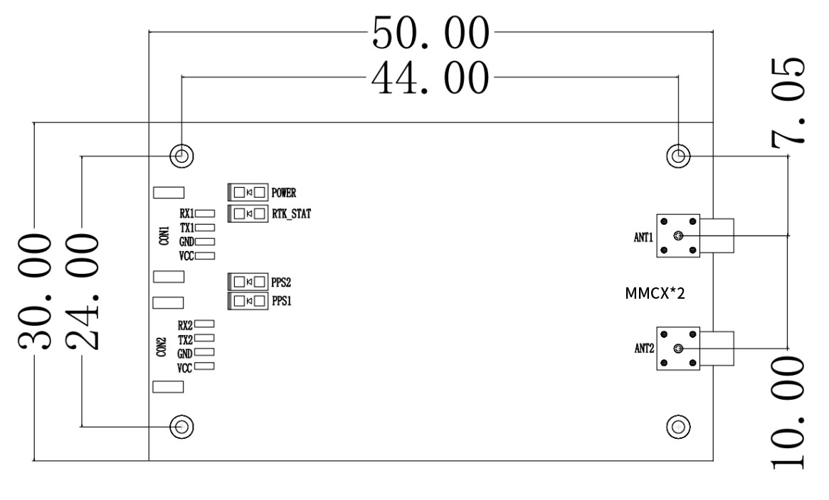
Table 1 PIN Functionality
|
Pin Number
|
Signal Name
|
Signal Description
|
|
1
|
VCC
|
COM1 main power input: 3.0-5.5V
|
|
2
|
GND
|
COM1 module grounding
|
|
3
|
TXD 1
|
COM1 outputs NMEA0183 format when set as a rover and RTCM2.x/3.x format when set as a base station.
|
|
4
|
RXD 1
|
COM1 main serial port receives data and serves as the command input port.
|
|
5
|
VCC
|
COM1 main power input: 3.0-5.5V
|
|
6
|
GND
|
COM2 main power input: 3.0-5.5V
|
|
7
|
TXD2
|
COM2 output interface
|
|
8
|
RXD2
|
COM2 accepts RTCM2.x/3.x differential data input when configured as a rover.
|
|
Indicator light
|
1
|
RTK-STAT
|
RTK indicator: high when fixed, low for other states or no positioning.
|
|
2
|
POWER
|
Indicates power supply status.
|
|
3
|
PPS
|
Pulse per second (PPS) output emits pulses and the indicator flashes after positioning.
|
Table 2 Interface Characteristics
|
NO.
|
Name
|
Symbol
|
Minimum Value
|
Typical Value
|
Maximum Value
|
Unit
|
|
1
|
Main Power
|
VCC
|
2.7
|
3.3
|
5.0
|
V
|
|
2
|
Backup Power
|
VBAT
|
1.4
|
3.3
|
3.6
|
V
|
|
3
|
RF Port Feed
|
VRF
|
3.0
|
3.1
|
3.3
|
V
|
|
4
|
High-Level Input
|
VIH
|
2.0
|
|
|
V
|
|
5
|
Low-Level Input
|
VIL
|
|
|
0.7
|
V
|
|
6
|
High-Level Output
|
VOH
|
3.2
|
|
|
V
|
|
7
|
Low-Level Output
|
VOL
|
|
|
0.1
|
V
|
|
8
|
Main Serial Port Baud Rate
|
Baud
|
|
115200
|
|
bps
|
|
9
|
Differential Baud Rate
|
Baud
|
|
115200
|
|
bps
|

A Centimeter-Level GNSS Positioning Engine for UAVs and Robotics
The DALANG AK370W is an ultra-low-cost, low-power dual-antenna RTK positioning module designed based on the advanced UM982 platform. It supports all-constellation satellite signals and provides real-time centimeter-level positioning and heading information for UAVs, unmanned vehicles, agricultural machinery, and precision surveying. This powerful RTK solution is the ideal choice for achieving precise positioning and attitude awareness.
High-Frequency RTK Engine for Precise Heading & Positioning
Leveraging its high-performance multi-band RTK engine, the AK370W achieves a fixed solution rapidly even in complex environments, delivering stable and reliable GNSS data. Whether your device is a high-speed drone or a precision agricultural robot, this module ensures the accurate position and heading tracking required for your workflow.
Designed for Open Source Systems and Integrators
The AK370W is fully compatible with mainstream open-source flight controllers like Pixhawk, APM, and PX4, supporting flexible configuration and deployment. It is the perfect RTK module for developers and manufacturers seeking to integrate high-precision positioning and heading functions into their products.
Excels in Demanding Applications
Thanks to its low-noise RF circuit design and powerful anti-interference capability, the AK370W performs exceptionally well in GNSS-challenged environments such as urban canyons and wooded areas. It is a proven and reliable solution for users who need stable output in real-world conditions.
Product Advantages
Multi-System Support & Dual-Antenna Heading for Ultimate Accuracy
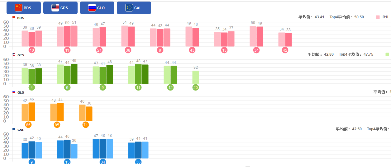
The module supports six major satellite systems - GPS, BDS, GLONASS, Galileo, QZSS, and SBAS - and features dual-antenna input. This not only achieves real-time centimeter-level positioning but also provides heading accuracy up to 0.2 degrees per meter baseline, an essential function for professional navigation and control.
Quad-Mode RTK & High Update Rate for Rapid Response
Utilizing advanced Quad-Mode RTK technology, it ensures fast and accurate positioning across various environments. Simultaneously, a high data output rate of up to 20Hz allows it to perfectly meet the stringent real-time requirements of high-speed mobile platforms.
Optimized for Industrial Integration & OEM Use
The module provides interfaces including TTL and USB, defaults to 115200 baud rate, and features built-in Flash for configuration storage. Its compact size (50x30mm) and low power consumption (<800mW) make it easy to integrate into various UAVs, robots, and AGV systems.
Stable, Reliable, and Easy to Integrate
The AK370W operates over a wide voltage range (3.3V-5V) and industrial temperature range (-35°C ~ +80°C), ensuring long-term stability in harsh environments. It is a plug-and-play high-precision positioning and heading solution.
Looking for a high-precision positioning and heading solution for your UAV or robotic system? Inquire about the DALANG AK370W RTK module today and upgrade your project with real-time centimeter-level performance.
About Us
DALANG is a dedicated manufacturer of high-performance GNSS modules and RTK positioning solutions, serving industries such as UAV navigation, precision agriculture, and geospatial mapping. With a clear focus on accuracy, reliability, and integration flexibility, we support both standard and custom applications across global markets. Our product lines are engineered to meet the evolving demands of real-time positioning with support for multiple GNSS constellations, including GPS, GLONASS, BDS, and Galileo.
Our production facility spans 2,500㎡ and includes advanced SMT lines, in-house R&D labs, and full functional testing for every unit shipped. With a team of 30+ GNSS engineers, we design and manufacture over 200,000 GNSS receivers and modules annually. Certified to ISO9001:2015, and compliant with CE and RoHS standards, we follow a strict quality assurance process from prototyping through mass production. We also provide firmware updates, system integration support, and full lifecycle product documentation.
Trusted by partners in over 30 countries, DALANG delivers fast, scalable manufacturing with personalized technical support. Our streamlined collaboration model—covering inquiry, consultation, prototyping, and delivery—ensures efficiency from first contact to deployment. Whether you're sourcing off-the-shelf GNSS hardware or launching a customized solution, DALANG is your dependable partner for accurate, cost-effective positioning systems.
FAQ
1. Who are we?
We are DALANG, a specialized manufacturer of GNSS modules and RTK positioning systems based in China, with a focus on high-precision solutions for UAVs, surveying, and smart agriculture.
2. How can we guarantee quality?
All products undergo strict multi-stage quality control, including SMT production, functional testing, and 100% final inspection. We are ISO9001:2015 certified and follow international compliance standards such as CE and RoHS.
3. What can you buy from us?
You can purchase GNSS receivers, RTK modules, base stations, antennas, flight control positioning systems, and other GNSS-related components and accessories.
4. Why should you buy from us not from other suppliers?
We combine strong in-house R&D, flexible OEM/ODM support, industrial-grade quality assurance, and fast global delivery. Our expertise in GNSS RTK ensures stable, accurate, and scalable solutions tailored to your specific use case.
5. What services can we provide?
We offer OEM/ODM customization, technical consulting, firmware support, prototyping, and global after-sales service. Our team works closely with international clients to ensure efficient communication and long-term support.