丨 Product Introduction
1.Support full constellation multi frequency chip level RTK positioning and dual antenna heading solutions.
2.Supports BDS, GPS, GLONASS, Galileo, QZSS, and SBAS.
3.Can be used as a base station or mobile station, as well as for heading.
4.Adaptive recognition of differential input RTCM format.
5.Adopt on-board standard 9-36V wide voltage input.
6.Adopt industrial grade 1W wireless radio module.
丨 Specification parameters
|
Specification parameters
|
|
GNSS module
|
1
|
Working mode
|
BDS: B1I、B2I、B3I
GPS: L1C/A、L2P (Y)、L2C、L5
GLONASS: L1、L2
Galileo: E1、E5a、E5b
QZSS: L1、L2、L5
|
|
2
|
Receiving channel
|
1408 channel
|
|
3
|
Single point positioning (RMS)
|
Plane: 1.5m
|
|
Elevation: 2.5m
|
|
4
|
DGPS(RMS)
|
Plane: 0.4m+1ppm
|
|
Elevation: 0.8m+1ppm
|
|
5
|
RTK(RMS)
|
Flat: 0.008m+1ppm
|
|
Elevation: 0.015m+1ppm
|
|
6
|
Directional accuracy (RMS)
|
0.2 degrees/1m baseline
|
|
7
|
Time accuracy (RMS)
|
20ns
|
|
8
|
Speed accuracy (RMS)
|
0.03m/s
|
|
9
|
Observation accuracy (RMS)
|
BDS
|
GPS
|
GLONASS
|
Galileo
|
|
10
|
B1I/B1C/L1 C/A/E1/G1 pseudorange
|
10cm
|
10cm
|
10cm
|
10cm
|
|
11
|
B1I/B1C/L1 C/A/E1/G1 carrier phase
|
1mm
|
1mm
|
1mm
|
1mm
|
|
12
|
B3I/L2P (Y)/L2C/G2 pseudorange
|
10cm
|
10cm
|
10cm
|
10cm
|
|
13
|
B3I/L2P (Y)/L2C/G2 carrier phase
|
1mm
|
1mm
|
1mm
|
1mm
|
|
14
|
B2I/L5/E5a/E5b pseudorange
|
10cm
|
10cm
|
10cm
|
10cm
|
|
15
|
B2I/L5/E5a/E5b carrier phase
|
1mm
|
1mm
|
1mm
|
1mm
|
|
16
|
cold boot
|
<30s
|
|
17
|
Initialization time
|
<5s (typical value)
|
|
Radio module
|
1
|
frequency range
|
410-470MHz
|
|
2
|
Channel spacing
|
25KHz
|
|
3
|
Working mode
|
half-duplex
|
|
4
|
Frequency stability
|
<±1.5ppm
|
|
5
|
modulation mode
|
GMSK \ 4FSK
|
|
6
|
Airborne baud rate
|
9600bps 19200bps
|
|
7
|
Protocol type
|
TRIMATLK/South/TRANSEOT/TRIMMARK3
|
|
8
|
Serial port baud rate
|
4800/9600/19200/38400/115200bps
|
|
9
|
Power (typical value)
|
High power transmission: 4.0W@3.3V DC
|
|
Low power (0.5W): 27.0 ± 1.2dBm@DC 3.3V
|
|
Machine standby: 0.3W@3.3V DC
|
|
10
|
Transmitting RF output power
(410-470MHz)
|
High power (1.0W): 30.2 ± 1.0dBm@DC 3.3V
|
|
Low power (0.5W): 27.0 ± 1.2dBm@DC 3.3V
|
|
11
|
Stability of RF power transmission
|
≤±1dB
|
|
12
|
Receiver Sensitivity
|
> -115dBm@BER 10-3, 9600bps
|
|
13
|
Receive common channel suppression
|
>-12dB
|
|
Interface
|
1
|
Wireless interface
|
SMA ports
|
|
2
|
GNSS interface
|
SMA ports
|
|
3
|
Data/power interface
|
8-core LEMO ports
|
|
Data format
|
1
|
Differential data
|
RTCM3.X
|
|
2
|
output format
|
NMEA-0183, RTCM3.X
|
|
3
|
Data update rate
|
1Hz-20Hz(default 1Hz)
|
|
power supply
|
1
|
Voltage
|
DC +9V~36V
|
|
2
|
power waste
|
<3W
|
|
3
|
indicator light
|
1power,1PPS,1RTK
|
|
Physical
parameters
|
1
|
size
|
100mm*61.8mm*18.75mm
|
|
2
|
weight
|
180g
|
|
3
|
Shell material
|
aluminium
|
|
Environmental
Specifications
|
1
|
working temperature
|
-30℃ ~ +70℃
|
|
2
|
Storage temperature
|
-55℃ ~+85℃
|
|
3
|
humidity
|
95%condensation
|
|
4
|
Protection grade
|
IP66
|
|
5
|
Seismic resistance
|
Resist the impact of a 1-meter free fall
|
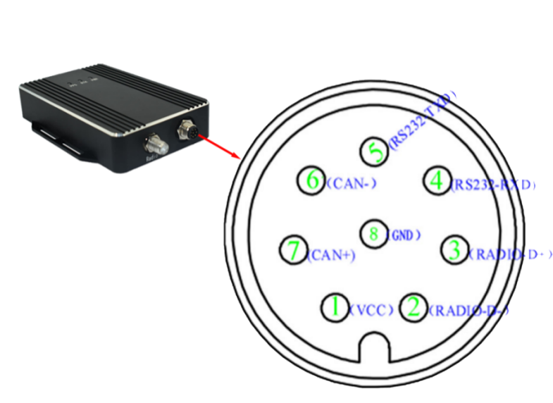
Table 1 M8 Interface Definition
|
M8-8P Male Interface Description
|
|
No.
|
Interface Name
|
Function Description
|
|
1
|
VCC
|
Input voltage 9-36V (typical value 12V), current 3A
|
|
2
|
RADIO-D-
|
Radio serial port USB D-
|
|
3
|
RADIO-D+
|
Radio serial port USB D+
|
|
4
|
RS232-RXD
|
GNSS module RS232 RXD
|
|
5
|
RS232-TXD
|
GNSS module RS232 TXD
|
|
6
|
CAN-
|
NC
|
|
7
|
CAN+
|
NC
|
|
8
|
GND
|
Mainboard GND
|
|
LED Indicator Interaction
|
|
1
|
PWR
|
The power indicator light is always red during normal operation, flashing red and green alternately during transmission, and flashing red and blue alternately during reception
|
|
2
|
RTK
|
Differential positioning indicator, solid blue in FIX state
|
|
3
|
PPS
|
Positioning indicator, green light flashes, provides an output pulse per second (1PPS) signal with adjustable pulse width and polarity
|
|
Antenna Interface Definition
|
|
1
|
GNSS 1 Antenna
|
SMA female, primarily receives GNSS antenna signals, antenna power supply 5V
|
|
2
|
GNSS 2 Antenna
|
SMA female, primarily receives GNSS antenna signals, antenna power supply 5V
|
|
3
|
Radio Antenna
|
SMA male, primarily receives/transmits 410-470MHz antenna signals
|
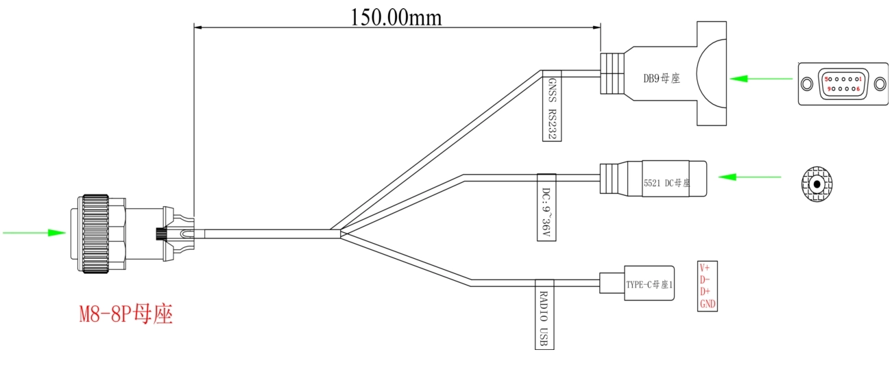
Structural diagram of connecting cables:
Complete scheme display:
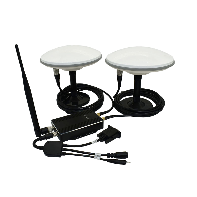
Table 2 Complete Component Description
|
No.
|
Product Name
|
Function Description
|
|
1
|
Connection Cable
|
8-pin aviation connector to Type-C; DC-DC power;DB9 female connector
|
|
2
|
Receiver
|
Built-in GNSS module and Radio module
|
|
3
|
Radio Antenna
|
433±20MHz antenna
|
|
4
|
5-meter Coaxial Cable
|
TNC to SMA, 50-3 cable
|
|
5
|
5-meter Coaxial Cable
|
TNC to SMA, 50-3 cable
|
|
6
|
GNSS1Antenna
|
All-system, all-frequency antenna
|
|
7
|
GNSS2Antenna
|
All-system, all-frequency antenna
|
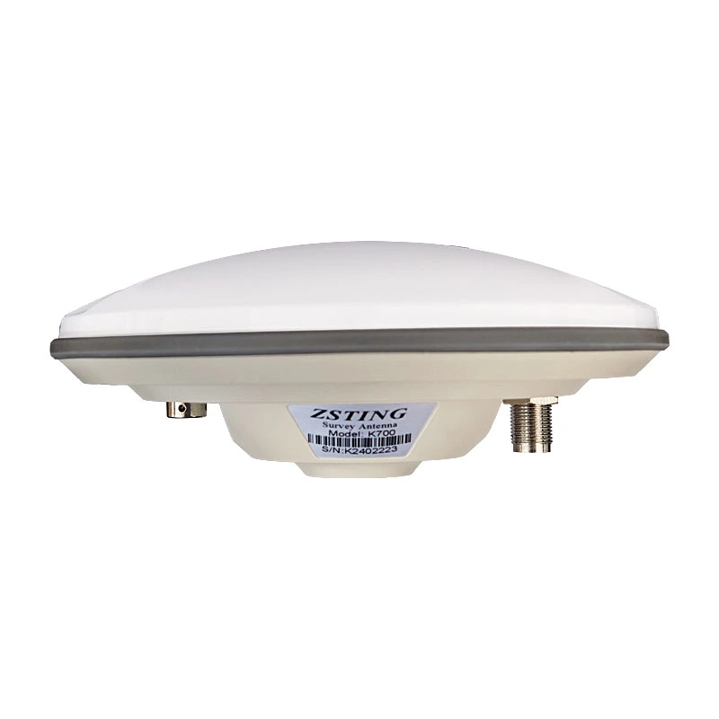
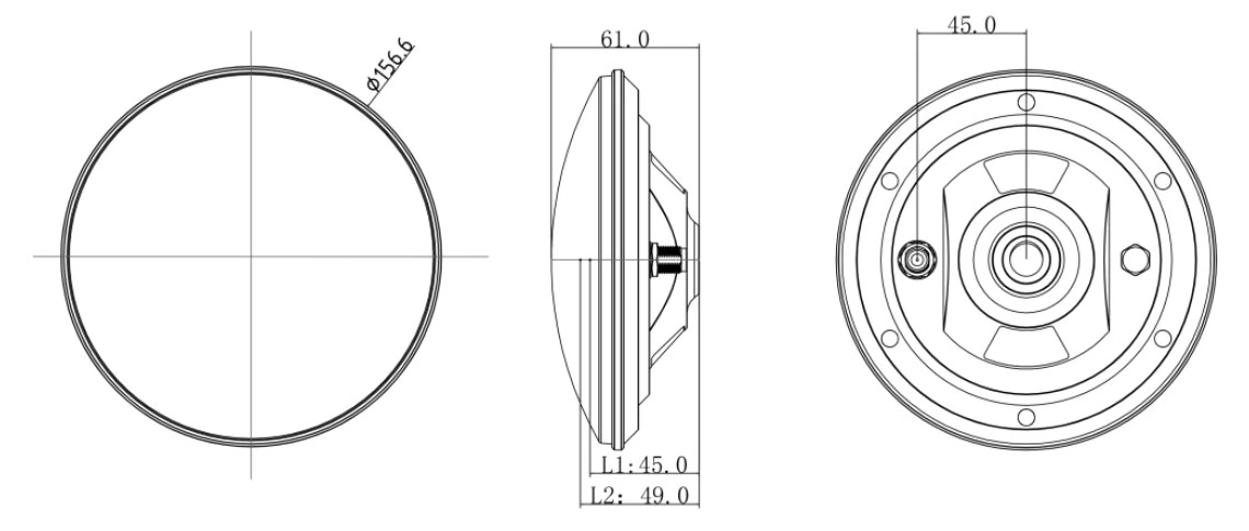
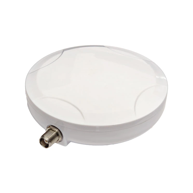
antenna parameters:
  |
|
Electrical
Characteristics
|
1
|
Frequency Range
|
GPS: L1, L2, L5
BDS: B1I, B2I, B3I, B2a, B2b
GLONASS: L1, L2, L3
Galileo: E1, E5b, E5a, E6
QZSS: L1, L2, L5, L6
IRNSS: L5
L-BAND
|
|
2
|
Output Standing Wave
|
≤2.0
|
|
3
|
Antenna Axial Ratio
|
≤3dB
|
|
4
|
Maximum Gain
|
5.5dBi
|
|
5
|
Phase Center
|
±2mm
|
|
6
|
Impedance
|
50Ω
|
|
7
|
Polarization Mode
|
RHCP
|
|
LNA
Specifications
|
1
|
LNA
|
L1:38±2dB
L2:38±2dB
|
|
2
|
VSWR
|
≤2.0
|
|
3
|
Noise Figure
|
≤1.8dB
|
|
4
|
In-band Flatness
|
1dB
|
|
5
|
Operating Voltage
|
3.3~12V
|
|
6
|
Operating Current
|
≤45 mA
|
|
7
|
Differential Transmission Delay
|
≤5ns
|
|
Structural Characteristics
|
1
|
Antenna Size
|
Φ159*61mm
|
|
2
|
Weight
|
≤380g
|
|
3
|
Connector Type
|
TNC
|
|
4
|
Thread Specification
|
Unified National Coarse (UNC) 5/8''×11 (Imperial)
|
|
5
|
Mounting Method
|
centering rod mounting
|
|
Environmental Conditions
|
1
|
Operating Temperature
|
-40℃~+85℃
|
|
2
|
Storage Temperature
|
-55℃~+85℃
|
|
3
|
Humidity
|
95% non-condensing
|
  |
|
Antenna
Characteristics
|
1
|
Operating Frequency
|
GPS: L1C/A, L1C, L2P, L2C, L5
BDS-2: B1I, B21, B31
BDS-3: B1I, B31, B1C, B2a, B2b
GLONASS: G1, G2, G3
Galileo: E1, E5b, E5a, E5AltBoC, E6c
QZSS: L1C/A, L2C, L5, L1C
SBAS: L1C/A
IRNSS: L5
|
|
2
|
Antenna Specifications
|
GPS, Bei Dou,GLONASS,GALILEO
|
|
3
|
Frequency Range
|
1165-1278/1559-1612MHz
|
|
4
|
V.S.W. R
|
≤2.0
|
|
5
|
Axial Ratio
|
Elevation angle 90 degrees: ≤3
Elevation angle 15 degrees: ≤5
|
|
6
|
Gain
|
Elevation angle 90 degrees: ≥6
Elevation angle 20 degrees: ≥0 (plane)
|
|
7
|
Front to back power
|
±60 degrees: ≥15dB
|
|
8
|
Phase Center (mm)
|
<2
|
|
9
|
Impendence
|
50Ω
|
|
10
|
Polarization
|
RHCP
|
|
LNA
|
1
|
LNA GAIN
|
38±2dB
|
|
2
|
V.S.W. R
|
<2
|
|
3
|
Noise Figure
|
<1.5
|
|
4
|
DC Voltage
|
3.3~18V
|
|
5
|
Current
|
<35 mA
|
|
Mechanical
Structure
|
1
|
Component Name
|
SPEC
|
|
2
|
Antenna Connector
|
TNC / SMA
|
|
3
|
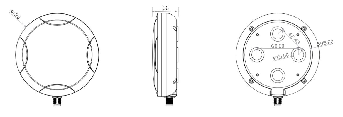
Antenna Dimensions
|
Φ120*38mm
|
|
4
|
weight
|
313.8g
|
|
5
|
PCB board
|
FR4
|
|
Environmental Characteristics
|
1
|
Operating Temperature
|
-40℃~+85℃, 10%~95% RH
|
|
2
|
Storage Temperature
|
-55℃~+100℃, 10%~95% RH
|
|
3
|
Vibration
|
Sine sweep @1.5mmAM
10~55Hz each Axis
|
|
picture
|
1
|
picture
|
|
|
|
Electrical
Characteristics
|
1
|
Operating Frequency
|
GPS: L1, L2, L5
BDS: B1I, B2I, B3I, B2a, B2b
GLONASS: L1, L2, L3
Galileo: E1, E5b, E5a, E6
QZSS: L1, L2, L5, L6
IRNSS: L5
|
GPS: L1, L2, L5
BDS: B1I, B2I, B3I, B2a, B2b
GLONASS: L1, L2, L3
Galileo: E1, E5b, E5a, E6
QZSS: L1, L2, L5, L6
IRNSS: L5
|
|
2
|
Frequency Range
|
1170-1278/1559-1612MHz
|
1170-1278/1559-1612MHz
|
|
3
|
V.S.W. R
|
≤2.0
|
≤2.0
|
|
4
|
Axial Ratio
|
Elevation at 90 degrees: ≤ 3,
Elevation at 15 degrees: ≤ 5
|
At elevation angle 90 degrees:
≤3, at elevation angle 15 degrees: ≤5
|
|
5
|
Gain
|
Elevation at 90 degrees: ≥ 6 dB,
Elevation at 20 degrees: ≥ 0 dB
|
At an elevation angle of 90 degrees:
≥6, at an elevation angle of 20 degrees: ≥0 plane
|
|
6
|
Phase Center
|
<2mm
|
<2
|
|
7
|
Impendence
|
50Ω
|
50Ω
|
|
8
|
Polarization
|
RHCP
|
RHCP
|
|
9
|
Out-of-Band Suppression
|
1268+100MHZ≥50db,
1170-100MHZ≥50db,
1602+100MHZ≥50db,
1561-100MHZ ≥50db.
|
1268+100MHZ≥50db,
1170-100MHZ≥50db,
1602+100MHZ≥50db,
1561-100MHZ ≥50db.
|
|
LNA
|
1
|
LNA GAIN
|
38±2dB
|
38±2dB
|
|
2
|
V.S.W. R
|
<2
|
<2
|
|
3
|
Noise Figure
|
<2.0
|
<2.0
|
|
4
|
DC Voltage
|
3.3~16V
|
3.3~16V
|
|
5
|
Current
|
<35 mA
|
<35 mA
|
|
Mechanical
Structure
|
1
|
Part Name
|
SPEC
|
SPEC
|
|
2
|
Antenna
|
FPC
|
FPC
|
|
3
|
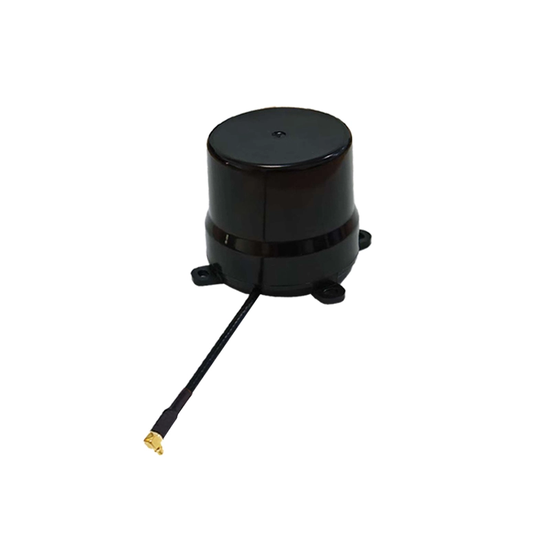
Antenna Dimensions
|
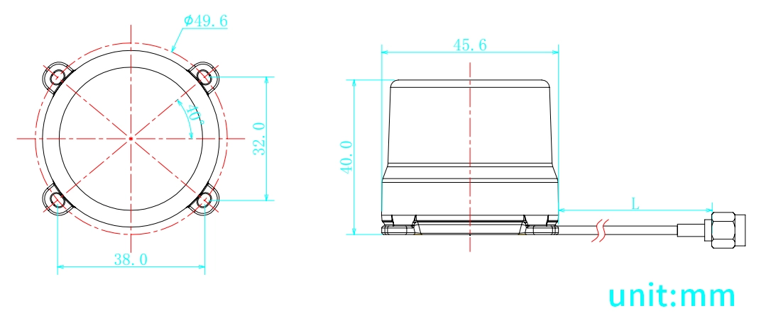
Φ45.6*40mm
|
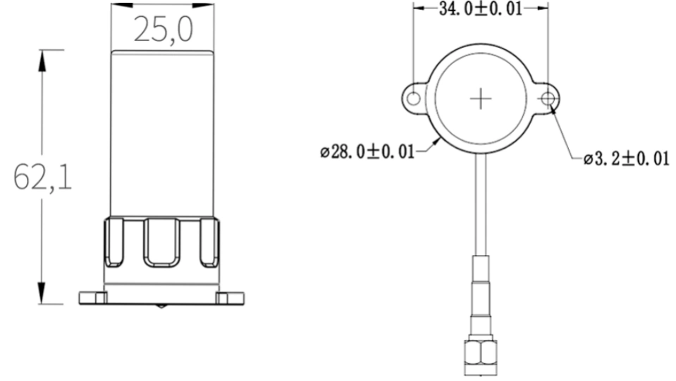
Φ62.1*25mm
|
|
4
|
Product Weight
|
25.8g
|
25.4g
|
|
5
|
Coaxial line
|
RG316 / RG1.13(customizable)
|
RG316 / RG1.13(customizable)
|
|
6
|
Line length
|
L=150mm / L=250mm(customizable)
|
L=150mm / L=250mm(customizable)
|
|
7
|
RF Output Interface
|
SMA-J / IPEX / MCX / MMCX(customizable)
|
SMA-J / IPEX / MCX / MMCX(customizable)
|
|
8
|
Antenna Housing
|
ABS+PC
|
ABS+PC
|
|
9
|
PCB Board
|
FR4
|
FR4
|
|
Environmental
Characteristics
|
1
|
Operating Temperature
|
-40℃~+85℃, 10%~95% RH
|
-40℃~+85℃, 10%~95% RH
|
|
2
|
Storage Temperature
|
-40℃~+85℃, 10%~95% RH
|
-40℃~+85℃, 10%~95% RH
|
|
3
|
Humidity
|
Sine sweep
@1.5mmAM 10~55Hz each Axis
|
Sine sweep
@1.5mmAM 10~55Hz each Axis
|
|
4
|
Vibration Resistance
|
95% No-condensing
|
95% No-condensing
|
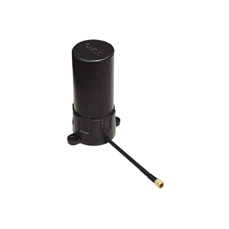
AK181:
AK161:
Packaging and Delivery:

High-Precision GNSS Receiver for UAVs and Precision Agriculture
The DALANG AK978H is a high-performance GNSS receiver featuring chip-level RTK and dual-antenna heading technology, delivering native centimeter-level positioning accuracy. With multi-band, multi-system signal reception capability and full compatibility with mainstream industrial data transmission protocols, it excels in high-precision applications such as UAV navigation, precision agriculture, autonomous driving, and surveying.
Real-Time RTK & Heading Engine
The integrated advanced anti-interference unit ensures reliable and accurate positioning data even in complex electromagnetic environments. It provides real-time centimeter-level positioning and precise heading information to meet the high-precision requirements of autonomous equipment.
Designed for Industrial Applications
Widely compatible with mainstream industrial standards for seamless integration into various systems. Equipped with an industrial-grade 1W data radio and supporting 9-36V wide voltage input, it is the ideal positioning and heading solution for UAVs, agricultural machinery, and system integrators.
Reliable in Harsh Environments
Featuring a rugged aluminum alloy shell, IP66 rating, and powerful anti-interference capabilities, it ensures stable performance in challenging environments such as urban areas, mountains, and farmlands.
Product Advantages
-
Full-Constellation RTK & Dual-Antenna Heading
Supports all major satellite systems for centimeter-level positioning and high-precision heading
-
Industrial Standard Compatibility
Fully compatible with industrial standard protocols, built-in data radio, wide voltage input, suitable for field and mobile applications
-
Exceptional Stability
Advanced anti-jamming technology and IP66 rating ensure continuous reliable operation in complex environments
-
High Performance & Easy Integration
Compact size, fast initialization, easy integration into various systems
Ready to upgrade your UAV or agricultural system with high-precision positioning? Choose DALANG AK978H for a new era of accuracy.
About Us
DALANG is a dedicated manufacturer of high-performance GNSS modules and RTK positioning solutions, serving industries such as UAV navigation, precision agriculture, and geospatial mapping. With a clear focus on accuracy, reliability, and integration flexibility, we support both standard and custom applications across global markets. Our product lines are engineered to meet the evolving demands of real-time positioning with support for multiple GNSS constellations, including GPS, GLONASS, BDS, and Galileo.
Our production facility spans 2,500㎡ and includes advanced SMT lines, in-house R&D labs, and full functional testing for every unit shipped. With a team of 30+ GNSS engineers, we design and manufacture over 200,000 GNSS receivers and modules annually. Certified to ISO9001:2015, and compliant with CE and RoHS standards, we follow a strict quality assurance process from prototyping through mass production. We also provide firmware updates, system integration support, and full lifecycle product documentation.
Trusted by partners in over 30 countries, DALANG delivers fast, scalable manufacturing with personalized technical support. Our streamlined collaboration model—covering inquiry, consultation, prototyping, and delivery—ensures efficiency from first contact to deployment. Whether you're sourcing off-the-shelf GNSS hardware or launching a customized solution, DALANG is your dependable partner for accurate, cost-effective positioning systems.
FAQ
1. Who are we?
We are DALANG, a specialized manufacturer of GNSS modules and RTK positioning systems based in China, with a focus on high-precision solutions for UAVs, surveying, and smart agriculture.
2. How can we guarantee quality?
All products undergo strict multi-stage quality control, including SMT production, functional testing, and 100% final inspection. We are ISO9001:2015 certified and follow international compliance standards such as CE and RoHS.
3. What can you buy from us?
You can purchase GNSS receivers, RTK modules, base stations, antennas, flight control positioning systems, and other GNSS-related components and accessories.
4. Why should you buy from us not from other suppliers?
We combine strong in-house R&D, flexible OEM/ODM support, industrial-grade quality assurance, and fast global delivery. Our expertise in GNSS RTK ensures stable, accurate, and scalable solutions tailored to your specific use case.
5. What services can we provide?
We offer OEM/ODM customization, technical consulting, firmware support, prototyping, and global after-sales service. Our team works closely with international clients to ensure efficient communication and long-term support.





