 丨 Product Introduction
1. Technology: Based on UM982, it supports full frequency RTK, dual antennas, and high-precision positioning in harsh environments.
2. Multi system compatibility: Receive signals from multiple satellite systems such as BDS to improve coverage and accuracy.
3. Positioning ability: Four mode RTK, fast and accurate positioning in various environments.
4. Measurement function: differential positioning, vector attitude measurement, providing accurate position and direction.
丨 Specification parameters
|
Chip
characteristics
|
chip
|
UM982
|
|
Working mode
|
BDS: B1I、B2I、B3I
GPS: L1C/A、L2P (Y)、L2C、L5
GLONASS: L1、L2
Galileo: E1、E5a、E5b
QZSS: L1、L2、L5
|
|
Receiving channel
|
1408 channel
|
|
Accuracy
|
Single point positioning (RMS)
|
Plane: 1.5m
|
|
Elevation: 2.5m
|
|
DGPS(RMS)
|
Plane: 0.4m
|
|
Elevation: 0.8m
|
|
RTK(RMS)
|
Flat: 0.8cm+1ppm
|
|
Elevation: 1.5cm+1ppm
|
|
Directional accuracy (RMS)
|
0.2 degrees/1m baseline
|
|
Time accuracy (RMS)
|
20 ns
|
|
Speed accuracy (RMS)
|
0.2 m/s
|
|
Observation accuracy (RMS)
|
BDS
|
GPS
|
GLONASS
|
Galileo
|
|
B1I/B1C/L1 C/A/E1/G1 pseudorange
|
10cm
|
10cm
|
10cm
|
10cm
|
|
B1I/B1C/ L1 C/A/E1/G1 Carrier Phase
|
1mm
|
1mm
|
1mm
|
1mm
|
|
B3I/L2P(Y)/L2C/G2 pseudorange
|
10cm
|
10cm
|
10cm
|
10cm
|
|
B3I/L2P(Y)/L2C/G2 Carrier Phase
|
1mm
|
1mm
|
1mm
|
1mm
|
|
B2I/ L5/E5a/E5b pseudorange
|
10cm
|
10cm
|
10cm
|
10cm
|
|
B2I/ L5/E5a/E5b Carrier Phase
|
1mm
|
1mm
|
1mm
|
1mm
|
|
Time To First
Fix TTFF
|
cold boot
|
< 20 s
|
|
Initialization time
|
< 5 s ( Typical values)
|
|
Initialize reliability
|
> 99.9%
|
|
Output data
|
Baud rate
|
115200bps (default) [Optional: 4800-921600]
|
|
Output interface
|
TTL/USB
|
|
Output Protocol
|
NMEA0183、RTCM 3.3
|
|
Data update rate
|
1Hz-20Hz (default 1Hz)
|
|
Differential data
|
RTCM 3.3/3.2/3.1/3.0
|
|
Carrier phase output
|
Support, output RAWX statement
|
|
FLASH
|
built-in
|
|
Electrical
specifications
|
working voltage
|
5V DC
|
|
power waste
|
<800mW
|
|
Physical
parameters
|
size
|
36.58*25.66*7.6mm
|
|
weight
|
6.0g
|
|
Connector
|
TYPE-C/ GH1.25mm 6pin
|
|
Antenna connector
|
MMCX*2
|
|
Environment
|
working temperature
|
-35℃-80℃
|
|
Storage temperature
|
-40℃-85℃
|
丨 product mix
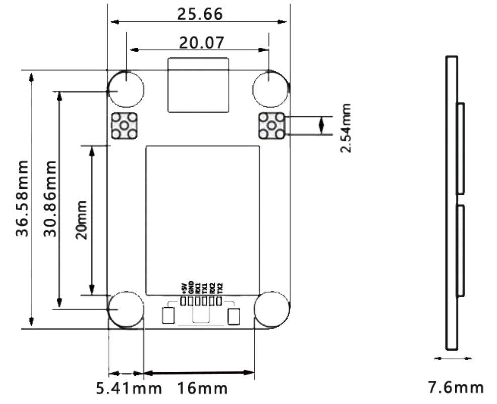
Table 1 PIN Functionality
|
NO.
|
Signal name
|
Signal Description
|
|
1
|
VCC
|
Power input, DC+5V
|
|
2
|
GND
|
grounding
|
|
3
|
RX1
|
Main serial port (COM1) data transmission, output NMEA0183 format positioning results when configured as "mobile
station", and output RTCM2. x/3. x format differential data stream when configured as "reference station".
|
|
4
|
TX1
|
Main serial port (COM1) data reception, configure command input port.
|
|
5
|
RX2
|
COM2 output interface
|
|
6
|
TX2
|
COM2 differential serial port (COM2) data input, only valid when configured as "mobile station", accepts RTCM2. x/3. x format differential data input.
|
|
7
|
TYPE-C
|
COM3 output interface
|
Table 2 Interface Characteristics
|
NO.
|
Name
|
Symbol
|
Minimum value
|
Typical values
|
Maximum value
|
Unit
|
|
1
|
Main power supply
|
Vcc
|
2.7
|
5.0
|
5.5
|
V
|
|
2
|
RF port feeding
|
VRF
|
3.0
|
3.1
|
3.3
|
V
|
|
3
|
Input high level
|
VIH
|
2.0
|
|
|
V
|
|
4
|
Input low level
|
VIL
|
|
|
0.7
|
V
|
|
5
|
Output high level
|
VOH
|
3.2
|
|
|
V
|
|
6
|
Input low level
|
VOL
|
|
|
0.1
|
V
|
|
7
|
Main serial port baud rate
|
Baud
|
|
115200
|
|
bps
|
|
8
|
Differential wave
|
Baud
|
|
115200
|
|
bps
|
Centimeter-Level GNSS RTK Positioning with Full Satellite Support
The DALANG UM982 RTK module offers full GNSS system compatibility (GPS, BDS, GLONASS, Galileo) and high-precision GNSS RTK positioning. With sub-inch accuracy, it is built for UAVs, robotics, and smart vehicles. If you're building an autonomous system that relies on precision, this GPS board ensures mission success.
Optimized for Autonomous Driving and UAV Navigation
This RTK GPS module is ideal for autonomous cars, drones, and machine guidance systems that require real-time, high-accuracy data. Its high update rate, strong signal acquisition, and low latency make it a top-performing RTK module in critical autopilot functions.
Anti-Interference Technology for Stable Operation
The UM982 is equipped with industry-grade anti-interference features that maintain signal integrity in challenging RF environments. For professional users seeking reliable GNSS RTK positioning under load, this GPS board provides exceptional filtering and signal protection.
Low Power Design for Long-Term Field Use
Built with a power-efficient architecture, the UM982 RTK module is perfect for battery-powered UAVs and off-grid autonomous vehicles. It minimizes power draw without compromising performance—making it a strong fit for scalable RTK GPS applications.
Product Advantages
Centimeter-Level GNSS RTK Accuracy
With full satellite system access and GNSS RTK technology, this RTK module delivers high-precision results for drones, vehicles, and agricultural robots. Ideal for teams working on advanced autopilot solutions.
Anti-Interference Stability in Any Environment
Designed with advanced anti-jamming features, this GPS board maintains consistent data in EMI-heavy zones. It’s an excellent choice for professional integrators seeking durable and accurate RTK GPS hardware.
Power-Efficient for UAV and Field Robotics
The UM982’s low-power design supports long-range or long-duration missions. A reliable RTK module that enables extended operation times without compromising GNSS RTK accuracy.
Multi-System GNSS Support with RTK GPS Performance
Built for precision, this RTK GPS solution works across GNSS constellations with dual-band positioning. Whether you're prototyping or scaling, this GPS board offers plug-and-play performance.
Developing UAVs or autonomous systems? Buy the DALANG UM982 GNSS RTK board now and power your navigation with industrial-grade precision and stability.
About Us
DALANG is a dedicated manufacturer of high-performance GNSS modules and RTK positioning solutions, serving industries such as UAV navigation, precision agriculture, and geospatial mapping. With a clear focus on accuracy, reliability, and integration flexibility, we support both standard and custom applications across global markets. Our product lines are engineered to meet the evolving demands of real-time positioning with support for multiple GNSS constellations, including GPS, GLONASS, BDS, and Galileo.
Our production facility spans 2,500㎡ and includes advanced SMT lines, in-house R&D labs, and full functional testing for every unit shipped. With a team of 30+ GNSS engineers, we design and manufacture over 200,000 GNSS receivers and modules annually. Certified to ISO9001:2015, and compliant with CE and RoHS standards, we follow a strict quality assurance process from prototyping through mass production. We also provide firmware updates, system integration support, and full lifecycle product documentation.
Trusted by partners in over 30 countries, DALANG delivers fast, scalable manufacturing with personalized technical support. Our streamlined collaboration model—covering inquiry, consultation, prototyping, and delivery—ensures efficiency from first contact to deployment. Whether you're sourcing off-the-shelf GNSS hardware or launching a customized solution, DALANG is your dependable partner for accurate, cost-effective positioning systems.
FAQ
What makes your GNSS receiver suitable for UAV navigation?
Our UM982 GNSS receiver supports multi-constellation satellite systems and dual-antenna RTK positioning to deliver centimeter-level accuracy and robust signal performance, essential for UAV flight safety and precision navigation in diverse environments.
Can I customize the GNSS module’s firmware or hardware to fit specific project needs?
Yes, we offer OEM/ODM customization, including firmware updates and hardware integration support. Our experienced R&D team works closely with customers to tailor the GNSS receiver and related components for individual project requirements.
How do you ensure the quality and reliability of your GPS systems for sale?
We follow strict quality control processes, including advanced SMT production, functional testing, and 100% final inspection. Our products, including GPS systems for sale, comply with ISO9001:2015, CE, and RoHS standards to guarantee durability and stable performance.
What are the recommended communication options for integrating your RTK module?
Our UM982 module features output interfaces via TTL and USB supporting baud rates from 4800 to 921600 bps. It uses standard NMEA0183 and RTCM 3.x protocols, allowing easy integration with diverse autopilot and navigation systems requiring precise RTK GPS data.