丨 Product Introduction
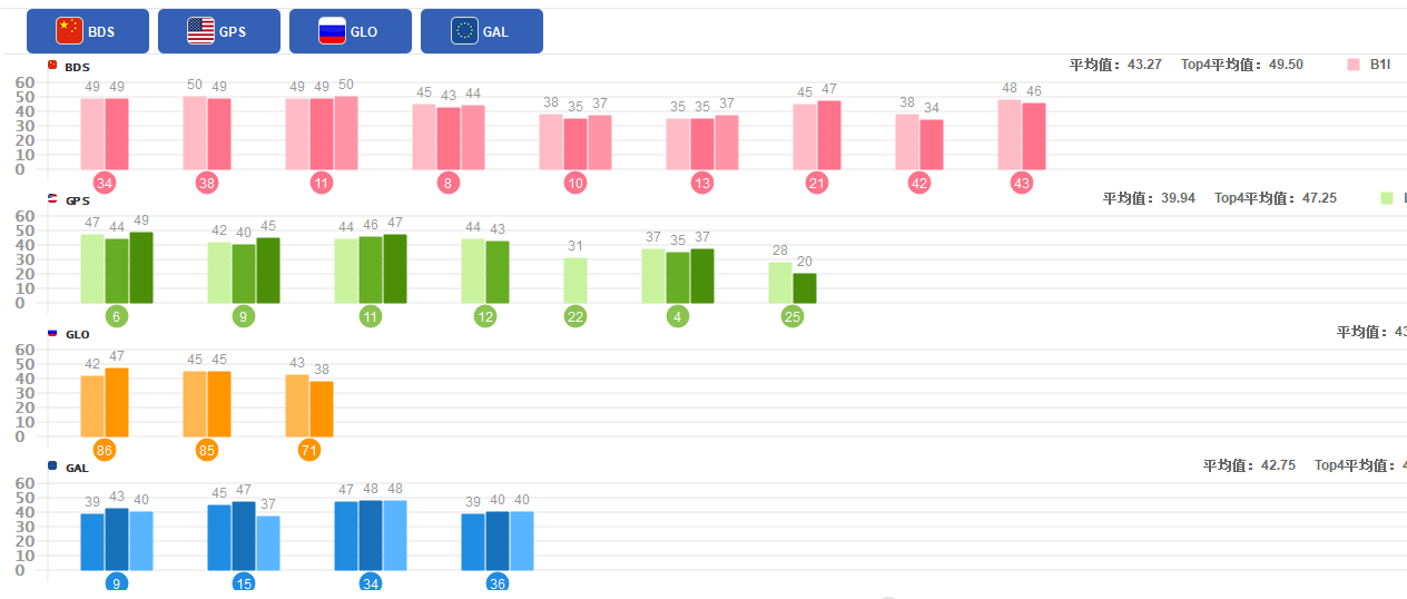
1. Multi system compatibility: It can receive and process signals from multiple satellite navigation systems such as BDS and GPS, enhancing coverage and positioning accuracy.
2. Positioning scheme: The whole system and frequency on-chip RTK scheme has strong integration capability and fast positioning initialization.
3. Data rate: 20 Hz data output rate, high-performance processing, adaptable to dynamic environments, suitable for drones, etc.
4. Real time positioning: Real time RTK initialization technology achieves high-precision positioning in a few seconds, improving the success rate and stability of initialization in obstacle environments.
丨 Specification parameters
|
Chip
specifications
|
chip
|
UM980
|
|
working frequency
|
BDS: B1I B2I B3I B1C B2a B2b
GPS: L1 C/A L1C L2P (Y) L2C L5
GLONASS: L1 L2
Galileo: E1 E5a E5b E6
QZSS: L1 L2 L5 L6
|
|
Receiving channel
|
1408 channel
|
|
Accuracy
|
Single point positioning (RMS)
|
Plane: 1.5m
|
|
Elevation: 2.5m
|
|
DGPS(RMS)
|
Plane: 0.4m
|
|
Elevation: 0.8m
|
|
RTK(RMS)
|
Flat: 0.8cm+1ppm
|
|
Elevation: 1.5cm+1ppm
|
|
Observation accuracy (RMS)
|
BDS
|
GPS
|
GLONASS
|
Galileo
|
|
B1I/B1C/L1C/L1 C/A/E1/G1 pseudorange
|
10cm
|
10cm
|
10cm
|
10cm
|
|
B1I/B1C/L1C/L1 C/A/E1/G1 Carrier Phase
|
1mm
|
1mm
|
1mm
|
1mm
|
|
B3I/L2P(Y)/L2C/G2 pseudorange
|
10cm
|
10cm
|
10cm
|
10cm
|
|
B3I/L2P(Y)/L2C/G2
Carrier Phase
|
1mm
|
1mm
|
1mm
|
1mm
|
|
B2I/B2a/ B2b/L5/E5a/E5b pseudorange
|
10cm
|
10cm
|
10cm
|
10cm
|
|
B2I/B2a/ B2b/L5/E5a/E5b Carrier Phase
|
1mm
|
1mm
|
1mm
|
1mm
|
|
Time accuracy (RMS)
|
10 ns
|
|
Speed accuracy (RMS)
|
0.03 m/s
|
|
Start Time
|
cold boot
|
< 10 s
|
|
Initialization time
|
<5s (typical value)
|
|
Initialize reliability
|
> 99.9%
|
|
Output data
|
Baud rate
|
115200bps (default) [Optional: 4800-921600]
|
|
Output interface
|
TTL
|
|
Output Protocol
|
NMEA0183、RTCM 3.3
|
|
update frequency
|
1Hz-20Hz (default 1Hz)
|
|
Differential
data
|
Differential data
|
RTCM 3.3/3.2/3.1/3.0
|
|
Carrier phase output
|
Support, output RAWX statement
|
|
FLASH
|
built-in
|
|
Electrical
specifications
|
working voltage
|
5V DC
|
|
power waste
|
800mW
|
|
Physical
parameters
|
size
|
36.58*25.66*7.6mm
|
|
weight
|
5.8g
|
|
Connector
|
TYPE-C/GH1.25mm 6pin
|
|
Antenna connector
|
MMCX
|
|
Environment
|
working temperature
|
-35℃-80℃
|
|
Storage temperature
|
-40℃-95℃
|
丨 product mix
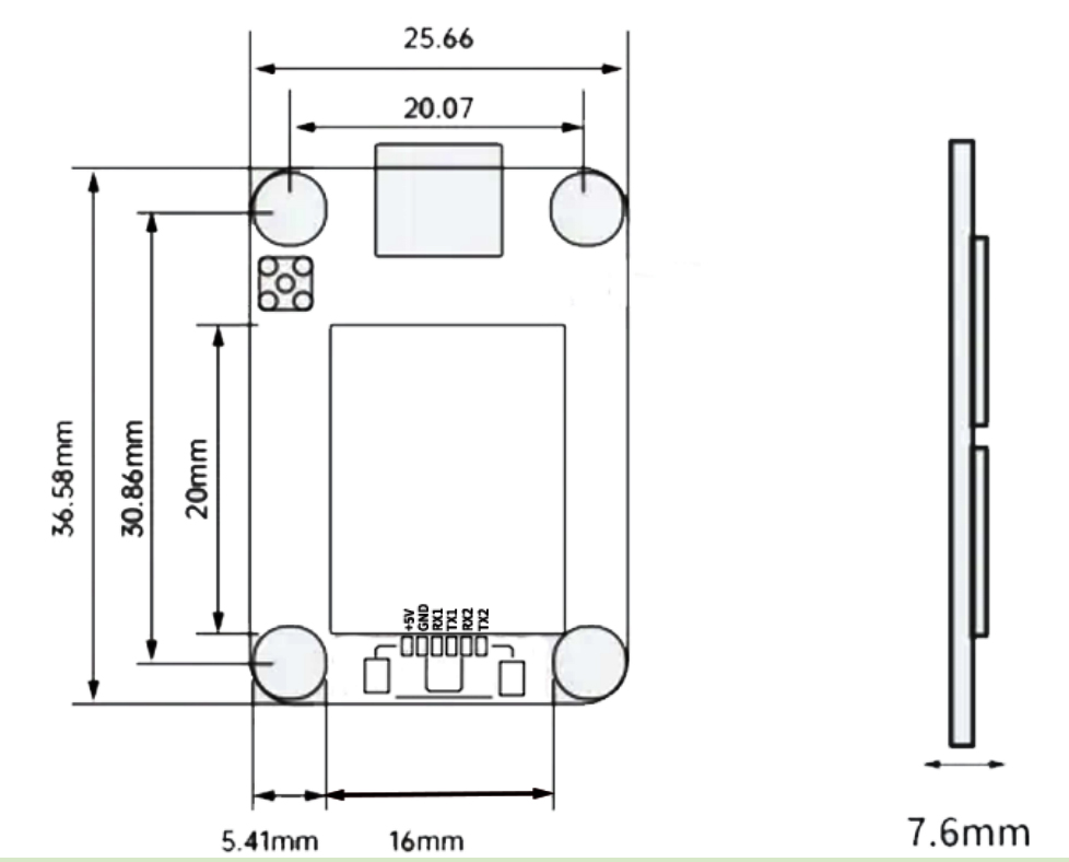
Table 1 PIN Functionality
|
NO.
|
Signal name
|
Signal Description
|
|
1
|
VCC
|
Power input, DC+5V
|
|
2
|
GND
|
grounding
|
|
3
|
RX1
|
Main serial port (COM1) data transmission, output NMEA0183
format positioning results when configured as "mobile
station", and output RTCM2. x/3. x format differential data stream when configured as "reference station".
|
|
4
|
TX1
|
Main serial port (COM1) data reception, configure command
input port.
|
|
5
|
RX2
|
COM2 output interface
|
|
6
|
TX2
|
COM2 differential serial port (COM2) data input, only valid when configured as "mobile station", accepts RTCM2. x/3. x format differential data input.
|
|
7
|
TYPE-C
|
COM3 output interface
|
Table 2 Interface Characteristics
|
NO.
|
Name
|
Symbol
|
Minimum value
|
Typica values
|
Maximumvalue
|
Unit
|
|
1
|
Main power supply
|
Vcc
|
2.7
|
5.0
|
5.5
|
V
|
|
2
|
RF port feeding
|
VRF
|
3.0
|
3.1
|
3.3
|
V
|
|
3
|
Input high level
|
VIH
|
2.0
|
|
|
V
|
|
4
|
Input low level
|
VIL
|
|
|
0.7
|
V
|
|
5
|
Output high level
|
VOH
|
3.2
|
|
|
V
|
|
6
|
Input low level
|
VOL
|
|
|
0.1
|
V
|
|
7
|
Main serial port baud rate
|
Baud
|
|
115200
|
|
bps
|
|
8
|
Differential wave
|
Baud
|
|
115200
|
|
bps
|
High-Precision GNSS Engine for UAV and Agriculture
The DALANG AK315 FPV GPS module is a multi-frequency, multi-system GNSS board built for centimeter-level accuracy. Supporting GPS, BDS, GLONASS, and Galileo, this powerful RTK solution is ideal for UAV navigation, smart farming, and geospatial measurement tasks.
Advanced RTK Engine for Real-Time Positioning
With its integrated multi-frequency RTK engine, the AK315 provides real-time corrections and stable GNSS data across varying terrains. Whether mounted on an autonomous drone or tractor, this FPV module ensures pinpoint location tracking essential for precision workflows.
Designed for Open-Source Flight Controllers and Integrators
Fully compatible with open-source systems such as ArduPilot, PX4, and custom builds, the AK315 FPV drone GPS module supports flexible deployment and long-term scalability. It’s the perfect board for drone developers and integrators looking for a stable FPV receiver module.
Reliable in Challenging Environments
With robust anti-interference performance and high signal sensitivity, the AK315 excels in urban, mountainous, or tree-covered environments. A proven FPV GPS module for operators who demand stable GNSS output in real-world conditions.
Product Advantages
Multi-Frequency GNSS Support for Maximum Precision
This FPV GPS module supports L1/L2/L5 bands and multiple constellations, enabling real-time sub-inch positioning. An essential FPV receiver module for developers seeking professional-grade tracking.
Optimized for Open-Source and OEM Use
The AK315 works seamlessly with F4/F7 flight controllers and open-source stacks, making it one of the most versatile FPV drone GPS module options on the market.
Stable Performance in Harsh Environments
Whether you fly over dense forests or drive through interference zones, this FPV GPS module delivers reliable RTK corrections and consistent tracking. It’s the dependable FPV module for demanding terrain.
Lightweight, Low-Power, and Easy to Integrate
The small footprint and power efficiency of the AK315 make it an ideal choice for drones or AGV systems. It’s a compact FPV receiver module ready for high-volume applications.
Need centimeter-level accuracy for your UAV or farming system? Order the DALANG AK315 GNSS board today and upgrade your flight control or mapping project with real-time RTK performance.
About Us
DALANG is a dedicated manufacturer of high-performance GNSS modules and RTK positioning solutions, serving industries such as UAV navigation, precision agriculture, and geospatial mapping. With a clear focus on accuracy, reliability, and integration flexibility, we support both standard and custom applications across global markets. Our product lines are engineered to meet the evolving demands of real-time positioning with support for multiple GNSS constellations, including GPS, GLONASS, BDS, and Galileo.
Our production facility spans 2,500㎡ and includes advanced SMT lines, in-house R&D labs, and full functional testing for every unit shipped. With a team of 30+ GNSS engineers, we design and manufacture over 200,000 GNSS receivers and modules annually. Certified to ISO9001:2015, and compliant with CE and RoHS standards, we follow a strict quality assurance process from prototyping through mass production. We also provide firmware updates, system integration support, and full lifecycle product documentation.
Trusted by partners in over 30 countries, DALANG delivers fast, scalable manufacturing with personalized technical support. Our streamlined collaboration model—covering inquiry, consultation, prototyping, and delivery—ensures efficiency from first contact to deployment. Whether you're sourcing off-the-shelf GNSS hardware or launching a customized solution, DALANG is your dependable partner for accurate, cost-effective positioning systems.
FAQ
1. Who are we?
We are DALANG, a specialized manufacturer of GNSS modules and RTK positioning systems based in China, with a focus on high-precision solutions for UAVs, surveying, and smart agriculture.
2. How can we guarantee quality?
All products undergo strict multi-stage quality control, including SMT production, functional testing, and 100% final inspection. We are ISO9001:2015 certified and follow international compliance standards such as CE and RoHS.
3. What can you buy from us?
You can purchase GNSS receivers, RTK modules, base stations, antennas, flight control positioning systems, and other GNSS-related components and accessories.
4. Why should you buy from us not from other suppliers?
We combine strong in-house R&D, flexible OEM/ODM support, industrial-grade quality assurance, and fast global delivery. Our expertise in GNSS RTK ensures stable, accurate, and scalable solutions tailored to your specific use case.
5. What services can we provide?
We offer OEM/ODM customization, technical consulting, firmware support, prototyping, and global after-sales service. Our team works closely with international clients to ensure efficient communication and long-term support.