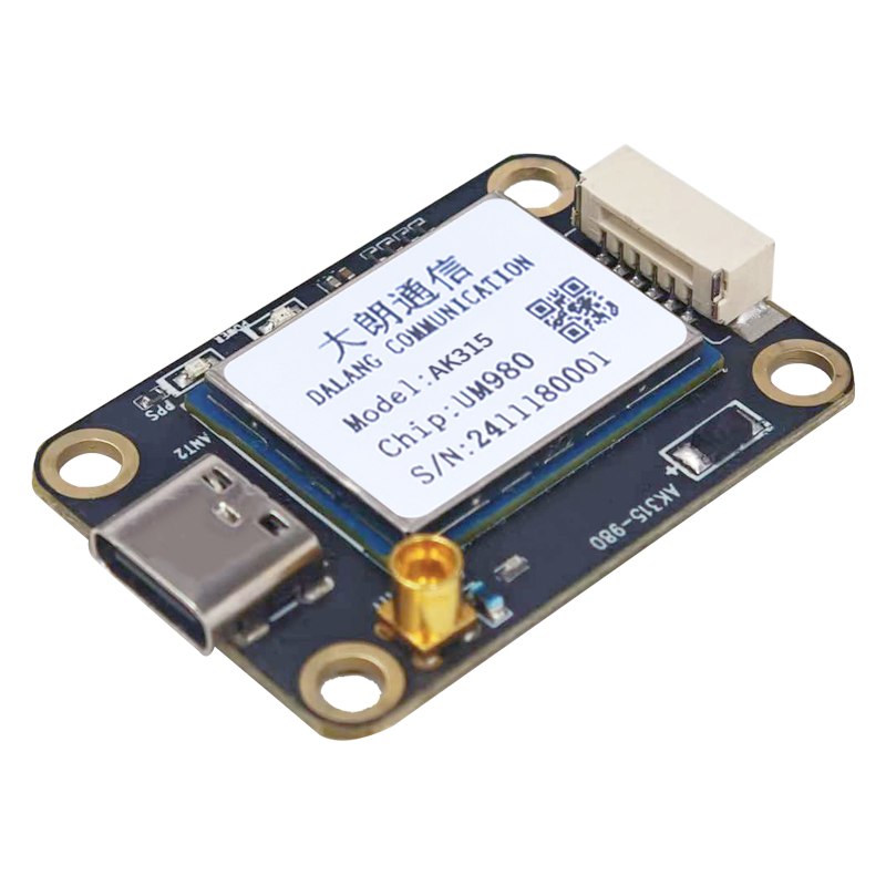
丨 Product IntroductionWhy did you choose this plan?UM980: Focused on high-precision positioning (8mm+1ppm), suitable for surveying and agricultural machinery navigation
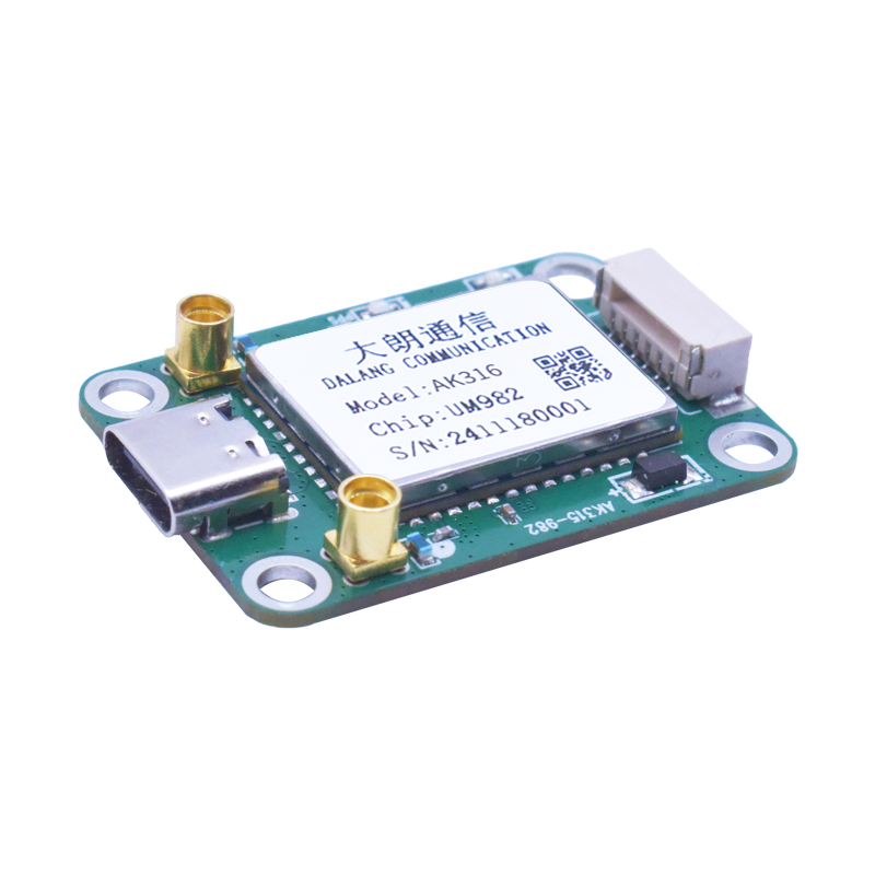
UM982: Enhanced heading measurement (0.2 ° accuracy), suitable for autonomous driving and ship orientation
UM980 is a professional level solution designed specifically for centimeter level positioning and precise orientation, providing full constellation RTK positioning (accuracy 8mm+1ppm), while UM982 achieves dual antenna heading measurement (accuracy 0.2 °). Suitable for high-precision application scenarios such as unmanned aerial vehicle surveying and agricultural automation.
Characteristic:1. Multi system compatibility: It can receive and process signals from multiple satellite navigation systems such as BDS and GPS, enhancing coverage and positioning accuracy.
2. Positioning scheme: The whole system and frequency on-chip RTK scheme has strong integration capability and fast positioning initialization.
3. Data rate: 20 Hz data output rate, high-performance processing, adaptable to dynamic environments, suitable for drones, etc.
4. Real time positioning: Real time RTK initialization technology achieves high-precision positioning in a few seconds, improving the success rate and stability of initialization in obstacle environments.
丨 Specification parameters
| |
|
|
AK315
|
AK316
|
| picture |
1
|
picture
|
|
|
|
Chip
characteristics
|
2
|
Chip
|
UM980
|
UM982
|
|
3
|
Operating Frequency
|
BDS: B1I B2I B3I B1C B2a B2b
GPS: L1 C/A L1C L2P (Y) L2C L5
GLONASS: L1 L2
Galileo: E1 E5a E5b E6
QZSS: L1 L2 L5 L6
|
BDS: B1I、B2I、B3I
GPS: L1C/A、L2P (Y)、L2C、L5
GLONASS: L1、L2
Galileo: E1、E5a、E5b
QZSS: L1、L2、L5
|
|
4
|
Receiving channel
|
1408 channel
|
1408 channel
|
|
Accuracy
|
1
|
Single point positioning (RMS)
|
Plane: 1.5m
|
Plane: 1.5m
|
|
2
|
Elevation: 2.5m
|
Elevation: 2.5m
|
|
3
|
DGPS(RMS)
|
Plane: 0.4m
|
Plane: 0.4m
|
|
4
|
Elevation: 0.8m
|
Elevation: 0.8m
|
|
5
|
RTK(RMS)
|
Flat: 0.8cm+1ppm
|
Flat: 0.8cm+1ppm
|
|
6
|
Elevation: 1.5cm+1ppm
|
Elevation: 1.5cm+1ppm
|
|
7
|
time accuracy
(RMS)
|
10ns
|
20ns
|
|
8
|
Speed accuracy
(RMS)
|
0.03m/s
|
0.2 m/s
|
|
Start Time
|
1
|
cold start
|
<10s
|
<20s
|
|
2
|
initialization time
|
<5s(Typical value)
|
<5s (typical value)
|
|
3
|
Initialize reliability
|
>99.9%
|
>99.9%
|
|
Output data
|
1
|
Baud rate
|
115200bps (default) [Optional: 4800-921600]
|
115200bps (default) [Optional: 4800-921600]
|
|
2
|
output interface
|
TTL/USB
|
TTL/USB
|
|
3
|
Output Protocol
|
NMEA0183、RTCM 3.3
|
NMEA0183、RTCM 3.3
|
|
4
|
update frequency
|
1Hz-20Hz(default 1Hz)
|
1Hz-20Hz (default 1Hz)
|
|
Differential
data
|
1
|
Differential data
|
RTCM 3.3/3.2/3.1/3.0
|
RTCM 3.3/3.2/3.1/3.0
|
|
2
|
Carrier phase output
|
Support, output RAWX statement
|
Support, output RAWX statement
|
|
3
|
FLASH
|
built-in
|
built-in
|
|
Electrical
specifications
|
1
|
working voltage
|
5V DC
|
5V DC
|
|
2
|
power consumption
|
800mW
|
<800mW
|
|
Physical
parameters
|
1
|
size
|
36.58*25.66*7.6mm
|
36.58*25.66*7.6mm
|
|
2
|
weight
|
5.8g
|
6.0g
|
|
4
|
Connector
|
TYPE-C/GH1.25mm 6pin
|
TYPE-C/GH1.25mm 6pin
|
|
5
|
antenna connector
|
MMCX
|
MMCX*2
|
|
Environment
|
1
|
operation temperature
|
-35℃-80℃
|
-35℃-80℃
|
|
2
|
storage temperature
|
-40℃-95℃
|
-40℃-85℃
|
|
picture
parameter
|
|
|
|

|
|
|
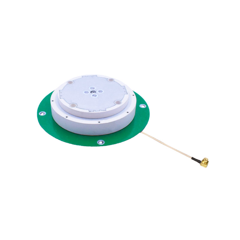
Product name
|
AK610
|
AK613
|
AK810
|
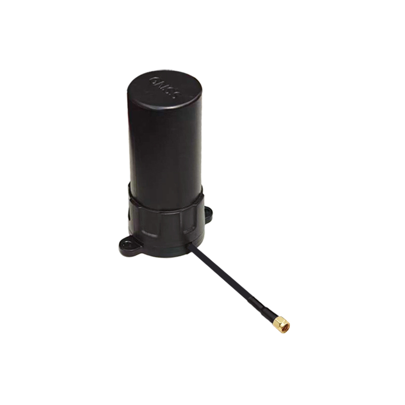
AK711
|
AK161
|
|
Antenna
|
Operating Frequency
|
GPS: L1C/A, L1C, L2P, L2C, L5
BDS-2: B1I, B21, B31
BDS-3: B1I, B31, B1C, B2a, B2b
GLONASS: G1, G2, G3
Galileo: E1, E5b, E5a, E5AltBoC, E6c
QZSS: L1C/A, L2C, L5, L1C
SBAS: L1C/A
IRNSS: L5
|
GPS: L1C/A, L1C, L2P, L2C, L5
BDS-2: B1I, B21, B31
BDS-3: B1I, B31, B1C, B2a, B2b
GLONASS: G1, G2, G3
Galileo: E1, E5b, E5a, E5AltBoC, E6c
QZSS: L1C/A, L2C, L5, L1C
SBAS: L1C/A
IRNSS: L5
|
GPS: L1, L2, L5
BDS: B1I, B2I, B3I, B2a, B2b
GLONASS: L1, L2, L3
Galileo: E1, E5b, E5a, E6
QZSS: L1, L2, L5, L6
IRNSS: L5
|
GPS: L1/L2/L5
BDS: B1/B2/B3
GLONASS: L1/L2
GALILEO: E1
|
GPS:
L1:1575 .42+1.023MHz.
L2:1227+1.023MHz,
L5:1176+1.023MHz
BDS:
B1:1561+2.046MHz,
B2:1207 +2.046MHz.
B3:1268+10.23MHz.
GLONASS
L1=1602+0 5625*k(MHz)
L2=1246+0.4375*k(MHz),
GALILE:
E1: 1575
|
|
V.S.W.R
|
≤2.0
|
≤2.0
|
≤2.0
|
≤2.0
|
≤2.0
|
|
Axial Ratio
|
Elevation 90 degrees: ≤3, Elevation 15 degrees: ≤5
|
Elevation 90 degrees: ≤3, Elevation 15 degrees: ≤5
|
Elevation angle of 90 degrees: ≤ 3, elevation angle of 15 degrees: ≤ five
|
Elevation at 90 degrees: ≤ 3 dB, Elevation at 15 degrees: ≤ 5 dB
|
At elevation angle 90 degrees: ≤3, at elevation angle 15 degrees: ≤5
|
|
Gain
|
Elevation 90 degrees: ≥6, Elevation 20 degrees: ≥0
|
Elevation 90 degrees: ≥6, Elevation 20 degrees: ≥0
|
Elevation angle of 90 degrees: ≥ 6, elevation angle of 20 degrees: ≥ 0 plane)
|
Elevation at 90 degrees: ≥ 6 dB, Elevation at 20 degrees: ≥ 0 dB
|
At an elevation angle of 90 degrees: ≥6, at an elevation angle of 20 degrees: ≥0 plane
|
|
Front to back Power
|
±60 degrees: ≥15dB
|
±60 degrees: ≥15dB
|
± 60 degrees ≥ 15dB
|
±60 degrees: ≥ 15 dB
|
±60 degrees ≥ 15dB
|
|
Phase Center(mm)
|
<2
|
<2
|
<2
|
<2
|
<2
|
|
Impendence
|
50Ω
|
50Ω
|
50Ω
|
50Ω
|
50Ω
|
|
Polarization
|
RHCP
|
RHCP
|
RHCP
|
RHCP
|
RHCP
|
|
LNA
|
LNA GAIN
|
38±2dB
|
38±2dB
|
38±2dB
|
38±2dB
|
38±2dB
|
|
V.S.W. R
|
<2
|
<2
|
<2
|
<2
|
2.0
|
|
Noise Figure
|
<1.5
|
<1.5
|
<2.0
|
<2.0
|
<2.0
|
|
DC Voltage
|
3.3~18V
|
3.3~15V
|
3.3~12V
|
3.3~12V
|
3.3~16V
|
|
Current
|
25~40 mA
|
25~35mA
|
25~40mA
|
<35 mA
|
<35 mA
|
|
Mechanical
Structure
|
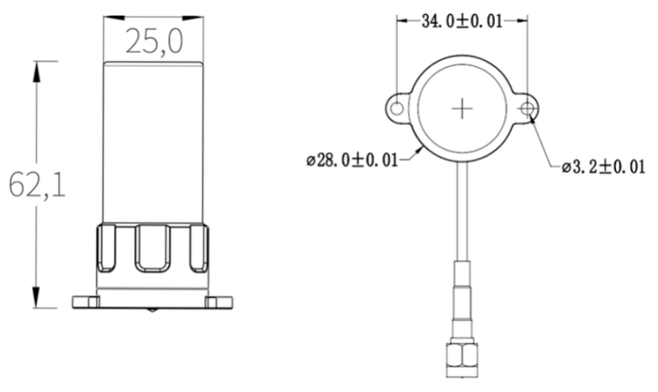
Antenna size
|
Φ120*14mm
|
Φ120*17.78mm
|
φ81*19mm
|
Φ41*31mm
|
Φ62.1*25mm
|
|
Product weight
|
174.6g
|
103.6g
|
94g
|
15.4g
|
25.4g
|
|
joint
|
MMCX (Customizable)
|
MMCX (Customizable)
|
MMCX (customizable)
|
MMCX(Customizable)
|
SMA-J (Inner screw inner pin)
|
|
Line type
|
RG178 (Customizable)
|
RG178 (Customizable)
|
RG178 (customizable)
|
RG178(Customizable)
|
RG316(Customizable)
|
|
Line length
|
150mm (Customizable)
|
150mm (Customizable)
|
150mm (customizable)
|
150mm(Customizable)
|
150mm(Customizable)
|
|
Environmental
Characteristics
|
Operating Temperature
|
-40℃~+85℃, 10%~95% RH
|
-40℃~+85℃, 10%~95% RH
|
-40℃~+85℃,10%~95% RH
|
-40℃~+85℃, 10%~95% RH
|
-40℃~+85℃, 10%~95% RH
|
|
Storage Temperature
|
-55℃~+100℃, 10%~95% RH
|
-55℃~+100℃, 10%~95% RH
|
-55℃~+100℃,10%~95% RH
|
-55℃~+100℃, 10%~95% RH
|
-55℃~+100℃, 10%~95% RH
|
|
Vibration
|
Sine sweep @1.5mmAM
10~55Hz each Axis
|
Sine sweep @1.5mmAM
10~55Hz each Axis
|
Sine sweep frequency @ 1.5mmAM, 10~55Hz per axis
|
Sine sweep @1.5mmAM 10~55Hz each Axis
|
Sine sweep @1.5mmAM
10~55Hz each Axis
|
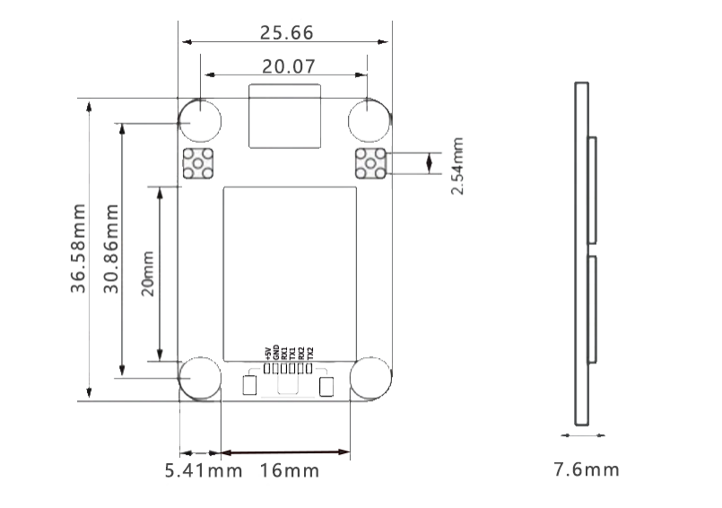
Table 1 PIN Functionality
|
NO.
|
Signal name
|
Signal Description
|
|
1
|
VCC
|
Power input, DC+5V
|
|
2
|
GND
|
grounding
|
|
3
|
RX1
|
Main serial port (COM1) data transmission, output NMEA0183 format positioning results when configured as "mobile
station", and output RTCM2. x/3. x format differential data stream when configured as "reference station".
|
|
4
|
TX1
|
Main serial port (COM1) data reception, configure command input port.
|
|
5
|
RX2
|
COM2 output interface
|
|
6
|
TX2
|
COM2 differential serial port (COM2) data input, only valid when configured as "mobile station", accepts RTCM2. x/3. x format differential data input.
|
|
7
|
TYPE-C
|
COM3 output interface
|
 AK613:

AK810:

AK711:

AK161:
Packaging and Delivery:

High-Precision GNSS Engine for Drones and Precision Agriculture
The DALANG AK315 is a centimeter-level high-precision RTK positioning module based on the UM980 chip, supporting full-constellation, all-frequency signals including GPS, BDS, GLONASS, Galileo, and QZSS. Utilizing 22nm advanced process technology, it integrates 1408 super channels and a dual-core processor, delivering 20 Hz high-frequency positioning output—providing a reliable centimeter-level solution for UAV navigation, smart agriculture, and surveying applications.
Real-Time High-Frequency RTK Technology
Equipped with the "UGypsophila" RTK engine and instant initialization technology, the module achieves a fixed solution within 5 seconds, with horizontal accuracy of 0.8 cm + 1 ppm. Whether installed on autonomous drones or agricultural machinery, it ensures stable and reliable real-time position tracking.
Excellent Anti-Interference Performance
Incorporating 60 dB narrowband anti-jamming and JamShield™ technology, it maintains stable signal reception in challenging environments such as urban canyons, mountainous areas, and forests, meeting positioning demands under harsh operating conditions.
Optimized for Open-Source Systems
Fully compatible with open-source flight control systems like ArduPilot and PX4, the module supports multiple communication protocols including NMEA0183 and RTCM 3.3, and provides various interfaces such as TYPE‑C and TTL for rapid deployment by integrators.
Product Advantages
-
Full-constellation, all-frequency support for seamless global positioning
-
20 Hz high-frequency output for dynamic applications
-
Ultra-fast initialization: centimeter-level accuracy within 5 seconds
-
Strong anti-interference capability for complex environments
-
Low-power design: only 800 mW power consumption
-
Compact size (36.58 × 25.66 × 7.6 mm) for easy integration
Need centimeter-level accuracy for your drone or agricultural system? Choose the DALANG AK315 GNSS module today and elevate your project with reliable, multi-constellation RTK performance.
About Us
DALANG is a dedicated manufacturer of high-performance GNSS modules and RTK positioning solutions, serving industries such as UAV navigation, precision agriculture, and geospatial mapping. With a clear focus on accuracy, reliability, and integration flexibility, we support both standard and custom applications across global markets. Our product lines are engineered to meet the evolving demands of real-time positioning with support for multiple GNSS constellations, including GPS, GLONASS, BDS, and Galileo.
Our production facility spans 2,500㎡ and includes advanced SMT lines, in-house R&D labs, and full functional testing for every unit shipped. With a team of 30+ GNSS engineers, we design and manufacture over 200,000 GNSS receivers and modules annually. Certified to ISO9001:2015, and compliant with CE and RoHS standards, we follow a strict quality assurance process from prototyping through mass production. We also provide firmware updates, system integration support, and full lifecycle product documentation.
Trusted by partners in over 30 countries, DALANG delivers fast, scalable manufacturing with personalized technical support. Our streamlined collaboration model—covering inquiry, consultation, prototyping, and delivery—ensures efficiency from first contact to deployment. Whether you're sourcing off-the-shelf GNSS hardware or launching a customized solution, DALANG is your dependable partner for accurate, cost-effective positioning systems.
FAQ
1. Who are we?
We are DALANG, a specialized manufacturer of GNSS modules and RTK positioning systems based in China, with a focus on high-precision solutions for UAVs, surveying, and smart agriculture.
2. How can we guarantee quality?
All products undergo strict multi-stage quality control, including SMT production, functional testing, and 100% final inspection. We are ISO9001:2015 certified and follow international compliance standards such as CE and RoHS.
3. What can you buy from us?
You can purchase GNSS receivers, RTK modules, base stations, antennas, flight control positioning systems, and other GNSS-related components and accessories.
4. Why should you buy from us not from other suppliers?
We combine strong in-house R&D, flexible OEM/ODM support, industrial-grade quality assurance, and fast global delivery. Our expertise in GNSS RTK ensures stable, accurate, and scalable solutions tailored to your specific use case.
5. What services can we provide?
We offer OEM/ODM customization, technical consulting, firmware support, prototyping, and global after-sales service. Our team works closely with international clients to ensure efficient communication and long-term support.


